Aoös
| Αώος (Aoös) Vjosa | |
|---|---|
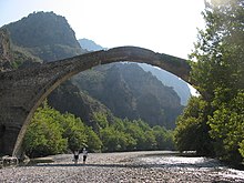
 Aoös/Vjosa near Tepelenë | |
 | |
| Location | |
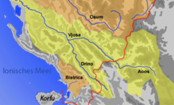
| Countries | Albania and Greece |
| Physical characteristics | |
| Source | |
| • location | Pindus, Greece |
| Mouth | |
• location | Adriatic Sea, Albania |
• coordinates | 40°38′34″N 19°19′2″E / 40.64278°N 19.31722°ECoordinates: 40°38′34″N 19°19′2″E / 40.64278°N 19.31722°E |
• elevation | 0 m (0 ft) |
| Length | 272 kilometres (169 mi) |
| Basin size | 6,706 km2 (2,589 sq mi) |
| Discharge | |
| • average | 195 m3/s (6,900 cu ft/s) |

The Aoös (Greek: Αώος) or Vjosa (Albanian: [ˈvjɔsə]) is a river in northwestern Greece and southwestern Albania. Its total length is about 272 kilometres (169 mi),[1] of which the first 80 kilometres (50 mi) are in Greece, and the remaining 192 kilometres (119 mi) are in Albania.[2] Its drainage basin is 6,706 km2 (2,589 sq mi) and its average discharge is 195 m3/s (6,900 cu ft/s).[1] It is fed by several tributaries, such as the Voidomatis, Sarantaporos, Drino and Shushicë.
The Aoös arises in the Pindus mountains of Epirus, Greece, near the village of Vovousa.[3][4] An artificial lake has been constructed at an elevation of 1,350 metres (4,430 ft),[5] where a hydroelectric dam has been in place since 1987. The river flows through the canyons of Vikos–Aoös National Park, and then through the town of Konitsa, where it is joined by the Voidomatis. It enters Albania near Çarshovë as the Vjosa River Managed Nature Reserve[6] where it is joined by the Sarantaporos, and then continues northwest through Përmet, Këlcyrë, and Tepelenë (where it is joined by the Drino), Memaliaj, Selenicë and Novoselë. It then flows into the Adriatic Sea, northwest of Vlorë. The river's mouth is within the boundaries of the Vjosa-Narta Protected Landscape. In December 2020, the Albanian portion of the river was designated a "Managed Nature Reserve" by the Albanian government.[6]
Name[]
The river is known by a number of different names. In antiquity it was called Aoös (Ἄωος, Ἀῶος, Ἀῷος) in Greek, and Aous in Latin. In Albanian it is called Vjosë or Vjosa, while in Greece it is known by its ancient name (Αώος in modern orthography), in medieval Latin maps was called Viossa as well as Vovousa (Βοβούσα) or Aias (Αίας, Αἴας).[7] In Aromanian it is Băiasa.
Vjosa is a common female Albanian given name.[8][9][10]
Human history[]
In Greek mythology,[11] Aous is an epithet or name of Adonis.[12] was also the name of the first king of Cyprus. A river and a mountain[13] in Cyprus were also named .[11]
Hecataeus (550–476 BC) refers to the river as Aias (Greek: Αἴας), the name Anios (Greek: Ἄνιος) is used by Plutarch in Caesar,[14] while Polybius, Livy and Strabo use the term Aoös. The Thesprotian tribe of Parauaioi received their name from the river, as those living beside it. Pausanias writes of "sharks"[15] (Greek: θηρία) in the river, as it flows through Thesprotia. It is mentioned as Avos (Greek: Αύος) by Stephanus of Byzantium[16] in the 6th century AD.
In 274 BC Pyrrhus of Epirus defeated Antigonus II Gonatas near the river's banks. In 198 BC, Philip V of Macedon and the Roman Titus Quinctius Flamininus, clashed in the Battle of the Aous. In 170 BC[17] a plot to kidnap Aulus Hostilius Mancinus was foiled by Molossians by mistake. In antiquity the river passed more to the north[citation needed], towards where Fier lies today. Owing to an earthquake[citation needed] in the 4th century, it changed to its present course. The earthquake and changed river course led to the decline of the ancient Greek city of Apollonia.[citation needed]
Greece[]
The Vikos–Aoös National Park (Greek: Εθνικός Δρυμός Βίκου–Αώου Ethnikós Drymós Víkou–Aóou), created in 1973, is a national park in Epirus in northwestern Greece. The national park encompasses 126 square kilometres (31,135 acres) of mountainous terrain, with numerous rivers, lakes, caves, canyons, and coniferous and deciduous forest. The core of the 3,400 hectare park[18] is the Vikos Gorge, carved by the Voidomatis River, while the Aoos Gorge, Mount Tymfi, with its highest peak, Gamila, at 2,497 metres (8,192 ft), and a number of settlements forming the park's peripheral zone.
Albania[]


In February 2005, the Albanian government made the Vjose-Narte wetlands a protected area. This legislation followed Albania's ratification of the Kyoto Protocol in December 2004. The river contributes water to the Vjosë-Levan-Fier irrigation canal, a canal that was built in the 1950s to irrigate the Myzeqe. In December 2020, the Albanian portion of the river was designated a "Managed Nature Reserve" by the Albanian government.[6]
Conservation[]
The Vjosa's potential for hydropower has attracted developers to submit proposal to planning authorites for dam projects along the river and its tributeries. By 2017, over 2000 dam projects had gained governmental approval on stretches of river throughout the Balkans, including the Vjosa's channel.[19] Developers have met with opposition from European nature organisations including RiverWatch, ,[20] and .[21]
A 2012 study assessed the hydromorphology of the Balkan's rivers, taking into account the structural status of 35,000 river kilometres. The study showed that the region's rivers are largely intact, with 30% deemed pristine and 50% slightly modified.[22]
In February 2020, a campaign to elevate the status of the Vjosa watershed to Vjosa National Park gained approval from 20 environmental groups under the leadership of EcoAlbania. The effort to create Europe's first wild river park and save 300 km of rivers and streams targeted several projects identified in a February 2021 proposal.[23]
In September 2020, Albanian Prime Minister Edi Rama announced that a protected area will be created around the Vjosa. In December 2020, the Albanian government designated the Vjosa River as a "Managed Nature Reserve" or nature park.[6] Environmental groups are skeptical of the level of protection afforded by "protected" status. A national park designation would prohibit hydroelectric projects, airports, and other development; a protected area designation would not.[2]
In April 2021 a petition signed by Vjosa River scientists was delivered to Albanian President Ilir Meta.[24] The scientists immediate concern is a plan by a Turkish-Albanian venture, , to build a 50-metre high hydroelectric dam. It would be the first development to change the course of Albania's 200 kilometre portion of the river. The dam would flood areas populated with the 1,175 animal and plant species—some endangered. It would inundate farmland, destroy the river's fishery, and force thousands from their homes. Activists maintain that the government should focus on other less damaging renewable energy sources.[2]
Lists[]
- Tributaries: Drino, Shushicë, Sarantaporos, Voidomatis
- Cities and towns (in upstream order) along the river:
- River crossings: Konitsa Bridge, Bridge, Bridge
Map[]
See also[]
- List of rivers of Albania
- List of rivers of Europe
- List of rivers of Greece
References[]
- ^ Jump up to: a b Cullaj, A., Hasko, A., Miho, A., Schanz, F., Brandl, H. & Bachofen, R. (2005). "The quality of Albanian natural waters and the human impact". Environment International. 31 (1): 138. doi:10.1016/j.envint.2004.06.008. PMID 15607787.CS1 maint: uses authors parameter (link)
- ^ Jump up to: a b c Mema, Bresiloa; Boyle, Joseph (14 May 2021). "Undammed, undimmed: The battle over a unique European river". Bangkok Post. Agence France-Presse. Retrieved 14 May 2021.
- ^ Acta Hydrochimica Et Hydrobiologica. VCH Verlagsgesellschaft. 2001.
- ^ William Bowden (2003). Epirus Vetus: the archaeology of a late antique province. Duckworth. ISBN 978-0-7156-3116-4.
- ^ Egnatia Municipality Archived August 2, 2009, at the Wayback Machine
- ^ Jump up to: a b c d http://planifikimi.gov.al/index.php?eID=dumpFile&t=f&f=6099&token=cc165dfe23b6652028a4de33944dee2fca23bd8f
- ^ Λαμπρίδης Ιωάννης "Ζαγοριακά", Τυπογραφείον Αυγής, Αθήνα, 1870
- ^ From 20000 names babynames website
- ^ From Aboutnames babynames website
- ^ Albanian names website
- ^ Jump up to: a b Parthenius (of Nicaea) (1999). Parthenius of Nicaea: The Poetical Fragments and the Erōtika Pathēmata. Clarendon Press. p. 182. ISBN 978-0-19-815253-8.
- ^ Yves Bonnefoy (1992). Greek and Egyptian Mythologies. University of Chicago Press. p. 135. ISBN 978-0-226-06454-3.
- ^ Joseph Eddy Fontenrose (1981). Orion: The Myth of the Hunter and the Huntress. University of California Press. p. 103. ISBN 978-0-520-09632-5.
- ^ Dictionary of Greek and Roman Geography (1854)
- ^ Paus. 4.34,"But the rivers of Greece contain no terrors from wild beasts, for the sharks of the Aous, which flows through Thesprotia, are not river beasts but migrants from the sea."
- ^ Ethnica Epitome,"Παρά τον Αύον ποταμόν"
- ^ A History of Macedonia: 336-167 B.C, Nicholas Geoffrey Lemprière Hammond, Frank William Walbank, 1988, ISBN 0198148151, p. 520
- ^ Trakolis: p. 3
- ^ Ross, Will (22 March 2017). "Rising On Edges: Anti-Damming on the Wild Rivers of the Balkans". Zafiri. Retrieved 14 May 2021.
- ^ "Vjosa National Park NOW". EuroNatur. Retrieved 14 May 2021.
- ^ "Profile". EcoAlbania. Retrieved 14 May 2021.
- ^ Schwarz, Ulrich (March 2012). "Balkan Rivers - The Blue Heart of Europe; Hydromorphological Status and Dam Projects Report" (PDF). Balkan Rivers. FLUVIUS. Retrieved 14 May 2021.
- ^ "Proposal for establishing the Vjosa Wild River National Park" (PDF). EcoAlbania. February 2021. Retrieved 14 May 2021.
- ^ "Petition of Scientists of the Vojsa River handed to Albanian President". Tour du Valat. 2020-04-01. Retrieved 2021-04-18.
External links[]
| Wikimedia Commons has media related to River_Aoos-Vjosa. |

| Authority control: National libraries |
|---|
- Rivers of Albania
- Rivers of Greece
- International rivers of Europe
- Aoös basin
- Landforms of Ioannina (regional unit)
- Rivers of Epirus (region)
- Pindus
- Braided rivers in Albania