Sharoe Green
| Sharoe Green | |
|---|---|
 Ward location in the City of Preston district | |
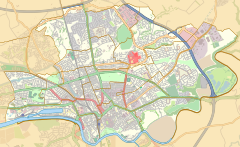 Sharoe Green Location in Preston | |
| Population | 6,279 (2011) |
| District | |
| Ceremonial county | |
| Region | |
| Country | England |
| Sovereign state | United Kingdom |
| UK Parliament | |
| Councillors |
|


Sharoe Green (/ˈʃɛrə/) is a largely residential suburban area of Preston, Lancashire, England, and an electoral ward. It is nowadays usually considered to be a district of the larger suburb of Fulwood (and formed part of the pre-1974 Fulwood Urban District). Preston golf course is within the ward boundaries, and the Royal Preston Hospital, now the sole main provider of NHS hospital treatment in the city.
Sharoe Green is a district of Preston with its near neighbour Sherwood, positioned to the far northeast of the city centre adjoining Deepdale. Its major transport links are served by the local and national bus routes criss-crossing its boundaries. The ward of Sharoe Green is a three-member electoral division, returning three councillors to Town Hall. With its neighbour Garrison, the ward forms part of the one-member Preston North East division of Lancashire County Council.
Current councillors[]
| Election | Member | Party | |
|---|---|---|---|
| 2019 Preston City Council election | Daniel Duckworth | Conservative Party | |
| 2019 Preston City Council election | Maxwell Green | Conservative Party | |
| 2021 Preston City Council election | David Walker | Conservative Party | |
Demographics[]
At the 2001 census, the population of Sharoe Green was 6,819, with over 80% regarding themselves as Christian.[1] At the 2008 local elections in Preston, Sharoe Green had a valid electorate of 5,103,[2] increasing again to 6,279 at the 2011 Census.[3]
References[]
- ^ Neighbourhood Statistics: Sharoe Green (Ward)
- ^ Electoral Ward Results[permanent dead link]
- ^ UK Census (2011). "Local Area Report – Sharoe Green 2011 Census Ward (1237324290)". Nomis. Office for National Statistics. Retrieved 11 March 2018.
Geography of the City of Preston district | |||||||
|---|---|---|---|---|---|---|---|
| Cities |  | ||||||
| Suburbs | |||||||
| Villages |
| ||||||
| Parishes | |||||||
| Topography |
| ||||||
| |||||||
This Lancashire location article is a stub. You can help Wikipedia by . |
- Geography of Preston
- Wards of Preston
- Lancashire geography stubs