Shawano, Wisconsin
Shawano, Wisconsin | |
|---|---|
 Shawano Main Street Historic District | |
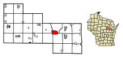 Location of Shawano in Shawano County, Wisconsin. | |
| Coordinates: 44°46′36″N 88°36′7″W / 44.77667°N 88.60194°WCoordinates: 44°46′36″N 88°36′7″W / 44.77667°N 88.60194°W | |
| Country | |
| State | |
| County | Shawano |
| Area | |
| • Total | 6.94 sq mi (17.96 km2) |
| • Land | 6.70 sq mi (17.35 km2) |
| • Water | 0.24 sq mi (0.62 km2) |
| Elevation | 817 ft (249 m) |
| Population | |
| • Total | 9,305 |
| • Estimate (2019)[5] | 8,935 |
| • Density | 1,334.18/sq mi (515.09/km2) |
| Time zone | UTC-6 (Central (CST)) |
| • Summer (DST) | UTC-5 (CDT) |
| Zip Code | 54166 |
| Area code(s) | 715 & 534 |
| FIPS code | 55-72925[4] |
| GNIS feature ID | 1573978[3] |
| Website | City of Shawano |


Shawano (pronounced SHAW-no) is a city in Shawano County, Wisconsin, United States. The population was 9,305 at the 2010 census. It is the county seat of Shawano County.[6]
History[]
The name is from the Chippewa language, meaning "southern".[7] (Cf. Ojibwe zhaawanong "in, to, from the south".) In the related Menominee language, it is known as Sāwanoh; this translates into English as "south".[8]
Geography[]
Shawano is located at 44°46′36″N 88°36′7″W / 44.77667°N 88.60194°W (44.776612, -88.602054).[9] According to the United States Census Bureau, the city has a total area of 6.67 square miles (17.28 km2), of which, 6.57 square miles (17.02 km2) is land and 0.10 square miles (0.26 km2) is water.[10]
Transportation[]
Major highways[]
| WIS 22 travels north to Gillett and south to Clintonville. | |
| WIS 29 Eastbound WIS 29 routes to Green Bay. Westbound, WIS 29 routes to Wausau. | |
| WIS 47 travels north concurrent with WIS 55 to Keshena and south 8 miles (13 km) east on WIS 29 at Bonduel to Appleton. | |
| WIS 55 travels south concurrent with WIS 29 before it splits off towards Seymour 16 miles (26 km) to the east. |
Airport[]
The city and county jointly operate the Shawano Municipal Airport (KEZS) which is located on Shawano Lake.
Demographics[]
| Historical population | |||
|---|---|---|---|
| Census | Pop. | %± | |
| 1880 | 890 | — | |
| 1890 | 1,505 | 69.1% | |
| 1900 | 1,863 | 23.8% | |
| 1910 | 2,923 | 56.9% | |
| 1920 | 3,544 | 21.2% | |
| 1930 | 4,188 | 18.2% | |
| 1940 | 5,565 | 32.9% | |
| 1950 | 5,894 | 5.9% | |
| 1960 | 6,013 | 2.0% | |
| 1970 | 6,488 | 7.9% | |
| 1980 | 7,013 | 8.1% | |
| 1990 | 7,598 | 8.3% | |
| 2000 | 8,298 | 9.2% | |
| 2010 | 9,305 | 12.1% | |
| 2019 (est.) | 8,935 | [5] | −4.0% |
| U.S. Decennial Census[11] | |||
2010 census[]
As of the census[2] of 2010, there were 9,305 people, 3,960 households, and 2,299 families residing in the city. The population density was 1,416.3 inhabitants per square mile (546.8/km2). There were 4,309 housing units at an average density of 655.9 per square mile (253.2/km2). The racial makeup of the city was 82.4% White, 0.7% African American, 12.3% Native American, 0.4% Asian, 0.1% Pacific Islander, 1.2% from other races, and 2.8% from two or more races. Hispanic or Latino of any race were 3.1% of the population.
There were 3,960 households, of which 28.9% had children under the age of 18 living with them, 40.7% were married couples living together, 12.6% had a female householder with no husband present, 4.8% had a male householder with no wife present, and 41.9% were non-families. 35.6% of all households were made up of individuals, and 17% had someone living alone who was 65 years of age or older. The average household size was 2.24 and the average family size was 2.89.
The median age in the city was 39.8 years. 23% of residents were under the age of 18; 8.1% were between the ages of 18 and 24; 25.3% were from 25 to 44; 23.8% were from 45 to 64; and 19.8% were 65 years of age or older. The gender makeup of the city was 47.2% male and 52.8% female.
2000 census[]
As of the census[4] of 2000, there were 8,298 people, 3,432 households, and 2,076 families residing in the city. The population density was 1,389.9 per square mile (536.6/km2). There were 3,587 housing units at an average density of 600.8 per square mile (232.0/km2). The racial makeup of the city was 89.03% White, 0.33% African American, 7.88% Native American, 0.54% Asian, 0.12% Pacific Islander, 0.55% from other races, and 1.54% from two or more races. Hispanic or Latino of any race were 1.61% of the population.
There were 3,432 households, out of which 29.0% had children under the age of 18 living with them, 45.8% were married couples living together, 11.2% had a female householder with no husband present, and 39.5% were non-families. 34.7% of all households were made up of individuals, and 18.2% had someone living alone who was 65 years of age or older. The average household size was 2.27 and the average family size was 2.91.
24.0% of the population was under the age of 18, 7.9% from 18 to 24, 27.7% from 25 to 44, 19.8% from 45 to 64, and 20.5% who were 65 years of age or older. The median age was 38 years. For every 100 females, there were 91.0 males. For every 100 females age 18 and over, there were 86.9 males.
The median income for a household in the city was $31,546, and the median income for a family was $41,241. Males had a median income of $30,709 versus $19,905 for females. The per capita income for the city was $17,380. About 8.9% of families and 9.9% of the population were below the poverty line, including 11.4% of those under age 18 and 12.1% of those age 65 or over.
Economy[]
The Wisconsin Towns Association has its headquarters in Shawano.
Shawano is a member of Shawano County Economic Progress, Inc. (SCEPI), a countywide economic development organization.[12]
Shawano was ranked by NerdWallet as the 10th best place to start a business in Wisconsin.[13]
Notable people[]
- George E. Beedle — Wisconsin State Representative, was born in Shawano.[14]
- Henry Albert Brauer — Wisconsin State Representative, lived in Shawano.[15]
- Robert W. Cone — United States Army General, lived in Shawano.[16]
- Walter J. Dolan — Wisconsin State Representative, lived in Shawano.[17]
- Evelyn Frechette — love and accomplice of John Dillinger, lived in Shawano.[18]
- George Grimmer — Wisconsin State Senator, lived in Shawano.[19]
- William Horvath — Wisconsin State Representative and conservationist, born in Shawano.[20]
- Frank W. Humphrey — Wisconsin State Representative, lived in Shawano.[21]
- John David Kast — Wisconsin State Representative, lived in Shawano.[22]
- Antone Kuckuk — Wisconsin State Senator, was a member of the Shawano School Board.[23]
- George W. Latta — Wisconsin State Representative and lawyer, lived in Shawano.[24]
- Daniel P. Leaf — U.S. Air Force Lieutenant General, former Commander of United States Pacific Command.[25]
- Louis Leroy — MLB player, lived in Shawano.[26]
- Joseph McCarthy once worked here as a lawyer in the 1930s. He was also a circuit court judge.[27]
- Myron Hawley McCord — U.S. Representative, lived in Shawano.[28]
- Herman Naber — Wisconsin State Representative, lived in and was mayor of Shawano[29]
- Dan Neumeier — MLB player, was born in Shawano.[30]
- Daniel H. Pulcifer — Wisconsin State Representative, lived in and was mayor of Shawano[31]
- Billy Reed — MLB player, was born in Shawano.[32]
- Lee Remmel — NFL historian, was born and raised in Shawano.[33]
- Michael J. Wallrich — Wisconsin State Representative, lived in and was Mayor of Shawano.[34]
- King Weeman — Wisconsin State Representative, lived in and was Mayor of Shawano.[35]
- Otto Oscar Wiegand — Wisconsin State Representative, lived in Shawano.[36]
- — Shawano Alderman, lives in Wescott. <ref> http://www.newmedia-wi.com/content/shawano-county-contested-election-race-results <ref>
Images[]

City hall

Shawano Post Office, listed on the National Register of Historic Places

Shawano Business District (taken on Business 29)

Shawano City County Library


References[]
- ^ "2019 U.S. Gazetteer Files". United States Census Bureau. Retrieved August 7, 2020.
- ^ Jump up to: a b "U.S. Census website". United States Census Bureau. Retrieved 2012-11-18.
- ^ Jump up to: a b "US Board on Geographic Names". United States Geological Survey. 2007-10-25. Retrieved 2008-01-31.
- ^ Jump up to: a b "U.S. Census website". United States Census Bureau. Retrieved 2008-01-31.
- ^ Jump up to: a b "Population and Housing Unit Estimates". United States Census Bureau. May 24, 2020. Retrieved May 27, 2020.
- ^ "Find a County". National Association of Counties. Retrieved 2011-06-07.
- ^ "Term: Shawano County (origin of place name)", Dictionary of Wisconsin History.
- ^ Hoffman, Mike. "Menominee Place Names in Wisconsin". The Menominee Clans Story. Retrieved 2018-10-06.
- ^ "US Gazetteer files: 2010, 2000, and 1990". United States Census Bureau. 2011-02-12. Retrieved 2011-04-23.
- ^ "US Gazetteer files 2010". United States Census Bureau. Archived from the original on 2012-01-25. Retrieved 2012-11-18.
- ^ "Census of Population and Housing". Census.gov. Retrieved June 4, 2015.
- ^ "Shawano County Economic Progress".
- ^ Jonathan Todd. Best Places to Start a Business in Wisconsin. NerdWallet, July 13, 2015.
- ^ http://files.usgwarchives.net/wi/history/bluebook/1909/bios/beedle876gbs.txt
- ^ The Blue Book of the State of Wisconsin. 1893. p. 652.
- ^ 'Local retired general passes away,' The Shawano Leader, September 21, 2016
- ^ 'Wisconsin Blue Book 1933,' Biographical Sketch of Walter J. Dolan, pg. 255
- ^ flasputnik. "WISCONSINOLOGY: Dillinger's Girl....Billie Frechette".
- ^ "The Legislative Manual of the State of Wisconsin". 1877.
- ^ 'Wisconsin Blue Book 1987-1988,' Addenda: Biographical Sketch of William Horvath, pg. 956
- ^ The Law Makers of Wisconsin. Milwaukee: The Evening Wisconsin Company. 1899. p. 72.
- ^ THE LEGISLATIVE MANUAL OF THE STATE OF WISCONSIN (16th ed.). Madison, Wis. 1877. pp. 469–470.
- ^ "Wisconsin Blue Book, 1923". 1923.
- ^ 'Wisconsin blue Book 1897,' Biographical Sketch of George W. Latta, pg. 684
- ^ "Biographies : LIEUTENANT GENERAL DANIEL P. LEAF". archive.is. Archived from the original on 22 July 2012.
- ^ "Louis LeRoy Statistics and History - Baseball-Reference.com". Baseball-Reference.com.
- ^ "Joseph McCarthy: Biography". Appleton Public Library. Retrieved May 14, 2018.
- ^ "McCORD, Myron Hawley - Biographical Information".
- ^ 'Wisconsin Blue Book 1909,' Biographical Sketch of Herman Naber, pg. 504
- ^ "Dan Neumeier Statistics and History - Baseball-Reference.com". Baseball-Reference.com.
- ^ 'Wisconsin Blue Book 1879,' Biographical Sketch of Daniel H. Pulcifer, pg. 500-501
- ^ "Billy Reed Statistics and History - Baseball-Reference.com". Baseball-Reference.com.
- ^ "Lee Remmel, Green Bay Packers Team Historian, To Retire After 62-Year Association With Franchise". Green Bay Packers. Archived from the original on 2018-05-14. Retrieved May 14, 2018.
- ^ http://files.usgwarchives.net/wi/history/bluebook/1903/bios/wallrich162[permanent dead link] gbs.txt
- ^ 'Wisconsin Blue Book 1919,' Biographical Sketch of King Weeman, pg. 503
- ^ The Blue Book of the State of Wisconsin. 1891. p. 602.
External links[]
| Wikimedia Commons has media related to Shawano, Wisconsin. |
- City of Shawano
- Sanborn fire insurance maps: 1894 1901 1907 1913
| show Municipalities and communities of Shawano County, Wisconsin, United States |
|---|

| show Authority control |
|---|
- Cities in Wisconsin
- Cities in Shawano County, Wisconsin
- County seats in Wisconsin