Shepherd, Michigan
Shepherd, Michigan | |
|---|---|
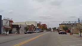 Looking west along W. Wright Avenue | |
 Location within Isabella County | |
 Shepherd Location within the state of Michigan | |
| Coordinates: 43°31′28″N 84°41′41″W / 43.52444°N 84.69472°WCoordinates: 43°31′28″N 84°41′41″W / 43.52444°N 84.69472°W | |
| Country | United States |
| State | Michigan |
| County | Isabella |
| Township | Coe |
| Area | |
| • Total | 0.96 sq mi (2.48 km2) |
| • Land | 0.96 sq mi (2.48 km2) |
| • Water | 0.00 sq mi (0.00 km2) |
| Elevation | 774 ft (236 m) |
| Population | |
| • Total | 1,515 |
| • Estimate (2019)[5] | 1,486 |
| • Density | 1,552.77/sq mi (599.42/km2) |
| Time zone | UTC-5 (Eastern (EST)) |
| • Summer (DST) | UTC-4 (EDT) |
| ZIP code(s) | 48883 |
| Area code(s) | 989 |
| FIPS code | 26-72960[3] |
| GNIS feature ID | 0637740[4] |
| Website | Official website |

Shepherd is a village in Isabella County in the U.S. state of Michigan. The population was 1,515 at the 2010 census. The village is within Coe Township.
Geography[]
According to the United States Census Bureau, the village has a total area of 0.97 square miles (2.51 km2), all of it land.[6]
Demographics[]
| Historical population | |||
|---|---|---|---|
| Census | Pop. | %± | |
| 1890 | 469 | — | |
| 1900 | 635 | 35.4% | |
| 1910 | 835 | 31.5% | |
| 1920 | 823 | −1.4% | |
| 1930 | 839 | 1.9% | |
| 1940 | 852 | 1.5% | |
| 1950 | 899 | 5.5% | |
| 1960 | 1,293 | 43.8% | |
| 1970 | 1,416 | 9.5% | |
| 1980 | 1,534 | 8.3% | |
| 1990 | 1,413 | −7.9% | |
| 2000 | 1,536 | 8.7% | |
| 2010 | 1,515 | −1.4% | |
| 2019 (est.) | 1,486 | [5] | −1.9% |
| U.S. Decennial Census[7] | |||
2010 census[]
As of the census[2] of 2010, there were 1,515 people, 640 households, and 412 families living in the village. The population density was 1,561.9 inhabitants per square mile (603.1/km2). There were 699 housing units at an average density of 720.6 per square mile (278.2/km2). The racial makeup of the village was 94.2% White, 0.5% African American, 1.3% Native American, 0.3% Asian, 0.9% from other races, and 2.8% from two or more races. Hispanic or Latino of any race were 3.2% of the population.
There were 640 households, of which 31.7% had children under the age of 18 living with them, 43.3% were married couples living together, 14.7% had a female householder with no husband present, 6.4% had a male householder with no wife present, and 35.6% were non-families. 30.8% of all households were made up of individuals, and 11.4% had someone living alone who was 65 years of age or older. The average household size was 2.36 and the average family size was 2.92.
The median age in the village was 37.5 years. 24.5% of residents were under the age of 18; 9% were between the ages of 18 and 24; 25.7% were from 25 to 44; 27.8% were from 45 to 64; and 13% were 65 years of age or older. The gender makeup of the village was 46.7% male and 53.3% female.
2000 census[]
As of the census[3] of 2000, there were 1,536 people, 619 households, and 417 families living in the village. The population density was 1,586.7 per square mile (611.4/km2). There were 641 housing units at an average density of 662.2 per square mile (255.1/km2). The racial makeup of the village was 96.35% White, 0.46% African American, 0.52% Native American, 0.33% Asian, 0.65% from other races, and 1.69% from two or more races. Hispanic or Latino of any race were 2.34% of the population.
There were 619 households, out of which 36.0% had children under the age of 18 living with them, 49.9% were married couples living together, 13.1% had a female householder with no husband present, and 32.5% were non-families. 29.6% of all households were made up of individuals, and 9.7% had someone living alone who was 65 years of age or older. The average household size was 2.47 and the average family size was 3.07.
In the village, the population was spread out, with 27.5% under the age of 18, 10.9% from 18 to 24, 30.3% from 25 to 44, 19.5% from 45 to 64, and 11.7% who were 65 years of age or older. The median age was 34 years. For every 100 females, there were 89.6 males. For every 100 females age 18 and over, there were 82.5 males.
The median income for a household in the village was $40,804, and the median income for a family was $49,135. Males had a median income of $33,011 versus $21,950 for females. The per capita income for the village was $17,689. About 9.2% of families and 10.5% of the population were below the poverty line, including 14.7% of those under age 18 and 4.7% of those age 65 or over.
Shepherd Maple Syrup Festival[]
The village has a well-attended Maple Syrup Festival the last full weekend of April. The annual tradition began in 1959 and includes arts, crafts, music, food and a parade featuring the Shepherd Maple Syrup Festival Queen. 2,375.1 gallons of syrup were produced in 2013, a new record for the town. http://www.shepherdmaplesyrupfest.org/
Notable people[]
- Len Kasper, radio announcer for the Chicago White Sox
Climate[]
This climatic region is typified by large seasonal temperature differences, with warm to hot (and often humid) summers and cold (sometimes severely cold) winters. According to the Köppen Climate Classification system, Shepherd has a humid continental climate, abbreviated "Dfb" on climate maps.[8]
References[]
- ^ "2019 U.S. Gazetteer Files". United States Census Bureau. Retrieved July 25, 2020.
- ^ Jump up to: a b "U.S. Census website". United States Census Bureau. Retrieved 2012-11-25.
- ^ Jump up to: a b "U.S. Census website". United States Census Bureau. Retrieved 2008-01-31.
- ^ U.S. Geological Survey Geographic Names Information System: Shepherd, Michigan
- ^ Jump up to: a b "Population and Housing Unit Estimates". United States Census Bureau. May 24, 2020. Retrieved May 27, 2020.
- ^ "US Gazetteer files 2010". United States Census Bureau. Archived from the original on 2012-01-25. Retrieved 2012-11-25.
- ^ "Census of Population and Housing". Census.gov. Retrieved June 4, 2015.
- ^ Climate Summary for Shepherd, Michigan
External links[]
| show Municipalities and communities of Isabella County, Michigan, United States |
|---|

| show Authority control |
|---|
- Villages in Isabella County, Michigan
- Villages in Michigan