Shingō, Aomori
Shingō
新郷村 | |
|---|---|
Village | |
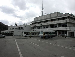 Shingō Village Office | |
 Flag  Seal | |
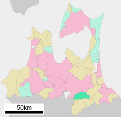 Location of Shingō in Aomori Prefecture | |
 Shingō | |
| Coordinates: 40°27′49.19″N 141°10′27.53″E / 40.4636639°N 141.1743139°ECoordinates: 40°27′49.19″N 141°10′27.53″E / 40.4636639°N 141.1743139°E | |
| Country | Japan |
| Region | Tōhoku |
| Prefecture | Aomori |
| District | Sannohe |
| Area | |
| • Total | 150.77 km2 (58.21 sq mi) |
| Population (March 2020) | |
| • Total | 2,408 |
| • Density | 16/km2 (41/sq mi) |
| Time zone | UTC+9 (Japan Standard Time) |
| - Tree | Aesculus |
| - Flower | Asian skunk cabbage |
| Phone number | 0178-78-2111 |
| Address | 039-0801 |
| Website | Official website |

Shingō (新郷村, Shingō-mura) is a village located in Aomori Prefecture, Japan. As of 31 March 2020, the village has an estimated population of 2,408 in 922 households[1] and a population density of 16 persons per km² (42 people per square mile). The total area of the village is 150.77 square kilometres (58.21 sq mi).[2]
Geography[]
Shingō is in south-central Aomori Prefecture, east of Lake Towada. The western edge of the village borders Akita Prefecture. Much of the village is mountainous with the outer ring mountains of Lake Towada, including Mt. Okomagatake (1,144 meters) and Mt. Toraidake (1,159 m). The village area extends along National Route 454, which connects Hachinohe City, Aomori Prefecture and Lake Towada.
Neighboring municipalities[]
Climate[]
The village has a cold Humid continental climate characterized by cool short summers and long cold winters with very heavy snowfall (Köppen climate classification Dfa). The average annual temperature in Shingō is 8.7 °C (47 °F). The average annual rainfall is 1342 mm (53 in.), with September as the wettest month. The temperatures are highest on average in August, at around 22.2 °C (72 °F), and lowest in January, at around -3.7 °C (25 °F).[3]
Demographics[]
Per Japanese census data,[4] the population of Shingō has declined steadily over the past 70 years.
| Year | Pop. | ±% |
|---|---|---|
| 1950 | 6,411 | — |
| 1960 | 6,409 | −0.0% |
| 1970 | 4,754 | −25.8% |
| 1980 | 4,332 | −8.9% |
| 1990 | 3,724 | −14.0% |
| 2000 | 3,343 | −10.2% |
| 2010 | 2,851 | −14.7% |
History[]
The area around Shingō was controlled by the Nambu clan of Morioka Domain during the Edo period. During the post-Meiji restoration establishment of the modern municipalities system on 1 April 1889, Herai Village and neighboring Nozawa Village were formed. On July 29, 1955 the western portion of Nozawa Village merged into Herai, which was then renamed Shingō.
Government[]
Shingō has a mayor-council form of government with a directly elected mayor and a unicameral village council of eight members. Shingō is part of Sannohe District which contributes three members to the Aomori Prefectural Assembly. In terms of national politics, the town is part of Aomori 2nd district of the lower house of the Diet of Japan.
Education[]
Shingō has two public elementary schools and two public middle schools operated by the village government. The village does not have a high school.
Economy[]
The economy of Shingō is heavily dependent on agriculture. Notable crops include edible chrysanthemum, Japanese yam and tobacco. Traditionally a horse breeding area, Shingō is also known for its cattle ranches.
Transportation[]
Railway[]
- The village has no passenger railway service.
Highway[]
Local attractions[]

Shingō village is the location of what is purported to be the resting place of Jesus, located in a what is attributed to be the "Tomb of Jesus" (Kirisuto no haka), and the residence of Jesus' last descendants, the family of Sajiro Sawaguchi.[5] According to these ahistorical claims, Jesus Christ did not die on the cross at Golgotha. Instead a man alleged to be his brother, Isukiri,[6] took his place on the cross, while Jesus travelled across Siberia to Mutsu Province, in northern Japan. Once in Japan, he is alleged to have changed his name to Torai Tora Daitenku, and to have become a rice farmer.
References[]
- ^ Shingō Village official statistics
- ^ 詳細データ 青森県青森県新郷村. 市町村の姿 グラフと統計でみる農林水産業 (in Japanese). Ministry of Agriculture, Forestry and Fisheries. 2016. Retrieved 13 July 2017.
- ^ Shingō climate data
- ^ Shingō population statistics
- ^ "From Japanese text of the sign included in this article". Archived from the original on December 11, 2019.
- ^ "Japan Travel: Jesus in Japan". Metropolis. Archived from the original on 2006-08-25. Retrieved 2006-12-13.
External links[]
![]() Media related to Shingō, Aomori at Wikimedia Commons
Media related to Shingō, Aomori at Wikimedia Commons
- Official Website (in Japanese)
| Wikivoyage has a travel guide for Shingo. |
| show Authority control |
|---|
- Shingō, Aomori
- Alleged tombs of Jesus
- Villages in Aomori Prefecture
- Christianity in Japan
- Denial of the crucifixion of Jesus