Mutsu, Aomori
Mutsu
むつ市 | |
|---|---|
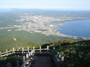 Mutsu City from Kamafuse-yama | |
 Flag  Seal | |
 Location of Mutsu in Aomori Prefecture | |
 Mutsu | |
| Coordinates: 41°17′34.2″N 141°11′1″E / 41.292833°N 141.18361°ECoordinates: 41°17′34.2″N 141°11′1″E / 41.292833°N 141.18361°E | |
| Country | Japan |
| Region | Tōhoku |
| Prefecture | Aomori |
| First official recorded | 862 AD |
| As city settled for Ōminato-tanabu | September 1, 1959 |
| Current city name changed | August 1, 1960 |
| Government | |
| • - Mayor | Sōichirō Miyashita |
| Area | |
| • Total | 864.16 km2 (333.65 sq mi) |
| Population (April 2020) | |
| • Total | 56,244 |
| • Density | 65/km2 (170/sq mi) |
| Time zone | UTC+9 (Japan Standard Time) |
| City symbols | |
| -Tree | Asunaro |
| -Flower | Rosa rugosa |
| -Bird | Whooper swan |
| Phone number | 0175-22-1111 |
| Address | 1-1-1, Kanaya, Mutsu-shi, Aomori-ken 035-8686 |
| Website | Official website |


Mutsu (むつ市, Mutsu-shi) is a city located in Aomori Prefecture, Japan. As of 1 April 2020, the city had an estimated population of 56,244, and a population density of 65 persons per km2, in 28,778 households.[1] The total area of the city is 864.16 square kilometers (333.65 sq mi), making it the largest municipality in Aomori Prefecture in terms of area.
Geography[]
Mutsu occupies most of Shimokita Peninsula and is bordered by Mutsu Bay to the south and Tsugaru Strait to the north, and is the northernmost city on the island of Honshū. The volcanic Osorezan Mountain Range extends across the northern portion of the city, and includes a number of caldera lakes. Parts of the city is within the limits of the Shimokita Hantō Quasi-National Park, including Mount Osore, Yagen Valley, and Taijima.[2]
Neighboring municipalities[]
- Aomori Prefecture
- Kazamaura
- Ōma
- Higashidōri
- Sai
- Yokohama
Climate[]
Mutsu has a rare oceanic climate (Köppen: Cfb) or warm-summer humid continental climate (Dfb) by 0 °C isoterm, the south of the city being the northern boundary of the hot-summer type (Dfa) in Aomori, disregarding rural areas in the west.[3][4] The city is characterized by warm summers and cool to cold winters with heavy snowfall. The average annual temperature in Mutsu is 7.2 °C. The average annual rainfall is 1339 mm with September as the wettest month. The temperatures are highest on average in August, at around 20.3 °C, and lowest in January, at around -4.6 °C.[5]
| hideClimate data for Mutsu, Aomori | |||||||||||||
|---|---|---|---|---|---|---|---|---|---|---|---|---|---|
| Month | Jan | Feb | Mar | Apr | May | Jun | Jul | Aug | Sep | Oct | Nov | Dec | Year |
| Average high °C (°F) | 1.1 (34.0) |
1.3 (34.3) |
4.8 (40.6) |
12.0 (53.6) |
17.5 (63.5) |
20.0 (68.0) |
23.5 (74.3) |
25.6 (78.1) |
22.1 (71.8) |
16.9 (62.4) |
10.3 (50.5) |
4.2 (39.6) |
13.3 (55.9) |
| Daily mean °C (°F) | −1.9 (28.6) |
−2.0 (28.4) |
1.1 (34.0) |
7.0 (44.6) |
12.1 (53.8) |
15.6 (60.1) |
19.5 (67.1) |
21.7 (71.1) |
17.6 (63.7) |
11.8 (53.2) |
6.2 (43.2) |
1.0 (33.8) |
9.1 (48.5) |
| Average low °C (°F) | −5.7 (21.7) |
−6.6 (20.1) |
−3.1 (26.4) |
2.3 (36.1) |
7.1 (44.8) |
11.8 (53.2) |
16.2 (61.2) |
18.3 (64.9) |
13.1 (55.6) |
6.3 (43.3) |
1.6 (34.9) |
−2.7 (27.1) |
4.9 (40.8) |
| Average precipitation mm (inches) | 104.5 (4.11) |
79.0 (3.11) |
77.1 (3.04) |
90.1 (3.55) |
81.0 (3.19) |
105.7 (4.16) |
124.8 (4.91) |
144.1 (5.67) |
166.7 (6.56) |
109.2 (4.30) |
117.5 (4.63) |
97.4 (3.83) |
1,297.1 (51.06) |
| Average snowfall cm (inches) | 140 (55) |
119 (47) |
52 (20) |
4 (1.6) |
0 (0) |
0 (0) |
0 (0) |
0 (0) |
0 (0) |
0 (0) |
14 (5.5) |
86 (34) |
415 (163.1) |
| Average relative humidity (%) | 75 | 75 | 72 | 71 | 74 | 83 | 86 | 85 | 81 | 74 | 72 | 75 | 77 |
| Mean monthly sunshine hours | 78.9 | 95.8 | 157.8 | 197.9 | 219.3 | 175.4 | 158.2 | 155.3 | 152.2 | 165.7 | 107.8 | 73.6 | 1,737.9 |
| Source: NOAA (1961-1990) [6] | |||||||||||||
Demographics[]
Per Japanese census data,[7] the population of Mutsu has declined over the past 40 years.
| Year | Pop. | ±% |
|---|---|---|
| 1920 | 34,129 | — |
| 1930 | 37,006 | +8.4% |
| 1940 | 45,887 | +24.0% |
| 1950 | 62,918 | +37.1% |
| 1960 | 65,880 | +4.7% |
| 1970 | 66,447 | +0.9% |
| 1980 | 71,567 | +7.7% |
| 1990 | 68,637 | −4.1% |
| 2000 | 67,022 | −2.4% |
| 2010 | 61,053 | −8.9% |
History[]
Mutsu was founded as September 1, 1959 through the merger of the former towns of Ōminato and Tanabu. Tanabu had been the location of a daikansho under the Morioka Domain in the Edo period, and was a resettlement and colonization zone for dispossessed ex-samurai of the defeated Aizu Domain after the Boshin War. The village of Ōminato was established with the creation of the modern municipalities system on 1 April 1889, and was raised to town status on November 10, 1928. Ōminato was a port town, and home to the Ōminato Guard District, a major base for the Imperial Japanese Navy until the end of World War II. The town and its military base were bombed repeatedly from the middle of July to middle of August 1945 during World War II. The base facilities were used by the United States Navy during the occupation of Japan, and (on a reduced scale) by the Japan Maritime Self Defence Force to date.
Ōminato merged with the adjacent town of Tanabe to form the city Ōminato-Tanabu (coupling of the names of two antecedent towns) on September 1, 1959; its name was changed to Mutsu in 1960. At the time, it was the only city with a hiragana name (むつ), which was adopted to avoid confusion with the original kanji word Mutsu (陸奥) which indicates the old province that covered most of the modern Tōhoku region.
On March 14, 2005, the towns of Kawauchi and Ōhata, and the village of Wakinosawa (all from Shimokita District) were merged into Mutsu.
Government[]
Mutsu has a mayor-council form of government with a directly elected mayor and a unicameral city legislature of 26 members. Mutsu, together with Shimokita District, contributes three members to the Aomori Prefectural Assembly. In terms of national politics, the city is part of Aomori 1st district of the lower house of the Diet of Japan.
Economy[]
The economy of Mutsu is heavily dependent on agriculture, forestry and fishing, especially scallop aquaculture in Mutsu Bay. The city is also the location for various facilities of the Japan Atomic Energy Agency, and was the home port for the nuclear powered research vessel Mutsu, until its decommissioning in 1997.
Education[]
Mutsu has 13 public elementary schools and nine middle schools operated by the city government, and three public high schools operated by the Aomori Prefectural Board of Education. The prefecture also operates two special education schools for the handicapped.
High schools[]
- Tanabu High School
- Ōminato High School
- Mutsu Technical High School
Transportation[]
Railway[]
![]() East Japan Railway Company (JR East) - Ōminato Line
East Japan Railway Company (JR East) - Ōminato Line
Highway[]
International relations[]
Local attractions[]
Noted people from Mutsu[]
- Yuya Asahina, manga artist
- Yuzo Kawashima, movie director
- Ryu Fujisaki, manga artist
- Fumie Hosokawa, actress and gravure model
- Kenichi Matsuyama, actor
References[]
- ^ Mutsu City official statistics
- ^ "Mutsu Shimokita Tourist Information". Mutsu City Tourist Association. 2020. Retrieved 17 November 2020.
- ^ "Mutsu Climate Mutsu Temperatures Mutsu Weather Averages". www.mutsu.climatemps.com. Retrieved 2019-03-07.
- ^ "Interactive Asia Koppen-Geiger Climate Classification Map". www.plantmaps.com. Retrieved 2019-03-07.
- ^ Mutsu climate data
- ^ "Mutsu Climate Normals 1961-1990". National Oceanic and Atmospheric Administration. Retrieved December 29, 2012.
- ^ Mutsu population statistics
External links[]
![]() Media related to Mutsu, Aomori at Wikimedia Commons
Media related to Mutsu, Aomori at Wikimedia Commons
- Official Website (in Japanese)
| show Authority control |
|---|
- Mutsu, Aomori
- Cities in Aomori Prefecture
- Port settlements in Japan
- Populated coastal places in Japan