Sirjan
Sirjan
سيرجان | |
|---|---|
City | |
 | |
 Sirjan | |
| Coordinates: 29°27′07″N 55°40′53″E / 29.45194°N 55.68139°ECoordinates: 29°27′07″N 55°40′53″E / 29.45194°N 55.68139°E | |
| Country | |
| Province | Kerman |
| County | Sirjan |
| Bakhsh | Central |
| Elevation | 1,730 m (5,680 ft) |
| Population (2016 Census) | |
| • Urban | 199,704 [1] |
| Time zone | UTC+3:30 (IRST) |
| • Summer (DST) | UTC+4:30 (IRDT) |
| Website | sirjan municipality |

Sirjan (Persian: سيرجان, also Romanized as Sīrjān; formerly Sa‘īdābād)[2] is a city and the capital of Sirjan County, Kerman Province,in the South of Iran. According to the 2016 census, its population was 324,103 in 95,357 families.[3] Sirjan is located 960 kilometers from the Iranian capital of Tehran, and 175 kilometers from the provincial capital of Kerman. It is known for its pistachios, Kilim and its wind towers, locally known as Bādgir-e Chopoqi (calumet louver).
Climate[]
At 1730m, it is situated in a depression between the southern Zagros Mountains to the west and the Kuh-e Bidkhan massif to the east.
Once containing extensive and thick forests, at present the total area of counties forests which are scattered throughout the region in a natural reserved area is around 4,500 hectares containing trees and shrubs such as turpentines, conifers and dwarf maples amongst many others.
Culture[]
Sirjan is a historic city with culture. There are historical and cultural monuments in the city of Sirjan.
Historical sites, ancient artifacts and tourism[]
This city was established in the Sasanian era and has several mineral sources including coal, iron, copper, stone and gold.
Today the city is witnessing great economic growth mainly due to its industrial sector as well as its key location in the heart of southern Iran. With established strategic roads for domestic supply of goods as well as great access to Bandar E Abbas for exportation of goods.
Sirjan campus of Kerman University of Medical Sciences is in Sirjan, called Sirjan School of Medical Sciences and is affiliated to Kerman University of Medical Sciences is established in 2010 with more than 500 undergraduate students.
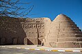
Chopoqi Windcatcher[]
The Chopoqi Windcatcher is a historical Windcatcher belongs to the Pahlavi dynasty and is located in Sirjan, Kerman Province in Iran.[4][5]
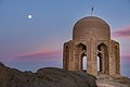
Tomb of Mire Zobeyr[]
The Tomb of Mire Zobeyr is a historical Tomb belongs to the Ilkhanate and is located in Sirjan County, Kerman Province in Iran.[6][7]
Tomb of Shah Firooz[]
The Tomb of Shah Firooz is a historical Tomb belongs to the 9th century AH and is located in Sirjan, Kerman Province in Iran.[8][9]
Sang Castle[]
Sang Castle is a historical castle located in Sirjan County in Kerman Province, The longevity of this fortress dates back to the Sasanian Empire.[10][11]
Name[]
The first name of Sirjan was Sirgan or Samangan. For the sake of the Arabs, the change was made in the pronunciation of it. Afterwards, it turned into Sirjan. Sirjan is an old city with a very historic history means "being
Industry[]
Sirjan has several of the largest companies within its 100 km radius. Gole Gohar Iron Ore Mine is the countries' largest with estimated $2.8 billion valuation. PolyTech of Sirjan Co., with over 400 employees, is the largest domestic manufacturer in the city's Industrial Town. Gold Iran under license from LG is also a major player in the city with 1,200 employees and a location in the Special Economic Zone. LG assembles most of its Iranian market digital products in this location.
Transportation[]
The city is served by the Sirjan Airport (IATA: SYJ, ICAO: OIKY). The city also has a railway station near the airport.
Future plan/development[]
Sirjan Petrochemical Co. is currently gathering its second round of investments in order to establish the first Petrochemical Facility in the Kerman Province.
Mereekh Market (Part of Mereekh Food Ind. Group) plans to develop the first multi-store shopping center in the city's downtown area. The estimated project is reported to cost $20M.
Special Economic Zone, Industrial Town #1, and Industrial Town #2 continue to grow its factory base.
Gallery[]

Heavy rain in sirjan

The Stone Garden in Sirjan

Sirjan county


References[]
- ^ https://www.amar.org.ir/english
- ^ Sirjan can be found at GEOnet Names Server, at this link, by opening the Advanced Search box, entering "-3085890" in the "Unique Feature Id" form, and clicking on "Search Database".
- ^ "Census of the Islamic Republic of Iran, 1385 (2006)" (Excel). Statistical Center of Iran. Archived from the original on 2011-11-11.
- ^ "يخدان تاريخي "كوثر" گناباد به مركز گردشگري تبديل ميشود". Islamic Republic News Agency. Retrieved 22 March 2021.
- ^ ""بادگیر چپقی" سیرجان مرمت و بازسازی میشود". Iranian Students News Agency. Retrieved 22 March 2021.
- ^ "گزارش تصویری وتحلیل فنی از بنای تاریخی میر زبیر". sinapress.ir. Retrieved 22 March 2021.
- ^ "آرامگاه میر زبیر سیرجان". seeiran.ir. Retrieved 22 March 2021.
- ^ "خاطره نوروز در سیرجان، شهر جهانی گلیم". Islamic Republic News Agency. Retrieved 22 March 2021.
- ^ "سیرجان، شهر خاطرات شیرین مسافران نوروزی". Iranian Students News Agency. Retrieved 22 March 2021.
- ^ "قلعه سنگ دژی مستحکم و تاریخی در سیرجان+تصاویر". www.dana.ir. Retrieved 14 February 2021.
- ^ "قلعه سنگی سیرجان". seeiran.ir. Retrieved 14 February 2021.
| hide | ||
|---|---|---|
| Capital |  | |
| Counties and cities | ||
| Sights |
| |
| Places | ||
| Authority control |
|---|
- Sirjan County
- Cities in Kerman Province
- Populated places in Sirjan County
- Sasanian cities