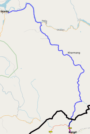
Skardu–Kargil Road
| Skardu–Kargil Road سکردو – کرگل سڑک | |
|---|---|
 | |
| Route information | |
| Maintained by Planning & Development Department | |
| Length | 126 km (78 mi) |
| Restrictions | Line of Control |
| Major junctions | |
| From | Skardu |
| To | Kharmang |
| Highway system | |
The Skardu–Kargil Road (Urdu: سکردو – کرگل سڑک) is a 126-kilometre (78 mi) provincial highway in the Pakistani-administered territory of Gilgit–Baltistan, running from the city of Skardu to the Line of Control with the Indian-administered territory of Ladakh, via the Kharmang Valley.[1] The original road continued to run until the town of Kargil, but has been closed since 1948.[2]
History[]
The road from Skardu to Kargil was part of the ancient Silk Road.[3][better source needed]
Prior to the Indo-Pakistani War of 1947–1948, the regions of Kargil, Leh and Baltistan constituted the Ladakh Wazarat within the princely state of Jammu and Kashmir in British India. Following the end of the First Indo-Pakistani War, Kargil and Baltistan came under the control of India and Pakistan respectively. The 1949 United Nations-mandated ceasefire line separated the two regions; many families still trace their immediate ancestors on the other side of the de facto border.[3]
Many people from both sides of the Line of Control seek to have the road re-opened to traffic, partly on humanitarian grounds.[4][5]
See also[]
References[]
- ^ http://www.dailytimes.com.pk/opinion/01-Sep-2015/opening-the-kargil-skardu-road
- ^ Khan, M Ismail (9 May 2006). "Political debris blocking the Skardu-Kargil road". The News. Pakistan. Retrieved 26 October 2020.
- ^ a b Haidar Ali Askary, Kargil-Skardu Road: Only Connect, Greater Kashmir, 24 May 2015.
- ^ https://www.dawn.com/news/198840/refugees-seek-opening-of-skardu-kargil-road[bare URL]
- ^ https://www.dawn.com/news/615159[bare URL]
This article on a road in Pakistan is a stub. You can help Wikipedia by . |
- Highways in Gilgit-Baltistan
- Roads in Gilgit-Baltistan
- Skardu District
- Kharmang District
- Asia road stubs
- Pakistan transport stubs