Slapy (Prague-West District)
Slapy | |
|---|---|
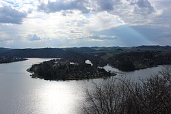
 Slapy Reservoir and Slapy village | |
 Flag  Coat of arms | |
 Slapy Location in the Czech Republic | |
| Coordinates: 49°48′55″N 14°23′46″E / 49.81528°N 14.39611°ECoordinates: 49°48′55″N 14°23′46″E / 49.81528°N 14.39611°E | |
| Country | |
| Region | Central Bohemian |
| District | Prague-West |
| First mentioned | 1292 |
| Area | |
| • Total | 20.24 km2 (7.81 sq mi) |
| Elevation | 358 m (1,175 ft) |
| Population (2021-01-01)[1] | |
| • Total | 866 |
| • Density | 43/km2 (110/sq mi) |
| Time zone | UTC+1 (CET) |
| • Summer (DST) | UTC+2 (CEST) |
| Postal code | 252 08 |
| Website | www |
Slapy is a municipality and village in Prague-West District in the Central Bohemian Region of the Czech Republic. It has about 900 inhabitants. It is located on the shore of Slapy Reservoir, which is the 6th largest dam in the country by area.
References[]
| Wikimedia Commons has media related to Slapy (Prague-West District). |
Categories:
- Populated places in Prague-West District
- Villages in Prague-West District
- Prague-West geography stubs
