Smila
Smila
Сміла | |
|---|---|
Town | |
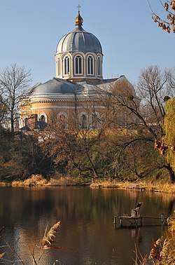 The Cathedral of the Intercession of the Theotokos of Smila | |
 Flag  Coat of arms | |
 Smila Location of Smila | |
| Coordinates: 49°12′42″N 31°52′23″E / 49.21167°N 31.87306°ECoordinates: 49°12′42″N 31°52′23″E / 49.21167°N 31.87306°E | |
| Country | |
| Oblast | |
| Raion | Cherkasy Raion |
| Founded | 1542 |
| City status | 1926 |
| Government | |
| • Mayor | Mr. Serhiy Ananko |
| Area | |
| • Land | 39.85 km2 (15.39 sq mi) |
| Elevation | 101 m (331 ft) |
| Population (2021) | |
| • Total | 66,475 |
| [1] | |
| Time zone | UTC+2 (EET) |
| • Summer (DST) | UTC+3 (EEST) |
| Postal code | 20700 |
| Area code(s) | +380 4733 |
| Sister cities | Rzhev, Newton, Iowa, Vatutine, Irpin |
| Website | smila-rada.gov.ua |


Smila (Ukrainian: Сміла [ˈs⁽ʲ⁾milɐ]) is a city located on Dnieper Upland near the Tyasmyn River, in Cherkasy Raion, Cherkasy Oblast of Ukraine. It hosts the administration of , one of the hromadas of Ukraine.[2] Population: 66,475 (2021 est.)[1]
Climate[]
Climate in the city is moderate continental. Winters are cold with frequent snowing. Summers are warm and can be hot in July, with little possibility of rain. Periods of temperatures higher than +10 endure up to 170 days. Annual precipitation level is 450–520 mm. Dnieper tributary Tyasmyn River flows through the city.[3]
History[]
Foundation of Smila[]
Smila and its neighbourhood have been settled since the ancient times. Archeologists discovered a number of ruins of ancient settlements and numerous mounds located in different parts of Smila and near the city. Two biggest ancient settlements and 44 mounds were first researched during 1879–1883 years by O. O. Bobrynsky, grandson of Smila owner, Count Olexiy Olexiyovich Bobrynsky. These findings belong partly to the Stone Age and partly to the Bronze Age.
Official foundation date of Smila is 1542. Grand Duchy of Lithuania documents tell us that settlement Yatzkove-Tyasmyno was founded on a hamlet place in 1542. The modern name of the city has been known since the first half of the 17th century.
City's name is connected with a local legend first recorded by Count L. O. Bobrynsky: "An unknown girl led warriors through a heavy swamp showing a route to the enemy. The battle was very bloody. They killed a lot of enemies there but they couldn’t save the brave girl. They buried her near Tyasmyn and called her Smila.[4] Then warriors honoured her in the city’s name."
1569 - 1793[]
After the Union of Lublin in July 1569, it was a settlement of the Polish–Lithuanian Commonwealth.
During 1648 — 1667 this squadron town belonged to Chyhyryn Regiment. In 1654 Russian tsar gave Pereyaslav colonel Pavlo Teteria possession of the town. During 1658-1659 changed Teterya as the owner. Chudniv treaty of 1660 renewed Polish power on this land. Smila became an ownership of Stanislav Koniecpolski as part of Polish–Lithuanian Commonwealth. Constant wars between Ukrainian Cossacks, Polish owners, Tatars, Turks, Russians and Swedes [5] led to demolition of Smila. (More The Ruin) Further owners of Smila, princes Lubomirski built a wooden castle with arbor and palisade around the whole city in 1742. During 1730s-1760s parts of the population of Smila took part in Haidamaka movement. In 1787 prince Xaveriy Lubomirski sold lands around Smila to Russian prince Potyomkin. Six years later Smila became a property of Potyomkin's nephew, Count Alexander Samoylov. Two years later population of Smila was 1747 people with 50 crafters, 9 shoemakers, 6 weavers, 8 tailors. Others were peasants.
1793 - 1917[]
After second Partition of Poland Smela was a township which subordinated to Cherkassy county of Kyiv Governorate of the Russian Empire. In 1838 a large sugar plant was built here.
Since 1917[]
City since 1926.
During the World War II it was occupied by Nazi German troops since August 1941 until January 1944.
In January 1989 the population was 79 449 people.[6][7]
In January 2013 the population was 68 636 people.[8]
Until 18 July 2020, Smila was designated as a city of oblast significance and served as the administrative center of Smila Raion though it did not belong to the raion. Settlements of and Irdynivka were subordinated to Smila city council. As part of the administrative reform of Ukraine, which reduced the number of raions of Cherkasy Oblast to four, the city was merged into Cherkasy Raion.[9][10]
Economy[]
The economic emphasis is on mechanical engineering, and the food industry is also of importance.
Smila is the biggest transport center of the region as a huge is located here.
Smila, where the Kyiv–Dnipro and Odessa–Russia rail routes cross, is one of the most important railway junctions in Ukraine. The large station at the junction is named after Ukraine's national poet and artist, Taras Shevchenko.
Gallery[]

Female gymnasium building

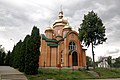
Assumption Church in Smila

Church of the Holy Virgin

Museum of Local History

Technical Institute for Sugar Industry in Smila

Bank building in Smila

Shevchenko district

Railway station

Railway bridge in Smila

Tiasmyn River in Smila


Sister cities[]
Smila is currently twinned with:
 Newton, Iowa, United States
 Rzhev, Russia
References[]
- ^ a b "Чисельність наявного населення України (Actual population of Ukraine)" (PDF) (in Ukrainian). State Statistics Service of Ukraine. Retrieved 11 July 2021.
- ^ "Смілянська територіальна громада" (in Ukrainian). decentralization.gov.ua.
- ^ "Сміла".
- ^ It means - brave
- ^ "Даниловский монастырь в Москве / Православие.Ru".
- ^ Всесоюзная перепись населения 1989 г. Численность городского населения союзных республик, их территориальных единиц, городских поселений и городских районов по полу
- ^ Смела // Большой энциклопедический словарь (в 2-х тт.). / редколл., гл. ред. А. М. Прохоров. том 2. М., "Советская энциклопедия", 1991. стр.367
- ^ Чисельність наявного населення України на 1 січня 2013 року. Державна служба статистики України. Київ, 2013. стор.106
- ^ "Про утворення та ліквідацію районів. Постанова Верховної Ради України № 807-ІХ". Голос України (in Ukrainian). 2020-07-18. Retrieved 2020-10-03.
- ^ "Нові райони: карти + склад" (in Ukrainian). Міністерство розвитку громад та територій України. 17 July 2020.
- (in Ukrainian) (1972) Історія міст і сіл Української CCP - Черкаська область (History of Towns and Villages of the Ukrainian SSR - Cherkasy Oblast), Kyiv.
External links[]
- (in Ukrainian) Official city website
- (in Ukrainian) Unofficial city website
Administrative center: Smila, Ukraine | ||
| Cities | ||
| Authority control |
|---|
- Cities in Cherkasy Oblast
- Cherkassky Uyezd
- Shtetls
- Cities of regional significance in Ukraine