Chyhyryn
Chyhyryn
Чигирин | |
|---|---|
 View of Chyhyryn from the city's Castle Hill. | |
 Flag  Coat of arms | |
 Chyhyryn Location of Chyhyryn | |
| Coordinates: 49°04′38″N 32°38′57″E / 49.07722°N 32.64917°ECoordinates: 49°04′38″N 32°38′57″E / 49.07722°N 32.64917°E | |
| Country | |
| Oblast | |
| Raion | Cherkasy Raion |
| City rights | 1592 |
| Government | |
| • Mayor | Serhiy Oleksiiovych Tymchenko |
| Area | |
| • Total | 14 km2 (5 sq mi) |
| Elevation | 124 m (407 ft) |
| Population (2021) | |
| • Total | 8,664 |
| • Density | 854/km2 (2,210/sq mi) |
| Postal code | 20900-20906 |
| Area code(s) | +380 4730 |


Chyhyryn (Ukrainian: Чигири́н, pronounced [tʃɪɦɪˈrɪn]) is a city and historic site located in Cherkasy Raion of Cherkasy Oblast of central Ukraine. From 1648 to 1669 the city was a Hetman residence. After a forced relocation of the Ruthenian Orthodox metropolitan see from Kyiv in 1658, it became a full-fledged capital of the Cossack Hetmanate. Chyhyryn also became a traditional place for the appointment to the office of Hetman of Zaporizhian Host. It hosts the administration of , one of the hromadas of Ukraine.[1] Population: 8,664 (2021 est.)[2]
Names[]
Chyhyryn (Ukrainian: Чигирин) or Chigirin (Russian: Чигири́н) Polish: Czehryń, Turkish: Çigirin or Çehrin.
Location[]
The city is on the banks of Tiasmyn River and lies at an altitude of 124 metres above mean sea level. Minor industries, such as food and furniture factories, are the basis of the town economy in the 21st century.
History[]
The area (1320–1569) had been part of the Grand Duchy of Lithuania. It was ceded to the Polish–Lithuanian Commonwealth (in the Kijów Voivodeship [Kyiv or Kiev] of the Crown of Poland) before the Union of Lublin. It was granted Magdeburg Rights in 1592 by Sigismund III Vasa.

Chyhyryn is first mentioned as a fortified Cossack winter station. In 1638, Bohdan Khmelnytsky became its starosta (regional leader), and in 1648 it became the newly elected Hetman's residence and the capital of the Cossack state, the Zaporozhian Host. During the Russo-Turkish War (1676–1681) it was the center of two bloody campaigns (1675–76 and 1677–78). In 1678 the castle of Chyhyryn was blown up by the retreating Russian garrison that was stationed there, while the Turkish forces sacked the rest of the city. After this, it gradually lost its significance. It remained the center of the Chyhyryn regiment until 1712 and upon the final incorporation into the Russian Empire (1793) it became part of the Kyiv region.
In 1917 a congress of Free Cossacks took place in Chyhyryn. At that congress by tradition Pavlo Skoropadsky was elected as the Hetman of the Cossacks (later in 1918 in Kyiv, he was elected the Hetman of Ukraine as well).
During World War II, Chyhyryn was occupied by the German Army from August 7, 1941 to December 12, 1943.
In 1989 the population of the city was 12 853 people.[3]
Until 18 July 2020, Chyhyryn served as an administrative center of Chyhyryn Raion. The raion was abolished in July 2020 as part of the administrative reform of Ukraine, which reduced the number of raions of Cherkasy Oblast to four. The area of Chyhyryn Raion was merged into Cherkasy Raion.[4][5]
Climate[]
| hideClimate data for Chyhyryn (1981–2010) | |||||||||||||
|---|---|---|---|---|---|---|---|---|---|---|---|---|---|
| Month | Jan | Feb | Mar | Apr | May | Jun | Jul | Aug | Sep | Oct | Nov | Dec | Year |
| Average high °C (°F) | −0.9 (30.4) |
−0.1 (31.8) |
5.5 (41.9) |
14.4 (57.9) |
21.3 (70.3) |
24.3 (75.7) |
26.3 (79.3) |
25.9 (78.6) |
20.0 (68.0) |
13.0 (55.4) |
5.0 (41.0) |
0.4 (32.7) |
12.9 (55.2) |
| Daily mean °C (°F) | −3.5 (25.7) |
−3.1 (26.4) |
1.7 (35.1) |
9.4 (48.9) |
15.9 (60.6) |
19.2 (66.6) |
21.2 (70.2) |
20.4 (68.7) |
14.9 (58.8) |
8.8 (47.8) |
2.3 (36.1) |
−2.1 (28.2) |
8.8 (47.8) |
| Average low °C (°F) | −6.1 (21.0) |
−5.9 (21.4) |
−1.5 (29.3) |
4.8 (40.6) |
10.4 (50.7) |
14.3 (57.7) |
16.1 (61.0) |
15.0 (59.0) |
10.4 (50.7) |
5.4 (41.7) |
−0.2 (31.6) |
−4.4 (24.1) |
4.9 (40.8) |
| Average precipitation mm (inches) | 34.4 (1.35) |
32.9 (1.30) |
35.5 (1.40) |
36.7 (1.44) |
49.7 (1.96) |
77.1 (3.04) |
65.2 (2.57) |
54.2 (2.13) |
55.9 (2.20) |
42.1 (1.66) |
39.4 (1.55) |
37.0 (1.46) |
560.1 (22.05) |
| Average precipitation days (≥ 1.0 mm) | 7.4 | 7.1 | 7.3 | 7.0 | 7.2 | 8.5 | 7.1 | 6.3 | 6.5 | 5.7 | 6.8 | 7.4 | 84.3 |
| Average relative humidity (%) | 83.5 | 80.8 | 76.6 | 66.9 | 63.2 | 68.0 | 68.0 | 66.4 | 71.9 | 76.9 | 84.0 | 85.1 | 74.3 |
| Source: World Meteorological Organization[6] | |||||||||||||
Notable people[]
- Georgy Danilov, linguist
Landmarks[]
The Trinity Monastery, built near Chyhyryn in 1627, was later destroyed by the Soviet authorities. Other historical landmarks, such as the town hall and Khmelnytsky's palace, did not survive either. After Ukraine regained independence, Hetman's residence was restored and became a museum.
Gallery[]
Main square of Chyhyryn
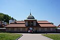
Entrance of the restored Bohdan Khmelnytskyi residence

Bohdan Khmelnytskyi residence

St. Peter and St. Paul Church in Chyhyryn
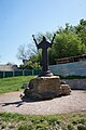
A statue near the church

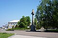
Taras Shevchenko monument in Chyhyryn

View on Bohdan Khmelnytskyi Museum
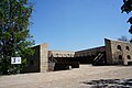
Remnants of Chyhyryn Fortress on the Castle Hill

Bohdan Khmelnytskyi monument in Chyhyryn


International relations[]
Twin towns — Sister cities[]
Chyhyryn is twinned with:
| City | Country | Year of Signing |
|---|---|---|
| Sebastopol, California | 1993 |
References[]
- ^ "Чигиринская громада" (in Russian). Портал об'єднаних громад України.
- ^ "Чисельність наявного населення України (Actual population of Ukraine)" (PDF) (in Ukrainian). State Statistics Service of Ukraine. Retrieved 11 July 2021.
- ^ Всесоюзная перепись населения 1989 г. Численность городского населения союзных республик, их территориальных единиц, городских поселений и городских районов по полу
- ^ "Про утворення та ліквідацію районів. Постанова Верховної Ради України № 807-ІХ". Голос України (in Ukrainian). 2020-07-18. Retrieved 2020-10-03.
- ^ "Нові райони: карти + склад" (in Ukrainian). Міністерство розвитку громад та територій України.
- ^ "World Meteorological Organization Climate Normals for 1981–2010". World Meteorological Organization. Archived from the original on 17 July 2021. Retrieved 17 July 2021.
External links[]
- Chyhyryn in the Encyclopedia of Ukraine
- Soviet topographic map 1:100,000
 Media related to Chyhyryn at Wikimedia Commons
| show Authority control |
|---|
- Cities in Cherkasy Oblast
- Chigirinsky Uyezd
- Kiev Voivodeship
- Former national capitals
- Former capitals of Ukraine
- Cities of district significance in Ukraine
- Cossack Hetmanate