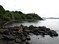
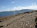
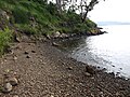
Smooth Island (Tasmania)
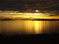
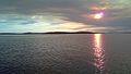
 Smooth Island sunset | |
 Smooth Island Location in Tasmania | |
| Geography | |
|---|---|
| Location | Norfolk Bay |
| Coordinates | 42°56′24″S 147°46′48″E / 42.94000°S 147.78000°ECoordinates: 42°56′24″S 147°46′48″E / 42.94000°S 147.78000°E |
| Archipelago | Sloping Island Group |
| Area | 59.31 ha (146.6 acres) |
| Coastline | 3.38 km (2.1 mi) |
| Highest elevation | 44 m (144 ft) |
| Administration | |
Australia | |
| State | Tasmania |
| Additional information | |
| Time zone |
|

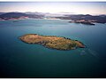
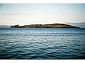
Smooth Island, is a privately owned island with an area of 59.31 ha (146.6 acres)[1] lying close to the south-eastern coast of Tasmania, Australia. The island is part of the Sloping Island Group situated in Norfolk Bay and surrounded by the Tasman and Forestier Peninsulas.[1] The towns Dunalley and Murdunna are nearby. Smooth Island differs from other Tasmanian islands as it has an unencumbered freehold title down to the high-water mark.
Administration[]
For administrative purposes, the island is within the Tasman Council, the land district of Pembroke, the legislative council of Rumney and the electorate of Lyons at state and federal levels.[citation needed] It lies within the Fire Management Area Committee Boundary (FMAC) of 'East Coast'.[citation needed]
Smooth Island is privately owned; it has a freehold title with no covenants. In 2014 Smooth Island was gazetted as a Private Forest Timber Reserve.[2] The coast line 200 metres (660 ft) from the Smooth Island waterline has been classified Zone 23 (Environmental management) under the Tasman Interim Planning Scheme 2015.[3][4]
Access[]
Smooth island is private property to the coastal high-water mark; unauthorised public access, including mooring of vessels, is prohibited. Subject to authorisation, Smooth Island is easily accessible by boat and helicopter. The island's terrain is suited to the construction of a small airstrip.
Services[]
The island receives radio coverage from ABC Local Radio (936 AM), 3G mobile phone coverage from Telstra and wireless coverage from the National Broadband Network. The table below outlines the nearest services and facilities to Smooth Island.
| Service type | Name | Address | Coordinates | Distance by air | Distance by boat | Distance by road from Murdunna | showReference |
|---|
Recreational fishing[]
"All waters 200 metres seaward from the low water mark of Smooth Island: Shark Refuge Area. No taking of shark, skates or rays, except elephantfish. Where permitted, graball nets must not be set for more than 2 hours and can only be set from sunrise until one hour before sunset. No mullet nets. No set lines (ong lines and drop lines)."[13]
Geography[]
Smooth Island lies 2.24 km (1.39 mi) from both Dunbabin Point[14] and on the mainland, and 2.3 km (1.4 mi) from King George Island, measured from the nearest coastlines.
The island has two hilly peaks separated by a saddle.[note 19] The height above sea level of the North peak, South peak and saddle are 43 metres (141 ft), 40 metres (130 ft) and 30 metres (98 ft) respectively.[note 20][note 21]
Climate[]
Smooth island's climate is classified Cfb under the Köppen Climate Classification.
| hideClimate data for Hobart International Airport (26 km (16 mi) from Smooth Island) | |||||||||||||
|---|---|---|---|---|---|---|---|---|---|---|---|---|---|
| Month | Jan | Feb | Mar | Apr | May | Jun | Jul | Aug | Sep | Oct | Nov | Dec | Year |
| Average high °C (°F) | 22.6 (72.7) |
22.3 (72.1) |
20.8 (69.4) |
18.1 (64.6) |
15.3 (59.5) |
12.9 (55.2) |
12.5 (54.5) |
13.5 (56.3) |
15.4 (59.7) |
17.3 (63.1) |
19 (66) |
20.7 (69.3) |
17.5 (63.5) |
| Average low °C (°F) | 12 (54) |
12.1 (53.8) |
10.8 (51.4) |
8.8 (47.8) |
6.6 (43.9) |
4.6 (40.3) |
4.1 (39.4) |
4.7 (40.5) |
6.1 (43.0) |
7.5 (45.5) |
9.2 (48.6) |
10.8 (51.4) |
8.1 (46.6) |
| Average precipitation mm (inches) | 40.8 (1.61) |
35.9 (1.41) |
36.1 (1.42) |
42.2 (1.66) |
35.6 (1.40) |
32.5 (1.28) |
43.8 (1.72) |
47.1 (1.85) |
41.6 (1.64) |
46.3 (1.82) |
44.9 (1.77) |
52.6 (2.07) |
499.4 (19.65) |
| Source: Australian Bureau of Meteorology (1958–2015) [15] | |||||||||||||
Ecosystem[]
The following fauna and flora have been observed on Smooth Island:[16]
| show List of species
|
|---|

Geology[]

Smooth Island consists of diabase or dolerite rock, a subvolcanic intrusion that probably occurred from 56 to 33.9 million years ago during the Eocene epoch of the Cenozoic era.[17] A geological survey identified consolidated, brownish, fine-grained quartz sandstone occurring on the island's north-east coastline at approximately 2 metres (6.6 ft) above sea level, covered by sand. It was said to be similar to the sandstone samples retrieved from South Arm that contained numerous fossils but no fossils were found in the samples taken from Smooth Island.[18][19] The western aspect of the island contains dolerite (tholeiitic) with locally developed granophyre from the Jurassic period. The water table is classified as a surficial sediment aquifer (porous media – unconsolidated).[20]
Because the island predominantly has a sloping hard rock shore, there is little vulnerability to flooding or erosion due to a rise in sea level.[21] A coastal acid sulfate soil analysis produced a result of "extremely low" along the north and north-east side of the island.[21]
Marine ecology[]


Smooth Island is surrounded by a low-profile reef. A region of gravel or hard sand extends from the reef on the eastern coast towards King George Island and King George Sound. The reef on the western coast is surrounded by sand and a body of silt approaches the south-west coast of the island. Between Smooth Island and King George Island lies a dense bed of seagrass (Halophila australis) and eelgrass (Zostera tasmanica) covering about 12.5 hectares (31 acres).[22] Studies have found dense populations of South Australian cobbler (Gymnapistes marmoratus) within this region because this fish prefers patchy beds of eelgrass.[23] The island's east coast has the densest concentration of Little weed whiting (Neoodax balteatus) in Norfolk Bay; an assessment in 1995–1996 revealed that 88% of the fish caught were of the species Little Rock Whiting (Neoodax balteatus) and Bridled Leatherjacket (Acanthaluteres spilomelanurus).[24]
A species of red algae (Rhabdonia verticillata)[25][26] has been found close to the island.[27] The fish species flathead, trumpeter, perch, cod and Australian salmon can be found in the waters immediately surrounding the island. Dolphins are frequently sighted and killer whales (Orcinus orca) [28] are infrequently sighted near the island.[29][30] The Spotted handfish and the Live-bearing Seastar (Parvulastra vivipara) are threatened marine species that may be present in the waters surrounding Smooth Island.Cite error: A <ref> tag is missing the closing </ref> (see the help page).
A killer whale was identified 1 km (0.62 mi) north-east of the current lighthouse position. Several humpback whales were spotted near Smooth Island in June 2017.[31]
Ecological rehabilitation[]
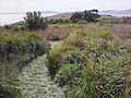
The terrestrial ecosystem of Smooth Island has been damaged by overgrazing and slashing-and-burning,[32] and through the commercial hunting of wildlife.[33] The island's natural vegetation has been largely displaced by exotic grass, thistle, bracken, scattered eucalypts and African boxthorn bushes. Between 0.86 ha (2.1 acres)[34] and 18 ha (44 acres) of shearwater rookeries are present on Smooth Island and the impact of repeated fires on these habitats has been studied.[32] The island' current owners intend to systematically restore its native ecosystem. Since March 2014, a diverse range of native Tasmanian flora have been planted throughout the island.[35] Remnant eucalypts are also expected to seed on the island's south-east coast since grazing has ceased.
History[]
Toponymy[]
Matthew Flinders discovered the island on 15 December 1798 and named it "Smooth Island" on his contemporaneous maps[36][37] but the island does not appear on his 1814 map.[38] In 1824 Thomas Scott referred to the island as "Garden Island" on his maps. The origins of this are not entirely clear, and other sources are inconclusive about the above assertions.[39] and state that the island was first named on a map by "Cross (1830)" and "Frankland" (1837)", before stating several pages later that the island was first named "Smooth Island".
According to a 1911 newspaper article, the island "is not named in the map of D'Entrecasteaux, even though it was marked".[40] During the early 21st century, Smooth Island was occasionally listed as "Lot 1 Norfolk Bay, Dunalley TAS 7177" on some real-estate classifieds.[41]
Much confusion exists about the names of many of the islands in South East Tasmania. Garden Island has become an alternative name for both Green Island[42] and Smooth Island. A newspaper article from 1836 refers to a Garden Island in the Pembroke Land District.[43][44]
Structures[]

A survey of Smooth Island was completed on 14 July 1863; it reveals the presence of the original jetty, a spring and a guano excavation site on the island.[citation needed] Until 2014, a lighthouse with the international marker identifier K 3621.2 was present on Smooth Island; moved it following demands by the island's owners.[note 22][45][note 23][46]
Potential uses[]
Smooth Island's south and west coasts have alkaline soil while the east slope has acidic soil.[47] The crops with the greatest yield potential are as follows:[47]
- Table wine grapes[note 24]
- Sparkling wine grapes[note 25]
- Industrial hemp[note 26]
- Pyrethrum[note 26]
- Blueberries [note 27]
- Phosphate mining: on 13 October 1941, the viability of mining phosphate on Smooth Island was assessed but was determined to not be viable.[48]
Artwork[]

Smooth Island has been the subject of two notable paintings: Michael Weitnauer's Norfolk Bay[49][50] and Dale Frank's "Dunalley, Smooth Island".[51] It has been mentioned in poems such as "" by Kathryn Lomer:[52]
I could lose or find myself
in this private Bermuda triangle-
Connelly's Bay, Lime Bay, Smooth Island;
In the dusk Smooth Island's navigation light
begins to blink its code name
to sailors bound for Dunalley[52]
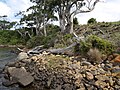
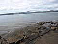
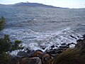
Gallery[]


See also[]
- List of islands of Tasmania
Footnotes[]
- ^ Sommers Bay Road, Murdunna, Tas 7173
- ^ 42°56′45″S 147°51′18″E / 42.945952°S 147.855128°E
- ^ Tiger Head Rd, Dodges Ferry, Tas 7173
- ^ 42°51′27″S 147°36′41″E / 42.857603°S 147.611366°E
- ^ 52 Carlton Beach Rd, Dodges Ferry, Tas 7173
- ^ 42°51′28″S 147°37′04″E / 42.857818°S 147.617753°E
- ^ 48 Liverpool St, Hobart, Tas 7000
- ^ 42°52′48″S 147°19′46″E / 42.879905°S 147.329534°E
- ^ 126 Arthur Hwy, Dunalley, Tas 7177
- ^ 42°53′14″S 147°48′37″E / 42.887223°S 147.810238°E
- ^ Jump up to: a b 17 Constance St, Dunalley, Tas 7177
- ^ Jump up to: a b 42°53′23″S 147°48′21″E / 42.889719°S 147.805765°E
- ^ 119 Arthur Hwy, Dunalley, Tas 7177
- ^ 42°53′14″S 147°48′43″E / 42.887226°S 147.812031°E
- ^ 168 Arthur Hwy, Dunalley, Tas 7177
- ^ 42°53′22″S 147°48′22″E / 42.889480°S 147.806124°E
- ^ Cole Street, Sorell, Tas 7172
- ^ 42°46′57″S 147°33′59″E / 42.782389°S 147.566468°E
- ^ North Peak: 42°56′40″S 147°46′56″E / 42.9444°S 147.78219°E. South Peak:42°56′56″S 147°47′10″E / 42.94877°S 147.7862°E. Saddle: 42°56′46″S 147°47′05″E / 42.9461°S 147.78472°E
- ^ Measured on 30 December 2015 using barometric function of Garmin Monterra. Sea level calibrated to 0 metres when tide was at 1.11 metres (3 ft 8 in). After the first set of measurements the device was recalibrated to sea level (−7 centimetres (−2.8 in)) and the altitude of the three features was reassessed, increasing the altitude of all points by 1 metre (3 ft 3 in). It is the second set of measurements which have been recorded. Conditions: pressure 1,015.4 hectopascals (14.727 psi), humidity 53%, 20.4 kilometres (12.7 mi) NE wind, no rain, dew point 12.7 °C (54.9 °F).
- ^ Other data suggests the north peak is 39.95m above sea level, and south peak 36.81m above sea level. See this link for evidence.
- ^ To the following location: 42°56′24″S 147°46′53″E / 42.9399167°S 147.7812667°E
- ^ The specifications of the light remain unchanged since this relocation. Its height is 2 metres (6 ft 7 in). The light's range was 6 nautical miles (11 km; 6.9 mi) in clear weather. It is a stainless steel pole in the water. The technical specifications of the lighthouse are: FL(3)W, period 6.1 seconds (i.e.: a cluster of 3 flashes of a white light is produced, which repeats every 6.1 seconds)
- ^ 'Highly suitable' area: Most of the west side of the island – in addition to the south east side (near the shack, north of ). 'Suitable' area: The remainder of the island.
- ^ 'Highly suitable' area: Along a channel from the saddle to the south peak. 'Suitable' area: The remainder of the island.
- ^ Jump up to: a b 'Highly suitable': A small patch at the very top of the north peak.
- ^ 'Highly suitable': isolated patches, and most of the rest of the island is classified as 'suitable'.
References[]
- ^ Jump up to: a b Nigel Brothers; David Pemberton; Helen Pryor; Vanessa Halley (1 May 2001). Tasmania's offshore islands: seabirds and other natural features. Tasmanian Museum and Art Gallery. ISBN 978-0-7246-4816-0.
- ^ "Map i Tenure". Parks.tas.gov.au. Retrieved 13 July 2015.
- ^ "LISTmap – Land Information System Tasmania". maps.thelist.tas.gov.au.
- ^ "Tasman Interim Planning Scheme 2015". www.iplan.tas.gov.au.
- ^ Ionata Digital. "Murdunna Boat Ramp". MAST. Retrieved 18 March 2017.
- ^ "Ambulance Service – Dodges Ferry – Department of Health and Human Services". dhhs.tas.gov.au. Retrieved 18 March 2017.
- ^ "Doctors, GPs & Medical Centres in Dodges Ferry, TAS 7173". HealthEngine. Retrieved 18 March 2017.
- ^ "Royal Hobart Hospital – Hospitals". dhhs.tas.gov.au.
- ^ "Tasmania Police". police.tas.gov.au. Retrieved 18 March 2017.
- ^ Jump up to: a b "Oz Towers, Search for towers in your area". oztowers.com.
- ^ "Service Stations in Dunalley, TAS 7177 Australia | Whereis®". www.whereis.com.
- ^ "Dunalley General Store". womo.com.au. 9 August 2009.
- ^ "Recreational Fishing". dpipwe.tas.gov.au.
- ^ Great Britain. Hydrographic Dept (1982). Australia pilot: South, south-east and east coasts of Australia from Green Cape to Port Jackson, including Bass Strait and Tasmania. Hydrographer of the Navy.
- ^ "Climate statistics for Australian locations". bom.gov.au. Retrieved 11 April 2015.
- ^ "Smooth Island (Tasmania)". iNaturalist.org.
- ^ Australia. Bureau of Mineral Resources, Geology and Geophysics. Mineral Resources of Australia: Summary reports.
- ^ "Sorell Map" (PDF). Mrt.tas.gov.au. Retrieved 13 July 2015.
- ^ A. B. Gulline, B.Sc. "Geological Survey Explanatory Report: Sorrell" (PDF). Tasmania Department of Mines. Archived from the original (PDF) on 13 December 2014. Retrieved 28 December 2014.
- ^ "NationalMap". nationalmap.gov.au.
- ^ Jump up to: a b "Listmap: Land Information System Tasmania". Maps.thelist.tas.gov.au. Retrieved 28 December 2014.
- ^ "Mapping of Inshore Marine Habitats" (PDF). Imas.utas.edu.au. 2001. Archived from the original (PDF) on 11 May 2013. Retrieved 28 December 2014.
- ^ "FRDC 1994" (PDF). 1998. Archived from the original (PDF) on 16 May 2013. Retrieved 28 December 2014.
- ^ Jordan, A.R.; Mills, D.M.; Ewing, G.; Lyle, J.M. (December 1998). Assessment of inshore habitats around Tasmania for life-history stages of commercial finfish species (PDF). Taroona, Tas.: Tasmanian Aquaculture and Fisheries Institute Marine Research Laboratories. ISBN 0646368753. Retrieved 7 September 2021.
- ^ "Rhabdonia verticillata" (PDF). Flora.sa.gov.au. Retrieved 13 July 2015.
- ^ "Rhabdonia verticillata, State Herbarium of South Australia". flora.sa.gov.au. Retrieved 6 April 2015.
- ^ Blackman, Adrian J; Matthews, David J (1982). "Halogenated phloroglucinols from Rhabdonia verticillata". Phytochemistry. 21 (8): 2141–2142. doi:10.1016/0031-9422(82)83072-0.
- ^ "18 Jul 1894 – SHIPPING. ARRIVED.—Yesterday". nla.gov.au. 18 July 1894. p. 2.
- ^ "Murdunna – RBasket (Real Estate Basket), Best Search Engine for Real Estate". rbasket.com.au. Retrieved 22 March 2015.
- ^ "Murdunna TAS 7178". Domain. Retrieved 22 March 2015.
- ^ "ABC OPEN: Smooth Island in Norfolk Bay – From Project: Pic of the Week". open.abc.net.au.
- ^ Jump up to: a b Brothers, N.; Harris, S. (1999). "The effects of fire on burrow-nesting seabirds particularly short-tailed shearwaters (Puffinus tenuirostris) and their habitat in Tasmania" (PDF). Papers and Proceedings of the Royal Society of Tasmania. 133: 15–22. doi:10.26749/rstpp.133.1.15. Retrieved 13 July 2015.
- ^ "Currawong Lakes : What's New for 2010" (PDF). Currawonglakes.com.au. Archived from the original (PDF) on 19 December 2014. Retrieved 11 January 2015.
- ^ "DISTRIBUTION, ABUNDANCE AND CONSERVATION STATUS OF SHORT-TAILED SHEARWATERS PUFFINUS TENUIROSTRIS IN TASMANIA, AUSTRALIA" (PDF). Marineornithology.org. Retrieved 11 January 2015.
- ^ "An island of your own". Mercury. 16 November 2013. Retrieved 6 April 2015.
- ^ M Flinders (1798). "Chart of Terra Australis" (JPG). Gutenberg.net.au. Retrieved 13 July 2015.
- ^ Johann Jakob Egli (1871). Nomina geographica: Versuch e. allgem. geogr. Onomatologie. Brandstetter.
- ^ "09 Sep 1911 – TASMANIAN NOMENCLATURE. THE PLACE-NAMES OF THE I..." nla.gov.au. 9 September 1911. p. 10.
- ^ "The E. R. Pretyman index to Tasmanian place names". linctas.ent.sirsidynix.net.au.
- ^ "Tasmanian Nomenclature: The Place-Names of the State, a Record of Origins and Dates". Mercury (Hobart, Tas. : 1860 – 1954). Trove.nla.gov.au. 16 September 1911. p. 10. Retrieved 28 December 2014.
- ^ "Lot 1 Norfolk Bay, Dunalley, TAS 7177 – Bedroom House For Sale". domain.com.au. Retrieved 6 April 2015.
- ^ "History". Gtdhs.com. Retrieved 11 January 2015.
- ^ "15 Jan 1836 – Classified Advertising". nla.gov.au. 15 January 1836. p. 4. Retrieved 11 April 2015.
- ^ Matthew Flinders (1814). A Voyage to Terra Australia, Undertaken for the Purpose of Completing the Discovery of that Vast Country, and Prosecuted in the Years 1801, 1802, and 1803, in His Majesty's Ship the Investigator and Subsequently in the Armed Vessel Porpoise and Cumberland Schooner, ... W. Bulmer and Company, Cleveland-Row, and published by G. and W. Nicol, bookseleers to His Majesty, Pall-Mall.
- ^ Ionata Digital. "M46-14 Smooth Island Light". MAST. Retrieved 14 February 2015.
- ^ Prostar Nga List of Lights, Radio AIDS and Fog Signals 2006 West Coasts of North and South America, Australia, Tasmania. ProStar Publications. 2006. ISBN 978-1-57785-715-0.
- ^ Jump up to: a b "LISTmap – Land Information System Tasmania".
- ^ "Phosphate Rock – Garden Island – Norfolk Bay" Department of State Growth, Government of Tasmania. Retrieved 20 February 2015
- ^ "Michael Weitnauer Artist". michaelweitnauer.
- ^ Prins, Stewart (7 January 2002). "Garden Island makes a winning work". The Mercury.
- ^ "ART GALLERIES". schubertcontemporary.com.au. Retrieved 6 April 2015.
- ^ Jump up to: a b Kathryn Lomer (2010). Two Kinds of Silence. ReadHowYouWant.com. ISBN 978-1-4587-8272-4.
External links[]
 Media related to Smooth Island (Tasmania) at Wikimedia Commons
- Map of verified biological species identified on Smooth Island
- Map of introduced species found on Smooth Island
- Map of ecological rehabilitation on Smooth Island
| show Islands and islets of Tasmania, Australia |
|---|
| show South Eastern region of Tasmania, Australia |
|---|
- Smooth Island (Tasmania)
- Sloping Island Group
- Island restoration
- South East coast of Tasmania
- Private islands of Tasmania