Snag Lake
| Snag Lake | |
|---|---|
 | |
 Snag Lake | |
| Location | Lassen Volcanic National Park, Lassen County, California, US |
| Coordinates | 40°30′50″N 121°18′42″W / 40.51389°N 121.31167°WCoordinates: 40°30′50″N 121°18′42″W / 40.51389°N 121.31167°W |
| Basin countries | United States |
| Surface elevation | 6,050 ft (1,840 m)[1] |


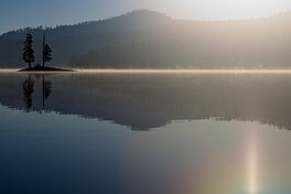
Snag Lake is a lake located in the north eastern part of Lassen Volcanic National Park in California.[2]
Description[]
The large Snag Lake is located to the south of Cinder Cone and the Fantastic Lava Beds at an elevation of 6,050 ft (1,840 m).[1] Water from the nearby Horseshoe Lake empties into Snag Lake via Grassy Creek.[2] Water from Snag Lake continues to flow through the porous lava field that led to the lake's creation eventually making its way into Butte Lake.[3]
Access[]
Snag Lake is accessible by hiking trail only.[2][4]
See also[]
- List of lakes in California
References[]
- ^ a b Google Earth elevation for GNIS coordinates.
- ^ a b c Lassen Volcanic National Park map, 2007.
- ^ Clynne, Michael A.; Champion, Duane E.; Trimble, Deborah A.; Hendley, James W., II; Stauffer, Peter H., How Old is "Cinder Cone"?–Solving a Mystery in Lassen Volcanic Park, California, United States Geological Survey, retrieved 2013-03-28
- ^ "Snag Lake, USGS PROSPECT PEAK (CA) Topo Map". USGS Quad maps. TopoQuest.com. Retrieved 2008-07-05.
This Lassen County, California-related article is a stub. You can help Wikipedia by . |
Categories:
- Lakes of Lassen Volcanic National Park
- Lakes of Lassen County, California
- Lakes of California
- Lakes of Northern California
- Lassen County, California geography stubs