South Coast railway line, Queensland
| South Coast Line | ||
|---|---|---|
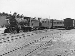 Train at Tweed Heads in 1940 | ||
| Overview | ||
| Owner | Queensland Railways | |
| Service | ||
| Operator(s) | Queensland Railways | |
| History | ||
| Opened | 25 January 1889 (to Southport) 10 August 1903 (to Tweed Heads) | |
| Closed | 1 July 1961 (to Tweed Heads) 30 June 1964 (to Southport) | |
| Technical | ||
| Line length | 73 kilometres | |
| Track gauge | 3 ft 6 in (1,067 mm) | |
| ||
The South Coast railway line (also known as the Tweed railway line) was a railway from Brisbane, the capital city of Queensland, Australia. The route via the South Coast (now known as the Gold Coast) to Tweed Heads on the border of Queensland and New South Wales. The line operated from 1889 to 1964. The Gold Coast railway line re-opened in 1996 along a modified alignment in the north and a new route south but does not extend as far south yet as the South Coast line.
History[]

The Beenleigh railway line opened in 1885[1] before being extended 26 miles (42 km) from Beenleigh railway station to Southport in 1889.[2] The firm of J. W. Sutton and Company of Kangaroo Point in Brisbane provided materials and aided in bridge construction for the railway line.[3]
A branch line running 22 miles (35 km) from Southport Junction (later renamed Ernest Junction) to Tweed Heads opened on 10 August 1903.[4]
It had been hoped that the New South Wales Government would extend its Casino to Murwillumbah line a further 30 kilometres from Murwillumbah to Tweed Heads, but this did not occur due to cost of resuming the land and the expenses associated with the tunnel and bridge that would be required.[5]
Due to the increasing popularity of the motor car, and political interests in road transport, the Tweed Heads branch closed on 1 July 1961, followed by the Beenleigh to Southport line on 30 June 1964.
Stations[]
The initial South Coast line officially opened on 24 January 1889 [6] and included stops at:
| Distance from South Brisbane railway station | Station | Coords | Notes |
|---|---|---|---|
| Yatala | Closed in 1891.[7] | ||
| Stapylton | 27°44′21″S 153°13′48″E / 27.739149°S 153.230014°E | [8] | |
| 31 miles 16 chains (50.2 km) | Ormeau | 27°47′34″S 153°15′55″E / 27.792725°S 153.265299°E | [9][10] |
| 33 miles 79 chains (54.7 km) | Pimpana | 27°48′55″S 153°17′32″E / 27.8152°S 153.2921°E | [10][11] |
| 38 miles 35 chains (61.9 km) | Coomera, | 27°52′22″S 153°18′46″E / 27.872830°S 153.312883°E | [10] |
| 39 miles 27 chains (63.3 km) | 39 Mile Platform (Oxenford) | 27°53′08″S 153°18′55″E / 27.8855°S 153.3154°E | [10][12] |
| 40 miles 56 chains (65.5 km) | Helensvale | 27°53′54″S 153°19′42″E / 27.898255°S 153.328348°E | [10] |
| Coombabah | Closed in 1891.[7] | ||
| 46 miles 40 chains (74.8 km) | Ernest Junction | 27°58′12″S 153°21′32″E / 27.970056°S 153.358775°E | [10] |
| 50 miles 10 chains (80.7 km) | Southport | 27°57′49″S 153°24′40″E / 27.9637°S 153.4110°E | [10][13][14] |

It included a number of cuts, river crossings, long grades and a tunnel [15] at Ernest Junction that remains in situ (and is now heritage-listed).[16] The second branch of the South Coast line, known as the Nerang-Tweed Heads extension,[17] opened 14 September 1903 [18][19] and stretched from Ernest Junction to the Queensland-New South Wales border. Stops included:
| Distance from South Brisbane railway station | Station | Coords | Notes |
|---|---|---|---|
| 47 miles 61 chains (76.9 km) | Molendinar | 27°59′08″S 153°21′22″E / 27.9855°S 153.3560°E | Renamed from Benowa in October 1889.[20][10][21] |
| 49 miles 11 chains (79.1 km) | Nerang | 27°59′43″S 153°20′24″E / 27.9953°S 153.3401°E | [10][22][23] |
| 53 miles 54 chains (86.4 km) | Worongary | [10] | |
| 55 miles 33 chains (89.2 km) | Mudgeeraba | [10] | |
| Reedy Creek | |||
| 61 miles 23 chains (98.6 km) | West Burleigh | 28°06′53″S 153°26′30″E / 28.1147°S 153.4416°E | On the western bank of Tallebudgera Creek roughly where the Pacific Highway crosses the creek today.[10][24] Renamed from Booningba.[25] |
| 62 miles 70 chains (101.2 km) | Elanora | 28°07′28″S 153°27′52″E / 28.1245°S 153.4644°E | At the intersection of Palm Beach Avenue and the Pacific Highway [10][24] |
| 63 miles 79 chains (103.0 km) | Currumbin | 28°08′16″S 153°28′23″E / 28.1378°S 153.4731°E | On the eastern bank of Currumbin Creek. The current pedestrian bridge is the former railway bridge.[10][24][19] |
| 65 miles 46 chains (105.5 km) | Tugun | 28°08′37″S 153°29′40″E / 28.1435°S 153.49434°E | Roughly on the intersection of the Gold Coast Highway and Toolana Street.[10][24] |
| 67 miles 16 chains (108.1 km) | Bilinga | 28°09′36″S 153°30′40″E / 28.1601°S 153.5110°E | Roughly on the intersection of the Gold Coast Highway and George Street.[10][24] |
| 68 miles 4 chains (109.5 km) | Kirra | 28°10′11″S 153°31′34″E / 28.1698°S 153.5262°E | Roughly at the intersection of Coolangatta Road and Haig Street.[10][24] |
| 69 miles 7 chains (111.2 km) | Coolangatta | 28°10′07″S 153°32′12″E / 28.1685°S 153.5367°E | Griffith Street.[10][13][26] |
| 69 miles 33 chains (111.7 km) | Tweed Heads | 28°10′19″S 153°32′26″E / 28.1720°S 153.5405°E | [10] |
Route[]
From Beenleigh, coast-bound trains crossed the Old Pacific Highway three times between there and Yatala. In between these was the impressive Albert River crossing, made of three steel lattice girder spans. After passing Stapylton, the alignment was straight and of good standard, before reaching Ormeau. The alignment began to curve here, eventually reaching the Pimpama River and Pimpama Station. Coomera station was next, and a short distance later, the line crossed the Coomera River on a large bridge, similar to the Albert River bridge but with four spans instead of three. The southern floodplain of the river was crossed on timber trestles, leading to Oxenford. Passing Saltwater Creek, the line went through Helensvale, which had a small halt with little else but a nameboard signalling the station. After climbing nearly two miles, the railway passed through the curved Ernest Junction Tunnel. The station was just past here. The Southport branch continued on to Southport, but the Tweed Heads line continued onwards. Passing the small station of Molendinar, the line passed under the Southport-Nerang Road. The Nerang River bridge was next. Then came Nerang and Mudgeeraba stations, today covered by the busy Pacific Motorway. A tunnel was reached at West Burleigh, before arriving at the station of that name. After crossing Tallebudgera Creek bridge (now also demolished and replaced by the Pacific Motorway) travellers reached Elanora, then came the still extant Currumbin Creek bridge. From here, the route followed today’s Stewart Street between Currumbin and Tugun, the Gold Coast Highway between Tugun and Kirra, Coolangatta Road between Kirra and Coolangatta, and Griffith Street over the border to Tweed Heads.
Note from the editor - I don’t know how to add pictures in, but there are some good ones on https://www.goldcoastmodelrailwayclub.com/history-of-gold-coast-rail.html that I would post if I knew how to put them in this article.
Services[]
Passenger trains ran from South Brisbane to Southport with connecting trains from Ernest Junction or Southport to Tweed Heads. Picnic and excursion trains ran through from South Brisbane to Tweed Heads on Sundays.[27][28][29]
From opening until around 1910, A12 and B13 class locos were the main motive power. From there until the 1950s, services were operated exclusively by PB15 class locomotives, the largest locomotive permitted to cross the Logan River. Diesel rail cars of the 1800 and 2000 classes operated some passenger services from the 1950s until closure in the 1960s.[30][31]
Remains[]

- The Beenleigh railway line is still in use.
- The track bed between Ernest Junction and Southport, and between Tugun and Coolangatta, is still visible.
- The original Nerang station still exist at the Gold Coast Hinterland Heritage Museum at Mudgeeraba.
- The railway bridge over Currumbin Creek was converted to a footbridge. Prior to 1995 the Tallebudgera bridge carried water pipes across the creek. That bridge has since been demolished to make way for widening of the Pacific Motorway.
- Short sections of the route at Currumbin, Coolangatta and Southport have been reused as a pedestrian/bicycle paths.
- The Southport tunnel still exists, but the 2 West Burleigh tunnels do not; they were demolished to make way for the Pacific Motorway.
- The Coolangatta station area is now located between Chalk St and Griffith Street.
Replacement[]
The Gold Coast railway line on a new alignment opened from Beenleigh to Helensvale in 1996, Nerang in 1997, Robina in 1998 and Varsity Lakes in 2009.[32]
See also[]
References[]
- ^ History of Mt Gravatt Our Brisbane
- ^ The Southport Railway Archived 27 April 2020 at the Wayback Machine Brisbane Courier 25 January 1889 page 6
- ^ "Kangaroo Point: Iron Ships and Bridges". The Brisbane Courier. 24 May 1930. p. 22. Retrieved 24 January 2016 – via National Library of Australia.
- ^ Visitors from New South Wales Archived 27 April 2020 at the Wayback Machine The Brisbane Courier 11 August 1903 page 5
- ^ Tweed Heads Railway Extension Archived 24 September 2020 at the Wayback Machine The Brisbane Courier 29 May 1903 page 5
- ^ "THE SOUTHPORT RAILWAY". The Brisbane Courier. XLV (9, 682). 25 January 1889. p. 6. Archived from the original on 27 April 2020. Retrieved 9 May 2016 – via National Library of Australia.
- ^ Jump up to: a b "LOCAL AND GENERAL". Logan Witness. XIII (672). Queensland, Australia. 7 February 1891. p. 2 – via National Library of Australia.
- ^ Beenleigh, Queensland (Map) (2nd ed.). Royal Australian Survey Corps. 1947. Retrieved 29 October 2020.
- ^ "Town of Ormeau" (Map). Queensland Government. 1971. Archived from the original on 5 April 2020. Retrieved 6 April 2020.
- ^ Jump up to: a b c d e f g h i j k l m n o p q r s "Untitled" (Map). Queensland Government. 1947. Archived from the original on 5 April 2020. Retrieved 6 April 2020.
- ^ Tamborine Queensland (Map) (Second ed.). Royal Australian Survey Corps. 1954. Retrieved 30 October 2020.
"Tamborine" (Map). Queensland Government. 1954. Archived from the original on 2 April 2020. Retrieved 20 April 2020.) - ^ "Parish of Barrow" (Map). Queensland Government. 1973. Archived from the original on 24 September 2020. Retrieved 19 April 2020.
- ^ Jump up to: a b "South Coast Rail Line". Archived from the original on 15 September 2014. Retrieved 15 September 2014.
- ^ "Southport" (Map). Queensland Government. 1978. Archived from the original on 5 April 2020. Retrieved 6 April 2020.
- ^ "SOUTHPORT RAILWAY". South Coast Bulletin. 8 (430). Queensland, Australia. 21 August 1936. p. 6. Archived from the original on 24 September 2020. Retrieved 9 May 2016 – via National Library of Australia.
- ^ "Ernest Junction Railway Tunnel (entry 650228)". Queensland Heritage Register. Queensland Heritage Council. Retrieved 25 April 2021.
- ^ "OPENING OF NERANG RAILWAY". Queensland Times, Ipswich Herald And General Advertiser. XLIV (6642). 27 August 1903. p. 2. Retrieved 9 May 2016 – via National Library of Australia.
- ^ "VISITORS FROM NEW SOUTH WALES". The Brisbane Courier. LX (14, 220). 11 August 1903. p. 5. Archived from the original on 27 April 2020. Retrieved 9 May 2016 – via National Library of Australia.
- ^ Jump up to: a b "Currumbin Creek Railway Bridge (former)" (PDF). Gold Coast City Council. Archived (PDF) from the original on 24 September 2020. Retrieved 24 September 2020.
- ^ "Railway Station Names". The Telegraph (Brisbane) (5, 295). Queensland, Australia. 2 October 1889. p. 4. Retrieved 11 October 2020 – via National Library of Australia.
- ^ "Tambourine" (Map). Queensland Government. 1926. Archived from the original on 5 April 2020. Retrieved 5 April 2020.
- ^ "OPENING OF NERANG RAILWAY". Queensland Times, Ipswich Herald and General Advertiser. XLIV (6642). 27 August 1903. p. 2. Retrieved 9 May 2016 – via National Library of Australia.
- ^ "Town of Nerang" (Map). Queensland Government. Archived from the original on 5 April 2020. Retrieved 5 April 2020.
- ^ Jump up to: a b c d e f "Moreton 40 Chain map AG2 series sheet 16 south". Queensland Government. 1929. Archived from the original on 24 September 2020. Retrieved 24 September 2020.
- ^ "Burleigh and Beenleigh". The Brisbane Courier (17, 747). Queensland, Australia. 1 December 1914. p. 6. Retrieved 30 October 2020 – via National Library of Australia.
- ^ "Tweed Heads" (Map). Queensland Government. 1943. Archived from the original on 5 April 2020. Retrieved 6 April 2020.
- ^ "Southport Timetable". The Week. XXVII (682). Brisbane. 12 January 1889. p. 26. Archived from the original on 24 September 2020. Retrieved 18 January 2018 – via National Library of Australia.
- ^ NINE SPECIAL TRAINS BOOKED FOR 4BH PICNIC TO SOUTHPORT (1939, October 21). The Telegraph (Brisbane), p. 4 (LATE WEEK END FINAL ALL THE NEWS). Retrieved January 18, 2018, from http://nla.gov.au/nla.news-article188037010
- ^ "Tweed Heads-Brisbane Railway". Northern Star. 28. New South Wales, Australia. 24 October 1903. p. 8. Archived from the original on 28 September 2020. Retrieved 18 January 2018 – via National Library of Australia.
- ^ "LOCOMOTIVES". The Telegraph (16, 575) (5 O'CLOCK CITY ed.). Brisbane. 15 January 1926. p. 12. Archived from the original on 24 September 2020. Retrieved 18 January 2018 – via National Library of Australia.
- ^ "1st Diesel run". The Courier-Mail (4980). Brisbane. 13 November 1952. p. 3. Retrieved 18 January 2018 – via National Library of Australia.
- ^ Robina-Varsity Lakes rail extension state's most expensive The Courier-Mail 14 December 2009
Bibliography[]
- Alan Arundell (2011). The South Coast Railway: A history of Growth and Transport on the Gold Coast. Water Street Productions. ISBN 0646555286.
- John Kerr and John Armstrong (1978). Destination Sth Brisbane : an illustrated history of the southside railways of Brisbane. Australian Railway Historical Society.
External links[]
| Wikimedia Commons has media related to South Coast railway line, Queensland. |
- Closed railway lines in Queensland
- History of Gold Coast, Queensland
- Public transport in Queensland
- Railway lines opened in 1889
- Railway lines opened in 1903
- Railway lines closed in 1961
- Railway lines closed in 1964
- 3 ft 6 in gauge railways in Australia