Spanish West Florida

| Province of West Florida | |||||||||
|---|---|---|---|---|---|---|---|---|---|
| Province of Viceroyalty of New Spain | |||||||||
| 1783–1821 | |||||||||
 | |||||||||
 | |||||||||
| Capital | Pensacola | ||||||||
| History | |||||||||
| Government | |||||||||
| • Type | Colonial government | ||||||||
| Governor | |||||||||
• 1783-1792 | Arturo O'Neill de Tyrone | ||||||||
• 1819-1821 | José María Callava | ||||||||
| History | |||||||||
| 10 February 1783 | |||||||||
• Disestablished | 1821 | ||||||||
| |||||||||
Spanish West Florida (Spanish: Florida Occidental) was a province of the Spanish Empire from 1783 until 1821, when both it and East Florida were ceded to the United States.
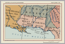
The region of West Florida initially had the same borders as the erstwhile British colony. Much of its territory was gradually annexed by the United States in the West Florida controversy. At its greatest extent, the colony included what are now the Florida Parishes of Louisiana, the southernmost parts of Mississippi and Alabama, and the panhandle of Florida. Whereas southeastern Louisiana and present-day coastal Mississippi and Alabama were annexed either prior to or during the War of 1812, the land which makes up present-day Florida was not acquired until several years later. It became the Florida Territory of the United States in 1822.
History[]


Spain was the first European state to colonize the Florida peninsula, expanding northward from Cuba and establishing long-lasting settlements at St. Augustine, on the Atlantic coast, and at Pensacola and San Marcos (St. Marks), on the Gulf of Mexico coast.[3]
Following Spain's losses to Great Britain during the Seven Years' War, Spain ceded its Florida territory to Britain in 1763. British administrators then divided the territory into two colonies: East Florida, including the Florida peninsula with the capital at St. Augustine, and West Florida, to which was appended part of the territory received from France under the 1763 peace treaty. West Florida extended from the Apalachicola River to the Mississippi River, with its capital at Pensacola.[4]
In 1779, Spain entered the American Revolutionary War on the side of France but not the Thirteen Colonies.[5] Bernardo de Gálvez, governor of Spanish Louisiana, led a military campaign along the Gulf coast, capturing Baton Rouge and Natchez from the British in 1779, Mobile in 1780, and Pensacola in 1781.
In the 1783 peace treaty, Great Britain returned both Florida colonies to Spanish control. Instead of administering Florida as a single province, as it had prior to 1763, New Spain preserved the British arrangement of dividing the territory between East and West Florida (Florida Oriental and Florida Occidental).[6] When Spain acquired West Florida in 1783, the eastern British boundary was the Apalachicola River, but Spain in 1785 moved it eastward to the Suwannee River.[7][8] The purpose was to transfer San Marcos and the district of Apalachee from East Florida to West Florida.[9][10]
See also[]
- Spanish Florida
- New Spain
- British West Florida
- East Florida
- West Florida
- Republic of West Florida
- West Florida Controversy
- Florida Territory
References[]
- ^ Chambers, Henry E. (May 1898). West Florida and its relation to the historical cartography of the United States. Baltimore, Maryland: The Johns Hopkins Press.
- ^ Cox, Isaac Joslin (1918). The West Florida Controversy, 1798-1813 – a Study in American Diplomacy. Baltimore, Maryland: The Johns Hopkins Press.
isaac cox west florida.
- ^ Hernández, Roger E. (1 September 2008). New Spain: 1600-1760s. Marshall Cavendish. p. 37. ISBN 978-0-7614-2936-4.
- ^ Pitot, James (1761–1831) (1979). Observations on the Colony of Louisiana, from 1796 to 1802. Baton Rouge, Louisiana, U.S.: Louisiana State University Press. p. 147. ISBN 978-0-8071-0579-5.
- ^ Tucker, Spencer; Arnold, James R.; Wiener, Roberta, eds. (30 September 2011). The Encyclopedia of North American Indian Wars, 1607–1890: A Political, Social, and Military History. ABC-CLIO. p. 751. ISBN 978-1-85109-697-8.
- ^ James G. Cusick (1 April 2007). The Other War of 1812: The Patriot War and the American Invasion of Spanish East Florida. University of Georgia Press. p. 144. ISBN 978-0-8203-2921-5.
- ^ Wright, J. Leitch (1972). "Research Opportunities in the Spanish Borderlands: West Florida, 1781-1821". Latin American Research Review. Latin American Studies Association. 7 (2): 24–34. JSTOR 2502623. Wright also notes, "It was some time after 1785 before it was clearly established that Suwannee was the new eastern boundary of the province of Apalachee."
- ^ Weber, David J. (1992). The Spanish Frontier in North America. New Haven, Connecticut, USA: Yale University Press. p. 275. ISBN 0300059175.
Spain never drew a clear line to separate the two Floridas, but West Florida extended easterly to include Apalachee Bay, which Spain shifted from the jurisdiction of St. Augustine to more accessible Pensacola.
- ^ "The Evolution of a State, Map of Florida Counties - 1820". 10th Circuit Court of Florida. Retrieved 2016-01-26.
Under Spanish rule, Florida was divided by the natural separation of the Suwanee River into West Florida and East Florida.
- ^ Klein, Hank. "History Mystery: Was Destin Once in Walton County?". The Destin Log. Retrieved 2016-01-26.
On July 21, 1821 all of what had been West Florida was named Escambia County, after the Escambia River. It stretched from the Perdido River to the Suwanee River with its county seat at Pensacola.
Bibliography[]
- Arthur, Stanley Clisby (1935). The Story of the West Florida Rebellion. St. Francisville Democrat. ISBN 1-885480-47-4. OCLC 1354769. Reprint, Pioneer Publishing, 164 pp.
- Cox, Isaac Joslin (1918). The West Florida Controversy, 1798 - 1813: A Study in American Diplomacy. Baltimore, Md: The Johns Hopkins Press. OCLC 479174.
- Gannon, Michael (1996). The New History of Florida. University Press of Florida. ISBN 0-8130-1415-8.
- McMichael, Andrew (2008). Atlantic Loyalties: Americans in Spanish West Florida, 1785–1810. University of George Press. ISBN 978-0-8203-3004-4.
- West Florida Collection, Center for Southeast Louisiana Studies, Linus A. Sims Memorial Library, Southeastern Louisiana University, Hammond. For a summary of the holdings see West Florida Archival Collection
| |
| |
| |
| |
| |
|
- States and territories established in 1783
- States and territories disestablished in 1821
- Spanish Florida
- West Florida
- History of Alabama
- History of Florida
- History of Louisiana
- History of Mississippi