East Florida
| East Florida | |||||||||
|---|---|---|---|---|---|---|---|---|---|
| Territory of Great Britain (1763–1783), Spain (1783–1821), United States (1821–22) | |||||||||
| 1763–1822 | |||||||||
  Left: Red Ensign of Great Britain Right: Flag of the Spanish Empire | |||||||||
| Capital | St. Augustine | ||||||||
| Government | |||||||||
| Governor | |||||||||
• 1763–1784 | 5 under Britain | ||||||||
• 1784–1821 | 8 under Spain | ||||||||
• 1821 | 1 U.S. military commissioner | ||||||||
| History | |||||||||
• Treaty of Paris | 10 February, 1763 | ||||||||
| 25 November 1783 | |||||||||
| 1821 | |||||||||
• Merged into Florida Territory | 30 March, 1822 | ||||||||
| |||||||||
East Florida (Spanish: Florida Oriental) was a colony of Great Britain from 1763 to 1783 and a province of Spanish Florida from 1783 to 1821. Great Britain gained control of the long-established Spanish colony of La Florida in 1763 as part of the treaty ending the French and Indian War (as the Seven Years' War was called in North America). Deciding that the territory was too large to administer as a single unit, Britain divided Florida into two colonies separated by the Apalachicola River: East Florida with its capital in St. Augustine and West Florida with its capital in Pensacola. East Florida was much larger and comprised the bulk of the former Spanish territory of Florida and most of the current state of Florida. However, most of the Spanish population, including all of St Augustine emigrated after the treaty.[1]
The sparsely populated Florida colonies remained loyal to Great Britain during the American Revolutionary War. However, as part of the 1783 treaty in which Britain officially recognized the independence of its former American colonies, it also ceded both Floridas back to Spain, which maintained them as separate colonies while moving the boundary east to the Suwannee River.
By the early 1800s, Spain had proved uninterested in and incapable of organizing or defending either of the two Floridas much beyond the two small capital cities. American settlers moved into the territory without authorization, causing conflict with the Seminoles, a new Native American culture which had coalesced from refugees of nearby southern states. British operatives fomented turmoil in Florida during the War of 1812 and prompted the involvement of American troops, all in Spanish territory. American settlers in East Florida further weakened Spanish control in 1812 when a group calling themselves the Patriots declared the short-lived Republic of East Florida at Amelia Island with semi-official support from the U.S. government.
Border disputes between the Americans and Seminoles in Florida continued after the war. By 1817, much of Spanish West Florida had been occupied and annexed by the United States over Spanish objections, with the land eventually becoming portions of the states of Louisiana, Alabama, and Mississippi. After a decade of intensifying border disputes and American incursions, Spain ceded both Floridas to the U.S. in the Adams–Onís Treaty of 1819. The U.S. officially took possession in 1821, and in 1822, all of East Florida and the remaining portions of West Florida were combined into a single Florida Territory with borders that closely approximated those of the current state of Florida.
British period[]
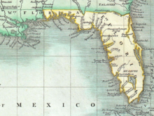
Under the terms of the 1763 Treaty of Paris, which ended the Seven Years' War (the French and Indian War), Spain ceded Spanish Florida to Britain. At the same time, Britain received all of French Louisiana east of the Mississippi River, with the exception of New Orleans, from France. Determining the new territory too large to administer as one unit, Britain divided its new southeastern acquisitions into two new colonies separated by the Apalachicola River: East Florida, with its capital in the old Spanish city of St. Augustine, and West Florida, with its capital at Pensacola. However, most of the Spanish population departed following the signing of the treaty, with the entirety of St Augustine emigrating to Cuba.[1]
The settlement of East Florida was heavily linked in London with the same interests that controlled Nova Scotia. The East Florida Society of London and the Nova Scotia Society of London had many overlapping members, and Council frequently followed their suggestions on the granting of lands to powerful merchant interests in London.
Perhaps it is strange to think of such dissimilar geographic areas with such opposing climates as having much in common. But if one considers naval and military strategy, one can see that these areas have a common significance, especially when viewed from London by the ministry. Halifax (Nova Scotia) was the command post for both the admiral and general in charge of the American forces.... St. Augustine evoked the same strategic considerations. These posts have been described as the two centers of strength to which the British army was withdrawn in the late 1760s.[2]
The apportionment of lands in the new colonies fell to the same group of English and Scottish entrepreneurs and merchant interests, led chiefly by the Englishman Richard Oswald, later a diplomat, and the British general James Grant, who would later become governor of East Florida. A list of the grantees in both Florida and Canada show that the plums fell to a well-connected—and inter-connected—group. Lincoln's Inn barrister Levett Blackborne, grandson of Sir Richard Levett, a powerful merchant and Lord Mayor of London, came in for grants of 20,000 acres (81 km2) in both locales, for instance. Other aristocrats, nobles and merchants did the same.
The most powerful lubricant between the East Florida speculators and the Nova Scotia speculators was Col. Thomas Thoroton of Flintham, Nottinghamshire. Thoroton, the stepbrother of Levett Blackborne, had married an illegitimate daughter of the Duke of Rutland and often lived at Belvoir Castle, where he acted as principal agent to the Duke, who, along with his son the Marquis of Granby, were heavily involved in overseas ventures. Thoroton frequently acted as the go-between for Richard Oswald and James Grant, particularly after those two gave up their Nova Scotia Grants to focus on East Florida, where a drumbeat of steady speculation (particularly from Dr. Andrew Turnbull and Dr. William Stork) had fanned the flames of interest in London.[2] It was not until March 1781 that the Governor of East Florida, Patrick Tonyn, called elections for a provincial legislature.[3]
Both Floridas remained loyal to Great Britain during the American War of Independence. Spain participated indirectly in the war as an ally of France and captured Pensacola from the British in 1781. In the 1783 Treaty of Paris, which ended the war, the British ceded both Floridas to Spain. The same treaty recognized the independence of the United States, directly to the north.
Spanish period: Florida Oriental[]

Under Spanish rule, the provinces of East Florida and West Florida initially remained divided by the Apalachicola River, the boundary established by the British.[4][5][6] But Spain in 1785 moved it eastward to the Suwanee River.[7][8][9]

Spain continued to administer East and West Florida as separate provinces. The Spanish offered favorable terms for acquiring land, which attracted many settlers from the newly formed United States. There were several territorial disputes between the US and Spain, some resulting in military action.[citation needed]
An American army under Andrew Jackson invaded East Florida during the First Seminole War. Jackson's forces captured San Marcos on 7 April 1818; as well as Fort Barrancas at West Florida's capital, Pensacola, on 24 May 1818.
James Monroe's Secretary of State, John Quincy Adams, defined the American position on this issue. Adams accused Spain of breaking Pinckney's Treaty by failing to control the Seminoles. Faced with the prospect of losing control, Spain formally ceded all of its Florida territory to the US under the Adams–Onís Treaty in 1819 (ratified in 1821), in exchange for the US ceding its claims on Texas and the US paying any claims its citizens might have against Spain, up to $5,000,000.
In 1822, the US Congress organized the Florida Territory. In 1845, Florida was admitted as the 27th state of the United States.
Governors[]
List of governors of East Florida[]
| Name | Term | Notes |
|---|---|---|
| John Hedges | 20 Jul 1763 – 30 Jul 1763 | capital at St. Augustine (acting governor) |
| Francis Ogilvie | 30 Jul 1763 – 29 Aug 1764 | acting governor |
| James Grant | 29 Aug 1764 – 9 May 1771 | Considered the inaugural governor. |
| John Moultrie | 9 May 1771 – 1 Mar 1774 | |
| Patrick Tonyn | 1 Mar 1774 – 12 Jul 1784 | |
| Vicente Manuel de Céspedes y Velasco | 12 July 1784 – July 1790 | capital at St. Augustine |
| Juan Nepomuceno de Quesada y Barnuevo | July 1790 – March 1796 | |
| Bartolomé Morales | March 1796 – June 1796 | acting governor |
| Enrique White | June 1796 – March 1811 | |
| Juan José de Estrada | March 1811 – June 1812 | Patriot War with U.S. |
| Sebastián Kindelán y Oregón | June 1812 – June 1815 | Patriot War with U.S. |
| Juan José de Estrada | June 1815 – January 1816 | |
| José María Coppinger | January 1816 – 10 July 1821 | First Seminole War with U.S. |
See also[]
- The Republic of East Florida
- George Mathews (Georgia), Patriot War of East Florida (1812)
- Seminole Wars
- Mosquito County, Florida
- West Florida
- History of Florida
- Spanish colonization of the Americas
- Spanish Florida
References[]
- ^ Jump up to: a b "The British Period (1763-1784) - Fort Matanzas National Monument". U.S. National Park Service. Retrieved 5 January 2021.
- ^ Jump up to: a b The East Florida Society of London, Florida Historical Quarterly, Vol. LIV, No. 4, April 1976 Archived 14 January 2009 at the Wayback Machine
- ^ The Impact of Loyalists in British East Florida, page 7
- ^ Bernard Romans (15 November 1999) [1775]. A Concise Natural History of East and West Florida. University of Alabama Press. p. 43. ISBN 978-0-8173-0876-6.
- ^ James Grant Forbes (1821). Sketches, Historical and Topographical, of the Floridas: More Particularly of East Florida. C.S. Van Winkle. p. 120.
- ^ A Journal of the Proceedings of the Senate of the Territory of Florida at its Second Session. publisher not identified. 1840. p. 81.
- ^ Wright, J. Leitch (1972). "Research Opportunities in the Spanish Borderlands: West Florida, 1781-1821". Latin American Research Review. Latin American Studies Association. 7 (2): 24–34. JSTOR 2502623.
When Spain acquired West Florida in 1783, the eastern British boundary was the Apalachicola River, but Spain in 1785 moved it eastward to the Suwanee River.[at Footnote 1:"It was some time after 1785 before it was clearly established that Suwannee was the new eastern boundary of the province of Apalachee."] (Few maps indicate this eastward shift.) The purpose was to transfer San Marcos and the district of Apalachee from East Florida to West Florida.
- ^ Weber, David J. (1992). The Spanish Frontier in North America. New Haven, Connecticut: Yale University Press. p. 275. ISBN 978-0-300-05917-5.
Spain never drew a clear line to separate the two Floridas, but West Florida extended easterly to include Apalachee Bay, which Spain shifted from the jurisdiction of St. Augustine to more accessible Pensacola.
- ^ "Territory of Florida Map 1". Historical Florida County Maps. University of Florida. 1936. Archived from the original on 3 February 2016.
Under Spanish rule, Florida was divided by the natural separation of the Suwanee River into West Florida and East Florida. Upon the purchase of Florida, (1819) by the United States of America, West Florida and East Florida became two counties: Escambia County and St Johns County, so named and so ordained as counties with respective county governments by Andrew Jackson, Military Governor of the Territory of Florida.
External links[]
| show |
|---|

| show |
|---|
- 1763 establishments in the British Empire
- Colonial United States (British)
- Colonial United States (Spanish)
- Former British colonies and protectorates in the Americas
- Former regions and territories of the United States
- Pre-statehood history of Florida
- Spanish colonization of the Americas
- States and territories disestablished in 1822
- British Florida