St. Marks River
| St. Marks River | |
|---|---|
 St. Marks River viewed from U.S. Highway 98. | |
 St. Marks River watershed | |
| Location | |
| Country | United States |
| State | Florida |
| Counties | Leon, Jefferson, Wakulla |
| District | NWFWMD |
| Physical characteristics | |
| Source | Tallahassee Hills |
| • location | Capitola, Florida |
| • coordinates | 30°28′40″N 84°06′01″W / 30.47778°N 84.10028°W |
| Mouth | Apalachee Bay |
• location | Port Leon, Florida |
• coordinates | 30°4′53″N 84°11′31″W / 30.08139°N 84.19194°WCoordinates: 30°4′53″N 84°11′31″W / 30.08139°N 84.19194°W |
| Length | 36 mi (58 km) |
| Basin size | 1,150 sq mi (3,000 km2) |
| Discharge | |
| • average | 1,122 cu ft/s (31.8 m3/s) |
| Discharge | |
| • location | St. Marks River Rise |
| • average | 433 cu ft/s (12.3 m3/s) |
| Basin features | |
| Tributaries | |
| • left | East River |
| • right | Lafayette Creek, Wakulla River |

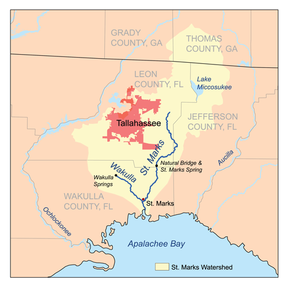
The St. Marks River is a river in the Big Bend region of Florida. It has been classified by the Florida Department of Environmental Protection as an Outstanding Florida Water, and is the easternmost river within the Northwest Florida Water Management District.[1]
The St. Marks River begins in eastern Leon County, Florida and flows 36 miles (58 km) through Leon and Wakulla counties into Apalachee Bay, an arm of the Gulf of Mexico. It has a drainage basin of 1,150 square miles (3,000 km2)[1] in size. It has one significant tributary, the Wakulla River.
A few miles south of its source the St. Marks passes under a natural bridge at Natural Bridge Battlefield Historic State Park and then disappears underground to become a subterranean river for about one-half mile. The river emerges at the , a first magnitude spring with a discharge of 433cf/s,[1] to pass over a stretch of rocks, forming rapids.
The incorporated town of St. Marks is located at the juncture of the Wakulla and St. Marks Rivers. To the north is the community of Newport. Between St. Marks and Newport is a small industrial area serviced by barge.
The San Marcos de Apalache Historic State Park and St. Marks lighthouse are located near the mouth of the river, while the 's is located on the river in St. Marks.
List of crossings[]
This list is incomplete; you can help by . (August 2008) |
References[]
- Marth, Marty. 1990. St. Marks River. in Marth, Del and Marty Marth, eds. The Rivers of Florida. Sarasota, Florida: Pineapple Press, Inc. ISBN 0-910923-70-1.
- protectingourwater.org: St. Marks River Watershed
- Emerging Waters: Springs of Northwest Florida
- St. Marks River & Apalachee Bay Watershed
- City Of Tallahassee Sam O. Purdom Generating Station
- Bodies of water of Jefferson County, Florida
- Bodies of water of Leon County, Florida
- Rivers of Florida
- Rivers of Wakulla County, Florida
- Outstanding Florida Waters
- Subterranean rivers of the United States
- Big Bend Region, Florida geography stubs
- Leon County, Florida geography stubs
- Florida river stubs