State Highway 63 (New Zealand)
This article needs additional citations for verification. (March 2016) |
 | ||||
|---|---|---|---|---|
 | ||||
| Route information | ||||
| Maintained by NZ Transport Agency | ||||
| Length | 117 km (73 mi) | |||
| Major junctions | ||||
| Northeast end | ||||
| Southwest end | ||||
| Location | ||||
| Primary destinations | , Tophouse, Saint Arnaud, Lake Rotoiti | |||
| Highway system | ||||
| ||||
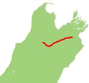
State Highway 63 (SH 63) is a state highway located in the northern parts of the South Island of New Zealand. It is 117 km long and runs between the settlements of Renwick (in Marlborough) and Kawatiri Junction (in the Tasman region) via Saint Arnaud, providing a bypass of the city of Nelson. Despite being a convenient link between the West Coast and Marlborough, and being a relatively straight highway along most of its length, it is only classified by the NZTA as a secondary collector highway.[1]
Route[]
SH 63 begins just to the east of Renwick at SH 6, and parallels the course of the Wairau River for 93 kilometres, originally to the south of the river before crossing to the north side about 20 km from the Marlborough/Tasman border, while passing through the settlements of Wairau Valley, Hillersden and Tophouse. Just before reaching Tophouse, the Wairau River veers to south while the road arrives in St. Arnaud at the shores of Lake Rotoiti. After St. Arnaud the road swings to the northwest and follows the last 24 km alongside the Buller River. At Kawatiri Junction, it terminates at SH 6 between Murchison and the Hope Saddle.[2]
Major intersections[]
This article contains a bulleted list or table of intersections which should be presented in a properly formatted junction table. (November 2021) |
| Territorial authority | Location | km | jct | Destinations | Notes |
|---|---|---|---|---|---|
| Marlborough District | Renwick | 0 | SH 63 begins | ||
| 68.4 | Wairau River | ||||
| Tasman District | Tophouse | 88 | Korere-Tophouse Road | Alternative route to Nelson | |
| 96.3 | Buller River | ||||
| Kawatiri | 117 | SH 63 ends |
See also[]
References[]
- ^ "One Network Road Classification" (PDF). New Zealand Transport Agency. Retrieved 10 November 2018.
- ^ State Highway 63 on Google Maps
External links[]
| National | ||
|---|---|---|
| North Island |
| |
| South Island | ||
| Former state highways | ||
| Touring routes | ||
This New Zealand road or road transport-related article is a stub. You can help Wikipedia by . |
- State Highways in New Zealand
- Transport in the Marlborough Region
- New Zealand road stubs