State Road, Delaware
State Road, Delaware | |
|---|---|
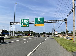 Split between US 13 and US 40 in State Road | |
 State Road | |
| Coordinates: 39°39′2″N 75°37′22″W / 39.65056°N 75.62278°WCoordinates: 39°39′2″N 75°37′22″W / 39.65056°N 75.62278°W | |
| Country | United States |
| State | Delaware |
| County | New Castle |
| Elevation | 36 ft (11 m) |
| Time zone | UTC-5 (Eastern (EST)) |
| • Summer (DST) | UTC-4 (EDT) |
| Area code(s) | 302 |
| GNIS feature ID | 214690[1] |


State Road is an unincorporated community in New Castle County, Delaware, United States. State Road is located at the intersection of U.S. Route 13 and U.S. Route 40 southwest of New Castle.[2]
For many years, it was the location of a major rest stop on the intercity bus network,[3] which billed itself as "the Place Where The Nation Meets and Eats".[4] It had opened in 1951 and closed in 1992, as Greyhound began moving its operations to its Wilmington agency.[5] The area earlier had a stop on the New York, Philadelphia and Norfolk Railroad.[6]
References[]
- ^ "State Road". Geographic Names Information System. United States Geological Survey.
- ^ Delaware Department of Transportation (2008). Delaware Official Transportation Map (PDF) (Map). Dover: Delaware Department of Transportation.
- ^ Russel's Official National Motor Coach Guide. Cedar Rapids, IA: Russell's Guides, Inc. 1991.
- ^ Axthelm, Pete (3 March 1969). "Tracking the Action to Bowie". New York Magazine. Retrieved 8 May 2013.
- ^ Dallabrida, Dale (November 8, 1992). "End of the Road. Clemente's bus line rolls to a stop". Business. News-Journal (Wilmington, Delaware). Retrieved July 7, 2021.
- ^ "Map of the Philadelphia, Wilmington and Baltimore Railroad Systems". Alan, Lans & Scott. Retrieved 4 Mar 2018.
External links[]
 Media related to State Road, Delaware at Wikimedia Commons

This Delaware state location article is a stub. You can help Wikipedia by . |
Categories:
- Unincorporated communities in New Castle County, Delaware
- Unincorporated communities in Delaware
- Delaware geography stubs