Stavanger/Sandnes
Stavanger/Sandnes | |
|---|---|
Urban area | |
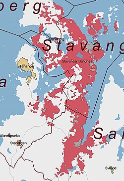 The red areas are included in Stavanger/Sandnes | |
| Coordinates: 58°57′54″N 05°43′04″E / 58.96500°N 5.71778°ECoordinates: 58°57′54″N 05°43′04″E / 58.96500°N 5.71778°E | |
| Country | Norway |
| Region | Western Norway |
| County | Rogaland |
| District | Jæren |
| Area | |
| • Total | 73.2 km2 (28.3 sq mi) |
| Population (2015)[1] | |
| • Total | 210,874 |
| • Density | 2,881/km2 (7,460/sq mi) |
| Time zone | UTC+01:00 (CET) |
| • Summer (DST) | UTC+02:00 (CEST) |

Stavanger/Sandnes is the third largest urban area in Norway. It consists of the densely built-up areas in the municipalities of Stavanger, Sandnes, Sola, and Randaberg, most of which are located on the Stavanger Peninsula, its surrounding islands, and the mainland south of the peninsula. Stavanger/Sandnes is the central part of the Stavanger Region.
On 1 January 2015, the 73.2-square-kilometre (28.3 sq mi) urban area had a population of 210,874. This gives the urban area a population density of 2,881 inhabitants per square kilometre (7,460/sq mi).[1] The area has had a big growth in population, and is one of the fastest growing urban areas in Norway. It is expected that larger portions of Sola municipality will grow together with the urban area in the future.
Population[]
| Name | Population in this urban area | Total municipal population |
|---|---|---|
| Stavanger | 129,300 | 132,102 |
| Sandnes | 58,694 | 73,624 |
| Sola | 13,846 | 25,708 |
| Randaberg | 9,034 | 10,556 |
References[]
- ^ a b c d Statistisk sentralbyrå (1 January 2015). "Urban settlements. Population and area, by municipality".
As of 1 January 2019, according to Statistics Norway [1] | ||||||||
|  | |||||||
- Stavanger
- Sandnes