Stephens, Arkansas
This article may be in need of reorganization to comply with Wikipedia's layout guidelines. (June 2015) |
Stephens, Arkansas | |
|---|---|
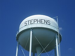
 Water tower in Stephens | |
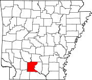
 Location of Stephens in Ouachita County, Arkansas. | |
| Coordinates: 33°24′54″N 93°4′6″W / 33.41500°N 93.06833°WCoordinates: 33°24′54″N 93°4′6″W / 33.41500°N 93.06833°W | |
| Country | United States |
| State | Arkansas |
| County | Ouachita |
| Area | |
| • Total | 2.77 sq mi (7.17 km2) |
| • Land | 2.76 sq mi (7.14 km2) |
| • Water | 0.01 sq mi (0.03 km2) |
| Elevation | 249 ft (76 m) |
| Population (2010) | |
| • Total | 891 |
| • Estimate (2019)[1] | 787 |
| • Density | 285.56/sq mi (110.27/km2) |
| Time zone | UTC-6 (Central (CST)) |
| • Summer (DST) | UTC-5 (CDT) |
| ZIP code | 71764 |
| Area code(s) | 870 |
| FIPS code | 05-66860 |
| GNIS feature ID | 0055203 |


Stephens is a city in Ouachita County, Arkansas, United States. The population was 891 at the 2010 census. It is part of the Camden Micropolitan Statistical Area. Stephens was incorporated in 1889.
Geography[]
Stephens is located at 33°24′54″N 93°4′6″W / 33.41500°N 93.06833°W (33.415025, -93.068311).[3]
According to the United States Census Bureau, the city has a total area of 2.8 square miles (7.3 km2), of which 2.7 square miles (7.0 km2) is land and 0.04 square miles (0.10 km2) (0.73%) is water.
Demographics[]
| Historical population | |||
|---|---|---|---|
| Census | Pop. | %± | |
| 1890 | 379 | — | |
| 1900 | 407 | 7.4% | |
| 1910 | 572 | 40.5% | |
| 1920 | 769 | 34.4% | |
| 1930 | 1,045 | 35.9% | |
| 1940 | 998 | −4.5% | |
| 1950 | 1,283 | 28.6% | |
| 1960 | 1,275 | −0.6% | |
| 1970 | 1,184 | −7.1% | |
| 1980 | 1,366 | 15.4% | |
| 1990 | 1,137 | −16.8% | |
| 2000 | 1,152 | 1.3% | |
| 2010 | 891 | −22.7% | |
| 2019 (est.) | 787 | [1] | −11.7% |
| U.S. Decennial Census[4] | |||
As of the 2010 United States Census, there were 891 people living in the city. The racial makeup of the city was 57.1% Black, 40.6% White, 0.1% Native American, 0.1% from some other race and 1.1% from two or more races. 0.9% were Hispanic or Latino of any race.
As of the census[5] of 2000, there were 1,152 people, 448 households, and 317 families living in the city. The population density was 421.8 people per square mile (162.9/km2). There were 509 housing units at an average density of 186.4/sq mi (72.0/km2). The racial makeup of the city was 53.04% White, 45.83% Black or African American, 0.35% Native American, 0.17% from other races, and 0.61% from two or more races. 0.69% of the population were Hispanic or Latino of any race.
There were 448 households, out of which 30.6% had children under the age of 18 living with them, 47.8% were married couples living together, 19.9% had a female householder with no husband present, and 29.2% were non-families. 28.1% of all households were made up of individuals, and 19.4% had someone living alone who was 65 years of age or older. The average household size was 2.57 and the average family size was 3.14.
In the city, the population was spread out, with 28.3% under the age of 18, 8.5% from 18 to 24, 23.5% from 25 to 44, 22.0% from 45 to 64, and 17.7% who were 65 years of age or older. The median age was 37 years. For every 100 females, there were 79.2 males. For every 100 females age 18 and over, there were 74.3 males.
The median income for a household in the city was $22,045, and the median income for a family was $30,903. Males had a median income of $25,568 versus $20,333 for females. The per capita income for the city was $10,608. About 30.4% of families and 32.6% of the population were below the poverty line, including 41.7% of those under age 18 and 28.8% of those age 65 or over.
Education[]
Students are zoned to the Camden Fairview School District, including Camden Fairview High School.
It was previously served by the Stephens School District, which operated Stephens High School. The Arkansas Board of Education voted to dissolve the Stephens district in April 2014. A portion in Ouachita County was assigned to Camden Fairview, affecting about 140 students. Camden Fairview took ownership of the Stephens district buildings in Stephens. According to Mike McNeill of the , the expected outcome was that the Camden Fairview district would give the Stephens school property to the Stephens city government.[6]
Notable people[]
- Dee Brown, author
- Bobby Collier, American football player
- Barbara Hendricks, opera and lieder soprano singer.
- Joe Perry, NFL Hall of Fame running back[7]
- Dick Hughes, baseball player, pitcher for the 1967 St. Louis Cardinals World Series champion team.
- Frank Spooner, Louisiana businessman and politician, born in Stephens in 1937.[8]
References[]
- ^ Jump up to: a b "Population and Housing Unit Estimates". United States Census Bureau. May 24, 2020. Retrieved May 27, 2020.
- ^ "2019 U.S. Gazetteer Files". United States Census Bureau. Retrieved June 30, 2020.
- ^ "US Gazetteer files: 2010, 2000, and 1990". United States Census Bureau. 2011-02-12. Retrieved 2011-04-23.
- ^ "Census of Population and Housing". Census.gov. Retrieved June 4, 2015.
- ^ "U.S. Census website". United States Census Bureau. Retrieved 2008-01-31.
- ^ McNeill, Mike (2014-04-11). "5-2 state board vote shuts down Stephens School District". . Retrieved 2018-05-23.
- ^ "Joe Perry". databaseFootball.com. Archived from the original on August 8, 2013. Retrieved November 26, 2012.
- ^ Billy Hathorn, "Otto Passman, Jerry Huckaby, and Frank Spooner: The Louisiana Fifth Congressional District Election of 1976", Louisiana History: The Journal of the Louisiana Historical Association, LIV No. 3 (Summer 2013), p. 346
| Wikimedia Commons has media related to Stephens, Arkansas. |
- Cities in Ouachita County, Arkansas
- Cities in Arkansas
- Camden, Arkansas micropolitan area
- Populated places established in 1889


