Sturt County

From Wikipedia, the free encyclopedia

Map all coordinates using: OpenStreetMap 
Download coordinates as: KML
Sturt
New South Wales
Sturt NSW.PNG
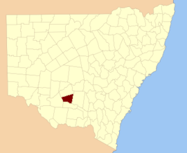
Location in New South Wales
Lands administrative divisions around Sturt:
Nicholson Nicholson Cooper
Waradgery Sturt Cooper
Waradgery Boyd Boyd
The Carathool Bridge over the Murrumbidgee between Sturt and Boyd
Sturt County NSW as shown on John Sands 1886 map)[1]

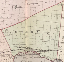
Sturt County is one of the 141 Cadastral divisions of New South Wales. It contains the locality of Carrathool. The Murrumbidgee River is the southern boundary.

Sturt County was named in honour of the explorer, soldier and public servant Charles Sturt (1795-1869).[2]

Parishes within this county[]

A full list of parishes found within this county; their current LGA and mapping coordinates to the approximate centre of each location is as follows:

Parish LGA Coordinates
Carrathool Shire Council 34°18′54″S 145°28′04″E / 34.31500°S 145.46778°E / -34.31500; 145.46778 (Alleyne)
City of Griffith 34°22′54″S 145°55′04″E / 34.38167°S 145.91778°E / -34.38167; 145.91778 (Baillie)
City of Griffith 34°13′54″S 146°00′04″E / 34.23167°S 146.00111°E / -34.23167; 146.00111 (Ballingall)
Hay Shire Council 34°13′54″S 145°11′04″E / 34.23167°S 145.18444°E / -34.23167; 145.18444 (Beabula)
City of Griffith 34°21′54″S 145°47′04″E / 34.36500°S 145.78444°E / -34.36500; 145.78444 (Bendigo)
Carrathool Shire Council 34°28′54″S 145°55′04″E / 34.48167°S 145.91778°E / -34.48167; 145.91778 (Benerembah)
Carrathool Shire Council 34°25′54″S 145°45′04″E / 34.43167°S 145.75111°E / -34.43167; 145.75111 (Bringagee)
Buckley Carrathool Shire Council 34°09′54″S 145°29′04″E / 34.16500°S 145.48444°E / -34.16500; 145.48444 (Buckley)
Carrathool Shire Council 34°23′54″S 145°34′04″E / 34.39833°S 145.56778°E / -34.39833; 145.56778 (Cajaldura)
Carrathool Carrathool Shire Council 34°22′54″S 145°30′04″E / 34.38167°S 145.50111°E / -34.38167; 145.50111 (Carrathool)
Carrathool Shire Council 34°05′54″S 145°28′04″E / 34.09833°S 145.46778°E / -34.09833; 145.46778 (Carrego)
Carrathool Shire Council 34°08′54″S 145°44′04″E / 34.14833°S 145.73444°E / -34.14833; 145.73444 (Cockburn)
Carrathool Shire Council 34°02′54″S 145°51′04″E / 34.04833°S 145.85111°E / -34.04833; 145.85111 (Denny)
City of Griffith 34°23′54″S 145°51′04″E / 34.39833°S 145.85111°E / -34.39833; 145.85111 (Djallah)
Hay Shire Council 34°11′54″S 145°09′04″E / 34.19833°S 145.15111°E / -34.19833; 145.15111 (Downey)
Carrathool Shire Council 34°18′54″S 145°35′04″E / 34.31500°S 145.58444°E / -34.31500; 145.58444 (Ercildoune)
Hervey Carrathool Shire Council 34°10′54″S 145°42′04″E / 34.18167°S 145.70111°E / -34.18167; 145.70111 (Hervey)
Carrathool Shire Council 34°21′54″S 145°23′04″E / 34.36500°S 145.38444°E / -34.36500; 145.38444 (Houlong)
Carrathool Shire Council 34°18′54″S 145°41′04″E / 34.31500°S 145.68444°E / -34.31500; 145.68444 (Hyde Park)
Carrathool Shire Council 34°04′54″S 146°00′04″E / 34.08167°S 146.00111°E / -34.08167; 146.00111 (Kooba)
Carrathool Shire Council 34°23′54″S 145°40′04″E / 34.39833°S 145.66778°E / -34.39833; 145.66778 (Kooroongal)
City of Griffith 34°15′54″S 145°48′04″E / 34.26500°S 145.80111°E / -34.26500; 145.80111 (Learmonth)
Carrathool Shire Council 34°11′54″S 145°26′04″E / 34.19833°S 145.43444°E / -34.19833; 145.43444 (Lethington)
Carrathool Shire Council 34°05′54″S 145°37′04″E / 34.09833°S 145.61778°E / -34.09833; 145.61778 (Livingstone)
Carrathool Shire Council 34°02′54″S 145°43′04″E / 34.04833°S 145.71778°E / -34.04833; 145.71778 (Maiden)
Carrathool Shire Council 34°10′54″S 145°37′04″E / 34.18167°S 145.61778°E / -34.18167; 145.61778 (Mair)
Carrathool Shire Council 34°07′54″S 145°19′04″E / 34.13167°S 145.31778°E / -34.13167; 145.31778 (Mills)
Mirrool City of Griffith 34°08′54″S 146°02′04″E / 34.14833°S 146.03444°E / -34.14833; 146.03444 (Mirrool)
Carrathool Shire Council 34°02′54″S 145°55′04″E / 34.04833°S 145.91778°E / -34.04833; 145.91778 (Munro)
City of Griffith 34°09′54″S 145°49′04″E / 34.16500°S 145.81778°E / -34.16500; 145.81778 (North Bringagee)
Carrathool Shire Council 34°12′54″S 145°19′04″E / 34.21500°S 145.31778°E / -34.21500; 145.31778 (North Uardry)
City of Griffith 33°59′54″S 145°53′04″E / 33.99833°S 145.88444°E / -33.99833; 145.88444 (O'Brien)
Carrathool Shire Council 34°14′54″S 145°36′04″E / 34.24833°S 145.60111°E / -34.24833; 145.60111 (Quambatook)
Tabbita Carrathool Shire Council 33°54′54″S 146°02′04″E / 33.91500°S 146.03444°E / -33.91500; 146.03444 (Tabbita)
Tabbita Carrathool Shire Council 33°56′54″S 145°57′04″E / 33.94833°S 145.95111°E / -33.94833; 145.95111 (Tabbita)
Carrathool Shire Council 34°13′54″S 145°31′04″E / 34.23167°S 145.51778°E / -34.23167; 145.51778 (Terrapee)
Carrathool Shire Council 34°29′54″S 145°14′04″E / 34.49833°S 145.23444°E / -34.49833; 145.23444 (Toms Point)
Carrathool Shire Council 34°20′54″S 145°18′04″E / 34.34833°S 145.30111°E / -34.34833; 145.30111 (Uardry)
Warburn City of Griffith 34°16′54″S 145°53′04″E / 34.28167°S 145.88444°E / -34.28167; 145.88444 (Warburn)
Carrathool Shire Council 34°14′54″S 145°42′04″E / 34.24833°S 145.70111°E / -34.24833; 145.70111 (Wiveon)
Carrathool Shire Council 34°28′54″S 145°50′04″E / 34.48167°S 145.83444°E / -34.48167; 145.83444 (Wowong)
Carrathool Shire Council 34°04′54″S 145°32′04″E / 34.08167°S 145.53444°E / -34.08167; 145.53444 (Wycheproof)
Carrathool Shire Council 34°13′54″S 145°25′04″E / 34.23167°S 145.41778°E / -34.23167; 145.41778 (Yannaway)

References[]

  1. ^ The New atlas of Australia (John Sands 1886) map 21.
  2. ^ "Sturt County". Geographical Names Register (GNR) of NSW. Geographical Names Board of New South Wales. Edit this at Wikidata
Retrieved from ""