Swingfield
| Swingfield | |
|---|---|
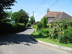 A street of Swingfield | |
 Swingfield Location within Kent | |
| Population | 1,227 (2011)[1] |
| District |
|
| Shire county | |
| Region | |
| Country | England |
| Sovereign state | United Kingdom |
| Post town | Dover |
| Postcode district | CT15 |
| Police | Kent |
| Fire | Kent |
| Ambulance | South East Coast |
| UK Parliament | |

Swingfield is a village and civil parish in the district of Folkestone and Hythe[2] in Kent, England. The parish includes the settlements of Densole and Selsted.
The place-name 'Swingfield' is first attested in 1202 in the Curia Regis Rolls, and in 1242 in the Book of Fees, in both instances appearing as Swinesfeld. The name means "pigs' field or open land".[3]
The village is located approximately 5 miles north of Folkestone on the North Downs. Notable buildings include St Peter's Church and Swingfield Preceptory.
The tower of St Peter's Church was a measuring point for the Anglo-French Survey (1784–1790) linking the Royal Greenwich Observatory and the Paris Observatory.
References[]
- ^ "Civil Parish population 2011". Retrieved 1 April 2017.
- ^ Ordnance Survey linked data
- ^ Eilert Ekwall, The Concise Oxford Dictionary of English Place-names, p.457.
External links[]
![]() Media related to Swingfield at Wikimedia Commons
Media related to Swingfield at Wikimedia Commons

Categories:
- Villages in Kent
- Civil parishes in Kent