Wingmore
| Wingmore | |
|---|---|
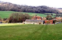 Wingmore Court Farm | |
 Wingmore Location within Kent | |
| District |
|
| Shire county | |
| Region | |
| Country | England |
| Sovereign state | United Kingdom |
| Post town | Canterbury |
| Postcode district | CT4 |
| Police | Kent |
| Fire | Kent |
| Ambulance | South East Coast |
| UK Parliament | |
Wingmore is a small village between Canterbury and Folkestone in Kent, England.[1] It is situated in the Elham Valley approximately halfway between the larger villages of Elham and Barham on the B2065. It consists of a few cottages and farms. The population at the 2011 Census was included in the civil parish of Elham
References[]
- ^ Ordnance Survey: Landranger map sheet 179 Canterbury & East Kent (Dover & Margate) (Map). Ordnance Survey. 2013. ISBN 9780319228784.
External links[]
![]() Media related to Wingmore at Wikimedia Commons
Media related to Wingmore at Wikimedia Commons

This Kent location article is a stub. You can help Wikipedia by . |
Categories:
- Villages in Kent
- Kent geography stubs