Szarvas
Szarvas
Sarwasch (in German) Sarvaš (in Slovak) | |
|---|---|
 Old Lutheran church (1786-1788) | |
 Flag  Coat of arms | |
 Szarvas | |
| Coordinates: 46°51′50″N 20°33′25″E / 46.864°N 20.557°E | |
| Country | |
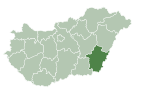
| County | Békés |
| District | Szarvas |
| Area | |
| • Total | 161.57 km2 (62.38 sq mi) |
| Population (2011) | |
| • Total | 16,954 |
| • Density | 114.35/km2 (296.2/sq mi) |
| Time zone | UTC+1 (CET) |
| • Summer (DST) | UTC+2 (CEST) |
| Postal code | 5540 |
| Area code | (+36) 66 |
| Website | www |


Szarvas (German: Sarwasch, Slovak: Sarvaš; IPA: [sarvaʃ]) is a town in Békés County, Hungary.
Name[]
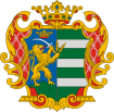
Placename Szarvas originated from the old Hungarian word szarvas, which means deer. Deer also can be found in the coat of arms of the town.
Location[]
Szarvas is located in the Great Hungarian Plain upon the Körös River, 170 km (106 mi) southeast from Budapest. Highways 44 and 443, and the Mezőtúr-Orosháza-Mezőhegyes railway line also cross the town.[1] The geographic centre of Hungary was near Szarvas before the Treaty of Trianon; a memorial in a windmill shape now marks that location in a park on a bank of the Körös River across from the Arboretum.[2][3][4]
History[]
According to the Hungarian Royal Treasury (Hungarian: Magyar Királyi Kincstár) it was an ethnic Hungarian town in 1495.[5] The Medieval town was ruined due to the Ottoman wars, native Hungarian population fled from the area.[5] It was uninhabited until 1720, when Austrian baron Johann Georg Freiherr von Harruckern (György János Harruckern) invited mainly Slovak settlers from Upper Hungary to the deserted area. They built a brand new town by the help of , who invited engineers to plan the town.[6] Tessedik also established the first agricultural school in Hungary. Lutheran church was built from 1786 to 1788, the Roman Catholic from 1808 to 1812. Town hall was built in 1820.[6] Hungarians overtook Slovaks in the 1920s, become the majority according to the census was held in 1930.[5]
Since 1990 Szarvas is home to the Ronald S. Lauder Szarvas International Jewish Youth Camp (Hungarian: Szarvasi Nemzetközi Zsidó Ifjúsági Tábor).[7]
Demographics[]
According to the 2011 census the total population of Szarvas was 16,954, of whom there were 14,325 (84.5%) Hungarians, 1,822 (10.8%) Slovaks, 489 (2.9%) Romani and 75 (0.4%) Germans by ethnicity. 15.4% did not declare their ethnicity,[8] excluding these people Hungarians made up 99.9% of the total population. In Hungary people can declare more than one ethnicity, so some people declared a minority one along with Hungarian.[9][10]
In 2011 there were 4,531 (26.7%) Lutheran, 2,601 (15.3%) Roman Catholic and 708 (4.2%) Hungarian Reformed (Calvinist) in Szarvas. 4,087 people (24.1%) were irreligious and 200 (1.2%) Atheist, while 4,601 people (27.1%) did not declare their religion.[9]
Sights[]
- Szarvas Botanical Garden (Szarvasi Arborétum)
- Bolza Castle (Bolza-kastély)
- Dry Mill (Szárazmalom)
- Sámuel Tessedik Muzeum (Tessedik Sámuel Múzeum)
- Szarvas Spa (Szarvasi Gyógyfürdő)
- Csáky Castle (Csáky-kastély)
- Mitrovszky Castle (Mitrovszky-kastély)
- György Ruzicskay Art House (Ruzicskay György Alkotóház)
- Lutheran Old Church (Evangélikus ótemplom)
- New Lutheran Church (Evangélikus újtemplom)
- Slovak Country House (Szlovák tájház)
Notable people[]
- Roland Lipcsei (1984), Hungarian football player
- Éva Novodomszky (1974), Hungarian journalist and presenter
- Endre Bajcsy-Zsilinszky (1886-1944), Hungarian politician
Sport[]
- Szarvasi FC, association football club
Twin towns – sister cities[]
References[]
- ^ Magyarország autóatlasz, Dimap-Szarvas, Budapest, 2004, ISBN 963-03-7576-1
- ^ "Historical Centre of Hungary and Memorial Track - National Parks". About Hungary. Hungarian Tourism Ltd. Retrieved 29 September 2014.
- ^ "Geographical center of Hungary". Chesereu Reformed Church. Retrieved 29 September 2014.
- ^ "Arboretum of Szarvas, Szarvas, 5540 Hungary, 46.876976, 20.536938". Google Maps. Google. Retrieved 29 September 2014.
- ^ Jump up to: a b c Károly Kocsis (DSc, University of Miskolc) – Zsolt Bottlik (PhD, Budapest University) – Patrik Tátrai: Etnikai térfolyamatok a Kárpát-medence határon túli régióiban, Magyar Tudományos Akadémia (Hungarian Academy of Sciences) – Földrajtudományi Kutatóintézet (Academy of Geographical Studies); Budapest; 2006.; ISBN 963-9545-10-4, CD Atlas
- ^ Jump up to: a b Antal Papp: Magyarország (Hungary), Panoráma, Budapest, 1982, ISBN 963 243 241 X, p. 860, pp. 448-449
- ^ Website of the Szarvas International Jewish Youth Camp
- ^ Gazetteer of Hungary / Szarvas
- ^ Jump up to: a b 2011 Hungarian census, Békés county
- ^ Hungarian census 2011 - final data and methodology
- ^ "Testvérvárosok". szarvas.hu (in Hungarian). Szarvas. Retrieved 2021-04-09.
External links[]
| Wikimedia Commons has media related to Szarvas. |
- Official website in Hungarian and English
- Aerial photographs of Szarvas
Coordinates: 46°52′N 20°33′E / 46.867°N 20.550°E
| show Authority control |
|---|
- Populated places in Békés County
- Slovak communities in Hungary