Tamazula de Victoria
Tamazula de Victoria | |
|---|---|
Municipal seat and city | |
|
Seal | |
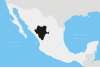
 Tamazula de Victoria Location in Mexico | |
| Coordinates: 24°58′12″N 106°57′56″W / 24.97000°N 106.96556°W | |
| Country | |
| State | Durango |
| Municipality | Tamazula |
| Government | |
| • Municipal President | Jose Angel Beltran |
| Elevation | 245 m (804 ft) |
| Population (2010) | |
| • Total | 2,337 |
| Time zone | UTC-6 (CST) |
| • Summer (DST) | UTC-5 (CDT) |
| Postalcode | 34580 |
| Website | http://www.tamazuladgo.gob.mx/index.html |
Tamazula de Victoria is a small town and seat of the municipality of Tamazula in the Mexican state of Durango, near the Sierra Madre Occidental mountains. The town is located about 1.5 hours east of Culiacán, Sinaloa. General Guadalupe Victoria, the first president of Mexico, was born there, hence the name. Its official name is Tamazula de Victoria. As of 2010, the town had a population of 2,337[1] The Tamazula River runs directly north of the town.

Cactus Cardon Guajiro and Corn at Sunset after a summer thunderstorm in Tamazula, Durango
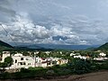
Hillside view looking East

Templo San Ignacio de Layola Catholic Church

Interior view of San Ignacio de Layola Catholic Church altar in 2013

1786 Birthplace and childhood home of Guadalupe Victoria. Now a museum


Villages[]
The municipal subdivisions of Tamazula are:
- Amaculi
- Los Remedios
- El Chicural
- El Cocoyole
- Chacala
- El Llano
- El Comedero
- Las Juntas
- Las Quebradas
- El Río
- Pueblo Viejo
- El Carrizo
- Otatitlán
- Las Coloradas
- Santa Elena
- El Cajón
- La Mesa del Rodeo
- El Durazno
- La Alameda
- Santa Gertrudis
- El Tecuán
- Santa Barbara
- Cuesta Blanca
References[]
- ^ "Tamazula". Catálogo de Localidades. Secretaría de Desarrollo Social (SEDESOL). Retrieved 23 April 2014.
Coordinates: 24°58′12″N 106°57′56″W / 24.97000°N 106.96556°W
- Populated places in Durango
- Durango geography stubs