Culiacán
Culiacán Rosales | |
|---|---|
 Coat of arms | |
| Nickname(s): La Perla del Humaya (The Pearl of the Humaya) | |
 Culiacán Rosales Location in Sinaloa | |
| Coordinates: 24°48′25″N 107°23′38″W / 24.80694°N 107.39389°WCoordinates: 24°48′25″N 107°23′38″W / 24.80694°N 107.39389°W | |
| Country | Mexico |
| State | Sinaloa |
| Municipality | Culiacán (seat) |
| Foundation | 1531 |
| • Mayor | (MRN) |
| Area | |
| • City | 65 km2 (25 sq mi) |
| Elevation | [1]71 m (233 ft) |
| Population (2019) | |
| • Urban | 1,003,500 metropolitan area |
| • Demonym | Culiacanense / "culichi" |
| Time zone | UTC−7 (MST) |
| • Summer (DST) | UTC−6 (MDT) |
| Waterways | Tamazula River, Humaya River, Culiacán River |
| Airports | Federal de Bachigualato International Airport |
| Public transit | RedPlus |
| Railroads | Ferromex Culiacán Station |
| Website | www |


Culiacán, officially Culiacán Rosales, is a city in northwestern Mexico that is the capital of and the largest city in Sinaloa and in the Culiacán Municipality. It was founded on September 29, 1531 by the Spanish conquerors and Nuño Beltrán de Guzmán under the name of Villa de San Miguel, which referred to its patron saint, Michael the Archangel.
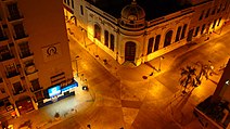
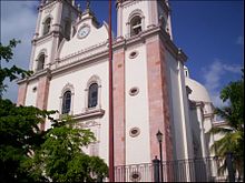
Culiacán is well known for its culture, luxuries, and celebrations. Its iconic sites include its historic center, Las Riberas Park, the flag or better known as dancing fountains and religious temples such as its Basilica Cathedral, the sanctuary, and the Lomita. The modern Tres Ríos district is known for its buildings, squares, hotels, parks, restaurants, schools, etc.
The city is in a valley on the slopes of the Sierra Madre Occidental, at the confluence of the Tamazula and Humaya Rivers, where both join to form the Culiacán River 55 m above sea level.
The first outline of the city was made by the architect Luis F. Molina.
Etymology[]
The genuine Aztec name of the Nahuatl language is Colhuacán or Culhuacán, which is from colhua or culhua and can, which is a place, and its meaning varies according to different historians:
- "snake place"
- "crooked hill"
- "where walkers twist the path"
The most respected theory is "place of the colhuas", that is "inhabited by the colhua tribe", and the most frequent meaning is "place of worshiping the God Coltzin".[2]
History[]
Prehispanic era[]
In ancient times, there was an indigenous population called Huey Colhuacan that dates back to Tecpatl, which corresponds to the year 628 of our era; the Aztecs built it during their pilgrimage. Its exact location is unknown, but it is assumed that it was close to the current town of Culiacancito. Here he was born in 1065 A.D. the cult of Huitzilopochtli, the warrior god of Aztec mythology.[3] The ancient settlers were called Culichis.
Founding[]
The city that we know today as Culiacán was co-founded in 1531 by and Nuño Beltrán de Guzmán under the name of Villa de San Miguel. Upon their arrival in the 16th century, the Spanish found the existence of farmhouses organized in indigenous nations by the tribe of the , which brought together a group of people of the same origin and language who had a common tradition.
Other indigenous peoples that inhabited the original territory of Culiacán were the , , and .
After their war of conquest, Lázaro de Cebreros and Nuño Beltrán de Guzmán (1531), organized the territories acquired in three provinces, one of them was Culiacán which was delimited, to the south, by the Elota river and in the north by the Mocorito River, depending on the . Organized in this way, it lasted until 1786, the year in which the administration system was implemented, with Sonora and Sinaloa forming the administration of Arizpe and the ancient province of Culiacán gave life to the party of the same name with equal jurisdiction.
Independent Mexico[]
On October 6, 1821, Independence was sworn in Culiacán. Culiacán is granted the category of city, on July 21, 1823, when the provinces of Sonora and Sinaloa separated by decree from Congress. In 1824, by , Sinaloa and Sonora meet again, forming the state of the West. In 1830, the provinces of Sonora and Sinaloa were definitively separated, by decree of October 13, 1830, the city of Culiacán being designated capital of the state of Sinaloa. Later, during the conservative government related to the French Intervention in 1861, prefectures were installed and the Municipalities Law was decreed that divided the Districts into City Councils. The Badiraguato District was suppressed and became part of the Culiacán District as a Municipality.
From 1859 to 1873 it ceased to be the capital of Sinaloa, which moved to Mazatlán. Already in the Restored Republic, Governor Eustaquio Buelna confronted the merchants of the port. He returned to Culiacán and the Local Congress gave him the status of capital of the state.
Porfirian and revolutionary times[]
For 1878, Culiacán had three City Halls, whose headwaters were Culiacán, and Badiraguato, it remained that way until in 1880 Badiraguato returned to being a district with the limits that previously corresponded to it.
1912 was the year in which the Municipalities were established by law as a new form of internal government, but it was until 1915 that the Political Directories were suppressed, this law coming into force, causing the Districts to become free municipalities.
Culiacán was established as a Municipality by decree published on April 8, 1915, comprising within its limits the current Municipality of Navolato that was segregated in 1982, according to a decree of August 27 of that year, thus losing 2,285 km² of the valley agricultural.

Some time later, the State Congress approved the extension of the name of the capital city, giving it its current official name, Culiacán de Rosales, in honor of the great Mexican military man, .
After World War II[]
Beginning in the late 1950s, Culiacán became the birthplace of an incipient underground economy based on illicit drugs exported to the United States. The completion of the Pan-American Highway and the regional airport in the 1960s accelerated the expansion of a workable distribution infrastructure for the enterprising few families that would later come to dominate the international drug cartels along Mexico's Pacific Northwest. The Sinaloa Cartel made Culiacán its primary base.
On October 17, 2019, after an ultimately unsuccessful attempt to arrest one of the cartel leaders, widespread gunfights broke out across the city, leading to multiple deaths, in what has been called the "Battle of Culiacán".
Coat of arms[]
The coat of arms of the municipality and the city of Culiacán in Sinaloa, Mexico, has various elements that represent the history of the municipality yesterday and today.
Rolando Arjona Amábilis was the one who drew up the official coat of arms of the Municipality of Culiacán, which was made official, through municipal decree number May 13, 26, 1960 and published in number 90 of the Official Newspaper of the State of Sinaloa on July 30, 1960.

Its shape is square with rounded corners, ending in a point. The entire "field" of the shield covered with a reddish color of earth, is occupied by a hieroglyph representing a hill with a human head on top, very inclined forward and which alludes to Coltzin, "the crooked god", an authentic figure of the Nahuatl mythology, which gave name to a Nahuatlaca-Colhua tribe and this, in turn, to the town of its residence, Colhuacán or Teocolhuacán.
Behind the hieroglyph to the right, there are symbols of water referring to rivers; On the same hieroglyph, in the central part and towards the left side, there is a cross followed by a path on which footprints can be observed, which end in a small construction, motifs that symbolize the missionaries of San Miguel de Culiacán left for the north and they are invoked as an obligatory tribute to the goodness and heroism of the missionaries.
On the carmine border, the word "Culiacán" can be read in its upper part and in its lower part the word "Colhuacán" which corresponds to the true name of the place in the Nahuatl language. In the upper part of the shield there is a hill with a germinating seed and on it, the figure of a golden sun that alludes both to the tropical climate of this region and to the fundamentally agricultural effort of its inhabitants.[4]
Politics[]

The government of the municipality of Culiacán corresponds to its City Council, this is elected a universal, direct and secret vote for a period of three years that are not renewable for the immediate period but if not continuously and that begins to exercise its position on the day January 1 of the year following your election; The city council is integrated by the Municipal President into a Procurator Trustee and the body of councilors made up of 18 representatives, once they are elected by relative majority and seven by the principle of proportional representation.
Syndications[]
For its internal regime, the municipality is subdivided into 17 receiverships, which in turn are divided into police stations, the 17 receiverships of the municipality are: El Salado, Higueras de Abuya, Baila, Aguaruto, Emiliano Zapata, Adolfo López Mateos (El Tamarindo), Jesús María, Las Tapias, Quilá, Sanalona, San Lorenzo, Tacuichamona, Tepuche, Imala, Costa Rica, Culiacancito and Eldorado.
Paramunicipals[]
- Culiacan Zoo
- JAPAC
- Municipal Institute of Sports and Physical Culture (IMDEC)
- EME Park (87)
- Municipal Institute of Culiacán Women (IMMUJERES)
- MIA Institute (MIA Museum & MIA Auditorium)
- Culiacán Municipal Institute of Culture (IMCC)
- Housing Institute
- DIF Culiacan
- The Chronicle of Culiacán
- Municipal Institute of Youth (IMJU)
- Municipal Commission of Populated Centers of Culiacán (COMUN)
- IMPLAN
- COMPAVI
Geography[]

Location[]
It is located in the central region of the State of Sinaloa, forming part of the northwest of Mexico. The coordinates correspond to it: 24 ° 48'15 "N (north latitude) and 107 ° 25'52" W (west longitude), with an altitude of 54 meters above sea level.[5]
It is located 1,240 km from Mexico City, from Culiacán to Tepic, there are only 502 km; to Durango, 536 km; to Hermosillo, 688 km; to Guadalajara, 708 km; to Monterrey, 1,118 km; Chihuahua, 1,159 km; to Tijuana, 1,552 km; and to Matamoros, 1,434 km.[6]
Relief and hydrography[]
The relief of the municipality is well defined by a mountainous part and the coastal plain; the physiographic region of the highlands is a relatively large portion that is part of the Pacific slope of the Sierra Madre Occidental, which has heights of 300 to 2,100 meters above sea level.[7] The municipality of Culiacán is crossed by four hydrological currents: the Humaya, Tamazula, Culiacán and San Lorenzo rivers; Humaya has its origin in the State of Durango, entering Sinaloa through the municipality of Badiraguato; its waters are controlled by the dam Licenciado Adolfo López Mateos. The Tamazula River rises in the Sierra Madre Occidental near the Topia Valley; its current is controlled by the Sanalona dam; the Humaya and Tamazula rivers unite in front of the city of Culiacán to form the Culiacán River, which finally empties into the Gulf of California; the San Lorenzo river is born in the Sierra Madre Occidental within the State of Durango, enters Sinaloa through the municipality of Cosalá and empties into the Gulf of California.
Climate[]

Culiacán has a hot semi-arid climate (Köppen: BSh), despite receiving an annual rainfall over 600 mm (24 in), due to its hot temperatures and high evaporation. Summers are very hot and humid, shade temperatures can reach 45 °C (113 °F) and high humidity can produce heat indices of 50 to 55 °C (122 to 131 °F), with the risk of heavy rainfall from decaying tropical cyclones also present. Winters are much milder with less humidity and an average high of 27 °C, with warm nights.
| hideClimate data for Culiacán (1951–2010) | |||||||||||||
|---|---|---|---|---|---|---|---|---|---|---|---|---|---|
| Month | Jan | Feb | Mar | Apr | May | Jun | Jul | Aug | Sep | Oct | Nov | Dec | Year |
| Record high °C (°F) | 41.0 (105.8) |
42.0 (107.6) |
39.0 (102.2) |
41.5 (106.7) |
41.5 (106.7) |
45.5 (113.9) |
42.5 (108.5) |
46.0 (114.8) |
41.5 (106.7) |
41.5 (106.7) |
42.5 (108.5) |
37.0 (98.6) |
46.0 (114.8) |
| Average high °C (°F) | 27.8 (82.0) |
28.9 (84.0) |
30.5 (86.9) |
32.8 (91.0) |
34.9 (94.8) |
35.9 (96.6) |
35.5 (95.9) |
34.8 (94.6) |
34.4 (93.9) |
34.2 (93.6) |
31.5 (88.7) |
28.2 (82.8) |
32.5 (90.5) |
| Daily mean °C (°F) | 19.4 (66.9) |
20.1 (68.2) |
21.3 (70.3) |
23.6 (74.5) |
26.4 (79.5) |
29.5 (85.1) |
29.8 (85.6) |
29.3 (84.7) |
29.0 (84.2) |
27.5 (81.5) |
23.5 (74.3) |
20.2 (68.4) |
25.0 (77.0) |
| Average low °C (°F) | 10.9 (51.6) |
11.3 (52.3) |
12.1 (53.8) |
14.5 (58.1) |
18.0 (64.4) |
23.2 (73.8) |
24.1 (75.4) |
23.8 (74.8) |
23.6 (74.5) |
20.7 (69.3) |
15.6 (60.1) |
12.2 (54.0) |
17.5 (63.5) |
| Record low °C (°F) | 2.0 (35.6) |
2.0 (35.6) |
3.0 (37.4) |
3.0 (37.4) |
9.0 (48.2) |
12.0 (53.6) |
13.0 (55.4) |
16.0 (60.8) |
17.0 (62.6) |
11.0 (51.8) |
5.0 (41.0) |
3.0 (37.4) |
2.0 (35.6) |
| Average rainfall mm (inches) | 18.4 (0.72) |
11.7 (0.46) |
2.8 (0.11) |
2.4 (0.09) |
1.1 (0.04) |
19.7 (0.78) |
162.8 (6.41) |
209.2 (8.24) |
141.6 (5.57) |
50.0 (1.97) |
21.3 (0.84) |
26.3 (1.04) |
667.3 (26.27) |
| Average rainy days (≥ 0.1 mm) | 2.2 | 1.4 | 0.6 | 0.4 | 0.2 | 2.4 | 13.8 | 14.8 | 10.8 | 2.9 | 1.6 | 2.2 | 53.3 |
| Average relative humidity (%) | 72 | 70 | 67 | 65 | 64 | 67 | 72 | 75 | 75 | 72 | 71 | 72 | 70 |
| Mean monthly sunshine hours | 189.1 | 186.5 | 229.4 | 213.0 | 248.0 | 222.0 | 192.2 | 198.4 | 195.0 | 229.4 | 213.0 | 182.9 | 2,498.9 |
| Mean daily sunshine hours | 6.1 | 6.6 | 7.4 | 7.1 | 8.0 | 7.4 | 6.2 | 6.4 | 6.5 | 7.4 | 7.1 | 5.9 | 6.8 |
| Source 1: Servicio Meteorológico Nacional (humidity 1981–2000)[8][9][10] | |||||||||||||
| Source 2: Deutscher Wetterdienst (sun, 1941–1970)[11] | |||||||||||||
Demographics[]
Population dynamics[]

The Municipality of Culiacán has a total population of 858,638 inhabitants, this according to the 2010 Population and Housing Census carried out by the National Institute of Statistics and Geography (INEGI).[12] It has a population density of 166.8 inhabitants / km2,[13] the Municipality concentrates 31% of the population in the State of Sinaloa, with 422,507 men and 436,131 women, with a ratio of 96.9 men for every 100 women.[12]
The city of Culiacán Rosales occupies only a part of the municipality of Culiacán and in 2010 had an urban area of 65 km2, being the largest in the state of Sinaloa and has a population of 675,773 inhabitants (of which 329,608 are men and 346,165 are women), according to the 2010 Population and Housing Census carried out by the (INEGI), resulting in a population density of 10,396.5 inhabitants / km2.[14] concentrating 78.7% of the total urban population of the Municipality. The ethnic groups most represented in the Municipality are the Mixtec and Nahuatl,[15] the total population of indigenous language speakers (HLI population) is 13,081 people.[16] On the other hand, in the urban area of Culiacán, there are only 3,536 indigenous people, representing a very low percentage with respect to the total; Furthermore, these indigenous groups are not native to the municipality or the entity, since they were exterminated, displaced or assimilated by the mestizo population.
The city ranks 20th in number of foreign population, which amounts to 6,693 inhabitants, which represent almost 1% of the total population; Among the main nationalities we find Americans, Canadians, Spanish, Italians, Greeks, Argentines, Cubans, Colombians, Brazilians, Chinese, Japanese, Russians, Ukrainians, Venezuelans, Dominicans, Germans, among others.
It should be noted the presence of people of Greek origin that occurred in the 1940s and 1950s, which coincide with the incipient but flourishing emergence of agriculture, which attracted a lot of Hellenic labor for the tillage of the land, seeing that it was a profitable business, they communicated it to their family and friends, which attracted a greater number of people; today they have inherited a legacy to their children, grandchildren and great-grandchildren that make up the few thousand people who continue to live in the city. It is believed that the Greek community is the largest in Mexico and the best organized, the president of said community is in charge of Basilio Karamanos Pérez.
| Year | 1900 | 1910 | 1920 | 1930 | 1940 | 1950 | 1960 | 1970 | 1980 | 1990 | 1995 | 2000 | 2005 | 2010 | 2015 | 2020 |
|---|---|---|---|---|---|---|---|---|---|---|---|---|---|---|---|---|
| Population | 10,380 | 13,527 | 16,034 | 18,202 | 22,025 | 48,936 | 85,024 | 167,956 | 304,286 | 415,046 | 505,518 | 540,823 | 605,304 | 675,673 | 858,638 | 1,405,007 |
Housing and urbanism[]
The total number of dwellings that exist in the city are 221,144 of which only 176,799 dwellings are occupied with an average of 3.81 inhabitants per inhabited dwelling. In general, cement roofs, walls and floors are used for the construction of the house, although homes or buildings do not cease to exist, most of them have sheet roofs and earth floors, this occurs mainly in the area peripheral to the south of the city, where the humble settlements of new inhabitants who arrive with the hope of obtaining a better quality of life proliferate.

Of the 176,799 occupied dwellings, 173,704 have electricity; 171,614 have piped water; 171,489 have drainage and 169,550 have the 3 services simultaneously.
The city has many buildings, among the most noteworthy are, Torre Tres Ríos, Torre Santa María, Torre Tres Afluencias, Mileto 4 Ríos, Estela Corporate Center, Ceiba, BioInnova Building, Tower 120 and Dafi, all located in one of the most important districts of the city, the Tres Ríos Urban Development.
City zoning[]
The city is divided into different areas mainly:
The Historical Center of Culiacán is the original area of the city, in which most of the buildings of the Spanish colonization between the 16th and 19th centuries are found, it comprises a territorial extension of approximately 247,123 ha (2,471 km²). From the '70s onwards, there was a process of depopulation of the area due to the high costs of rents, the bustle of the main streets and avenues and the priority of having more commercial spaces, but in recent years there has been a process of repopulation of the same with the construction of apartments in the periphery of the Center and a project of urban reorganization in which it is intended to have a higher population density.
Las Colonias, which are the first settlements that were populating the perimeter around the original urban area by people from different social strata to have a largely wide space close to the Center; Among the best known and with the largest number of population we find: Infonavit Humaya, Tierra Blanca, January 6, Stase, Juntas de Humaya, Almada, Miguel Alemán, Centro Sinaloa, Morelos, Palmito, El Barrio, Aurora, etc.
The subdivisions for their part are places divided by different construction companies, in which there are in certain sections, the same style of housing, housing people of lower middle class, middle and upper middle class, among the best known are: La Conquista, Villas del Rio, Valle Alto, Los Pinos, Villa Verde, Villa Fontana, etc.
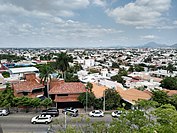
Residentials are considered to be areas strategically built for people with high purchasing power, with spacious houses, large green areas and in most cases, they are delimited as private, and we find: Tres Ríos, Chapultepec, Los Álamos, Guadalupe, Lomas de Guadalupe, Colinas de San Miguel, Montebello, La Campiña, Las Quintas, Isla Musalá, La Primavera, etc.
Independent of these areas, we find one that stands out for its extension and its level of influence at the state level: the Tres Ríos Urban Development, which was started in 1990 with the aim of creating a better commercial, residential and entertainment area. for the city, in addition to taking advantage of the lands adjacent to the Culiacán, Humaya and Tamazula rivers, in addition to embellishing the banks with vegetation and a new boardwalk.
Parks and green areas[]
The green areas are located in different areas of the city; In recent years, the municipal and state government have been concerned with protecting, safeguarding, and increasing green lungs, to provide a better quality of life for Culiacans and tourists; it has the following:
Las Riberas Park[]

Parque Las Riberas (in Spanish) is the area attached to the Tamazula and Humaya rivers. Different species of trees such as willows, poplars, guamúchiles, and eucalyptus, can be seen. The White Bimodal bridg,e which connects the park with the city center, facilitates access for pedestrians and at night it becomes a light show that contrasts with the Black Bridge in Culiacán.
Culiacán Botanical Garden[]

Located to the east of the city, this area comprises 10 ha and is home to different ecosystems and hundreds of plant and tree species. The Culiacán Botanical Garden has a variety of more than 2,000 plants. It is known because here runners and cyclists choose to take the morning walk, the prohibition of dogs on the path of plants stands out. Many photographers flock to this garden to capture young quinceañeras and newlyweds.
Orabá Island[]
Orabá Island, as its name indicates, is an island between the confluence of the Tamazula River and the Humaya River, where the Culiacán River is born. It is part of a series of parks and gardens that have been built on the banks of the three rivers. From very early on, many people come to exercise, walk, run, ride a bicycle or simply take a walk among the large trees.
Culiacán Zoo[]
Located next to the heart of the city, forming part of the Civic Center Constitución with an extension of 13.5 hectares; which houses 1,400 animals belonging to more than 450 species including mammals, reptiles and birds. It was built on December 14, 1950, as part of the Development Plan of the Sinaloa State Government, which contemplated the need to create a natural area that would contribute to promoting the education of flora and fauna existing in this region under the mandate of the State Governor. General Gabriel Leyva Velásquez, supported by Mr. Emilio Aguerreverre, Municipal President of Culiacán.
Tres Ríos water park[]
The Tres Ríos Water Park is a recreational space that was built at the confluence of the Humaya and Tamazula rivers, precisely where the Culiacán River is born.
This park is very close to Parque Las Riberas. It is the largest and most visited park in the northwest of the country.
This park is very visited thanks to its views of the Black Bridge and the Culiacán River.
Dancing fountains[]
The dancing or dancing fountains of Culiacán are a spectacle of hundreds of independent fountains programmed to "dance" to the sound of typical Sinaloan music. This show is presented every day in an area of the 3 Ríos Project where the flagpole is located, more specifically, at the mere confluence of the Humaya and Tamazula rivers.
The shows are always given twice at night and always at the same time, and they are a tourist attraction in Culiacán.
Park 87[]
Located on Av. México 68, República Mexicana. The park has as attractions, slides, swimming pools, zip lines, the garden of peace.
Obregón Square[]

Located on Álvaro Obregón Avenue, you can enjoy a pleasant stay thanks to its lush trees that prevent you from feeling the overwhelming heat of the city. Also, you can find candy and food stalls in the surroundings of the area, as well as a small book stand. Besides, the square comes alive in the weekends afternoons, where there is live music and many people (mostly the elderly or seniors) dance to the rhythm of the songs.
Rosales Square[]
Located next to the Rosalina house, which has diverse vegetation, it is a space with colonial architecture that offers pedestrians a rest from the busy rhythm of life in the city.
Economy[]
Culiacán's economy is mainly agricultural and commerce, being a trade center for produce, meat, and fish. Among other industries, Culiacán represents 32 percent of the state economy.
Coppel, Casa Ley, Homex and other companies of national importance are headquartered in Culiacan.
The Sinaloa Cartel, a drug-trafficking and organized crime syndicate, is based in Culiacán.[17]
Administrative divisions[]
Culiacán is divided into 27 sectors (sectores), which are groups of several quarters (colonias):
| Administrative divisions of Culiacán | ||
 |
Demarcaciones territoriales | Sector |
| Riberas | 01 | |
| Centro (primer cuadro) | 02 | |
| Las Quintas | 03 | |
| Isla Musalá | 04 | |
| Universitarios | 05 | |
| Tres Ríos | 06 | |
| Patio de Maniobras | 07 | |
| Juntas del Humaya | 08 | |
| Río Culiacán | 09 | |
| Guadalupe | 10 | |
| Colinas de San Miguel | 11 | |
| Abastos | 12 | |
| El Barrio | 13 | |
| Los Ángeles | 14 | |
| Mirador Tamazula | 15 | |
| Humaya | 16 | |
| La conquista | 17 | |
| Bacurimi | 18 | |
| Villas del Río | 19 | |
| Bachigualato | 20 | |
| Díaz Ordaz | 21 | |
| Barrancos | 22 | |
| San Isidro | 23 | |
| Loma de Rodriguera | 24 | |
| La Higuerita | 25 | |
| Aguaruto | 26 | |
| La Costerita | 27 | |
Media[]
The newspaper El Debate and is published in Culiacán.
Education[]


Universities[]
- Centro de Estudios Universitarios Superiores (CEUS)
- Instituto Tecnológico de Culiacán
- Instituto Tecnológico y de Estudios Superiores de Monterrey (ITESM) – Campus Sinaloa
- Universidad Asia-Pacifico
- Universidad Autónoma de Durango-Campus Culiacán
- Universidad Autónoma de Sinaloa
- Universidad Casa Blanca
- Universidad Católica de Culiacán
- Universidad Golfo de México – Campus Culiacán
- Universidad México Internacional
- Universidad de Occidente – Campus Culiacán
- Universidad de San Miguel (USM)
- Universidad TecMilenio – Campus Culiacán
- Universidad Tecnológica de Sinaloa
- Universidad Valle del Bravo – Campus Culiacán
- Universidad de Veracruz – Campus Culiacán
- Universidad Tecnológica de Culiacán
- Instituto Chapultepec is known as the best school in the city, important people goes there, such as Maximiliano Mendez
Transportation[]
The Terminal de Autobuses de Culiacán or Central de Autobuses Culiacán Millenium is a bus terminal located west of the city of Culiacán, Sinaloa, Mexico. The station is built in front of the Country Club. This plant replaced the old plant that was to the south, in front of Blvd. Gabriel Leyva Solano.
Transit system[]
Urban transport[]
At present[when?], Culiacán has just over 68 urban transport routes, which serve about one million users. The Culiacán urban transport is operated by RedPlus.
Rail[]
The city has a train station, operated by Ferromex, and it is used only to transport freight. It is connected to south with Mazatlán and north with Guaymas.
Bus station[]
Culiacán uses the Central Internacional de Autobuses "Millennium" ("Millennium" International Buses Station) to travel across all Mexico (north, central, and south) and to the United States (Arizona and California). This replaced the old bus terminal in the southern city.
Roads and expressways[]
Though several high-speed roads have been built, most of the city's streets are rather narrow and traffic jams are common at rush hours. Now, 300,000 cars are in Culiacan, making the per capita number of cars one of the highest in the country considering the 745,000 inhabitants.
Main roads[]
Culiacán has several roads (avenues, boulevards, streets, etc.), but some of these are the main quick connection to other points of the city.
- Álvaro Obregón Ave
- Francisco I. Madero Blvd.
- Paseo Niños Heroes
- El Dorado Ave
- Aeropuerto
- Emiliano Zapata Blvd.
- Benjamín Hill Ave
- Calzada de las Torres
- México 68
- Plan Mar de Cortes
- Heroico Colegio Militar
- Revolución Ave
- Sanalona Way
- Rolando Arjona Amabilis Blvd.
- Universitarios
- José Limón Blvd.
- Las Américas
- Diego Valadez Ríos
- Manuel J. Clouthier
- Miguel Hidalgo y Costilla
- José Vasconcelos
- Gabriel Leyva Solano Blvd.
- Xicoténcatl
- Josefa Ortíz de Domínguez
- Enrique Sanchez Alonso Blvd.
- De los Insurgentes
- Pedro Infante Blvd.
- Rotarismo Road
- Ciudades Hermanas
- Patria Ave
- Constituyentes Emiliano García
- Nicolás Bravo
- 21 de Marzo Ave
- Las Minas
Bridges and tunnels[]
The city has a total of 13 bridges: six across the Tamazula River, two spanning the Humaya River, and the longest one with other four crossing the Culiacán River. Efforts to solve traffic problems have been made, but most of the city streets and bridges are now crowded and insufficient to handle regular and rush hours traffic; a 40-km/h speed limit in most parts of the city worsens the situation.
- Musalá Bridge (Tamazula River)
- Musalá-Universitaria Bridge (Tamazula River)
- Benito Juárez Bridge (Tamazula River)
- Morelos Bridge (Tamazula River)
- Miguel Hidalgo Bridge (Tamazula River)
- Juan de Dios Bátiz-Tres Ríos Bridge (Tamazula River)
- Josefa Ortíz de Domínguez Bridge (Humaya River)
- Rafael Buelna Bridge (Humaya River)
- Jorge Almada Bridge (Culiacán River)
- Black Rail Bridge (Culiacán River)
- Rolando Arjona Amabilis-UDO (Culiacán River)
- USE-Valle Alto (Culiacán River)
- Libramiento Recursos (Rosales Channel)
- Eje Federalismo Bridges (Rosales Channel)
- Chavez Castro Bridge (Rosales Channel)
- Emiliano Zapata Pass Bridge (Rosales Channel)
Also, Culiacán has bridges in streets conforming to high transit systems in places where the rush hour is common.
- Zapata (Blvd. Emiliano Zapata)
- 280-Aeropuerto (Blvd. Aeropuerto)
- Eje Aeropuerto (Blvd. Aeropuerto-Emiliano Carranza street)
- Mexico 15 (Plan Mar de Cortes-Mexican Federal Highway 15)
- Primavera (Plan Mar de Cortes-La Primavera)
- Eje El Trébol (Plan Mar de Cortes-Blvd. Jesús Kumate)
- Eje Federalismo Tunnels (Gabriel Leyva Solano/Francisco I. Madero-Federalismo)
- UdO (Blvd. Rolando Arjona-Blvd. Lola Beltrán) under construction
- Gasolinera del Valle (Blvd. Jesús Kumate-Blvd. Emiliano Zapata) under construction
- Japac Country (Blvd. Pedro Infante-Blvd. Rolando Arjona) spring 2013
On February 17, 2014, investigators from Mexico and the United States learned that Joaquín Guzmán Loera, or El Chapo, was using underground sewage tunnels in Culiacán by constructing hatches connecting to the drainage network in the bathtubs of his city "stash houses".[18] On at least one occasion, authorities chased Guzman into the tunnels, but lost him. An AP reporter said some of the tunnels were well lit, had wood paneling, and were air-conditioned.[18]
Highways and freeways[]
Culiacán is a rail junction and is located on the Panamerican Highway that runs north to the United States and south to Guadalajara and Mexico City, and the Benito Juárez Highway or Maxipista, which is a toll road that runs parallel to the toll-free federal highway. It is connected to the north with Los Mochis and to the south with Mazatlán, Tepic, and Guadalajara with the Federal Highway 15.
- Mexican Federal Highway 15 (north: Los Mochis, south: Mazatlán)
- Sanalona Free Highway (southeast: Sanalona (exit)/Cosalá)
Culiacán is linked to the satellite city of Navolato by an excellent freeway that now reaches Altata, in the Pacific Ocean coast. Culiacán is also linked to Tamazula de Victoria in Durango state.
- Freeway 280-30 (west: Navolato-Altata)
- Freeway 3-225 (north: Melchor Ocampo-Guamuchil)
- Freeway 5-325 (south: Costa Rica-El Dorado)
- Tamazula Interstate Freeway (northeast: Sanalona-Tamazula de Victoria)
Airport[]
Culiacán is served by Federal de Bachigualato International Airport (IATA: CUL, ICAO: MMCL), the most important domestic gateway in the state of Sinaloa, and the second in international operations after Mazatlán International Airport. It is located south of downtown; it is also the 10th Mexican Air Force base.
Entertainment[]
Tourism[]

- Imala's hot springs are about a 30-minute ride from the city and close to several dams and reservoirs, where one can fish largemouth bass all year round.
- Altata beach, located 30 minutes from Culiacán, has had extensive development over the last few years. It has a "sister" beach called Isla Cortés or Nuevo Altata, where this project of travel destination, has begun with some restaurants and private areas.
- The Cathedral, a 19th-century church, began construction in the 1830s.
- Plazuela Alvaro Obregón was the place for social gatherings in the 1800s.
- La Lomita or Templo de Nuestra Señora de Guadalupe is the tallest church in Culiacán, situated on a hill with a view of the entire city.
- The Centro Cultural Genaro Estrada, known by the locals as "Difocur", encompasses a theater, movie theater, a café, and a group of museums specializing in local culture. DIFOCUR is also the home of the Orquesta Sinfonica Sinaloa de las Artes. The OSSLA performs a 42-week season (September to June) of symphony, pops, opera, ballet, and chamber music, and features musicians from more than 15 different countries, including Mexico, the United States, England, Scotland, Canada, Romania, Argentina, and others. Working under the auspices of the government of Sinaloa, the OSSLA also performs many outreach and educational programs around the state of Sinaloa, as well as throughout Mexico.
- The Regional History Museum in the "Parque Constitución", a large art museum downtown and a number of small art galleries, is owned by several of the local universities.
- The Botanical Garden and Centro de Ciencias de Sinaloa, a science museum, holds the fifth-largest meteorite on earth.
- A baseball stadium, the Estadio Angel Flores, is the home of Los Tomateros de Culiacan; a bigger football arena, called Estadio Banorte (formerly Estadio Carlos González), is the home of Los Dorados de Sinaloa, a Mexican football team. Several university stadiums are also available.
- In downtown, the best preserved old street is the called Rosales, between Rosales Square and the cathedral.
Attractions[]
- FORUM Culiacán Mall is the largest mall in Culiacán. It offers Liverpool, Sears, Steve Madden, Pull and Bear, Zara, C&A, Lacoste, Nine West, Victoria's Secret, MacStore, Starbucks, Sanborns, and Tous stores, a Cinemex movie theater, MixUp, boutiques, kiosks, a food area, and an HSBC.
- Plaza Galerias San Miguel is the second-largest mall. It offers Sears, Citi Cinemas movie theater, and mainly shoe stores.
- Plaza Cinépolis is a modern plaza/little mall in the western part of the city, and it is the only place in Culiacán where one can find the Cinépolis movie theater.
- Plaza Fiesta is a plaza located in the city center. It offers Coppel, a Ley Plaza (supermarket), restaurants, little boutiques, and shoe stores.
- Plaza La Campiña is a plaza mall in the eastern section of the city, near the Culiacán River. It offers Pavi, Coppel, a Mega Plaza/Commercial Mexicana (Super Market), many boutiques, jewelers, and seasonally a go-kart track.
- Splash Club! is one of the largest water parks in the state of Sinaloa.[citation needed]
- Nearby towns and villages:
- La Primavera is a small and private urbanized zone in the south of the city; it contains many houses, two schools, a little mall next to a channel, a sports club, and a group of channels connected to the biggest lake in Culiacán, where anyone can fish and go camping.
- El Conchal and other small villages with a population of 500 or less are located 8 km from El Dorado. There, people live on fishing and tourism.
Sports[]
The city is home to three professional league sport teams: baseball with the Tomateros de Culiacán from the Liga Mexicana del Pacífico, two championships in Caribbean series in 1996 and 2002; and football with Dorados de Sinaloa, who play at the Estadio Banorte (Estadio Carlos González) and basketball with the Caballeros de Culiacan from the CIBACOPA. Duck, dove, and goose hunting season goes from early November through March. Culiacán also holds a yearly international marathon.
Notable people from Culiacán[]
Entertainment[]
- Yolanda Andrade, TV host
- Ariel Camacho, singer
- Luis Campos, drummer (Collinz Room, Noelia)
- Cesar Millan, dog trainer
- Paul Rodriguez, Hollywood actor and talk show host
- Chalino Sánchez, Corridos
- Sheyla Tadeo, actress and comedian
- Rocio Lopez Ortiz, film producer and Academy member
Sports[]
- Irene Aldana (born 1988), mixed martial artist
- Julio César Chávez, boxer with six world championships in three weight divisions[19]
- Julio César Chávez, Jr., former Middleweight champion[20]
- Omar Chávez, welterweight contender prospect[21]
- Óliver Pérez, Major League Baseball player
- Alberto Medina, footballer
- Jared Borgetti, footballer
- Jorge Iván Estrada, footballer
- Héctor Moreno, footballer
- Julio Urías, Major League Baseball player, World Series champion
Modeling[]
- Paulina Flores Arias, Miss Mexico 2000, supermodel
- Rosa María Ojeda, Miss Mexico 2006
- Laura Elena Zuniga Huizar, Miss Mexico 2008, Miss Latinoamericana 2008, supermodel
- Perla Judith Beltrán Acosta, Miss Mexico 2009, 2009 Miss World, Miss World top model
Crime[]
- Benjamín Arellano Félix, Mexican drug lord, founder of Tijuana Cartel, older brother of Carlos Arellano Félix and Ramón Arellano Félix, and younger brother of Francisco Rafael Arellano Félix
- Carlos Arellano Félix, Mexican drug lord and brother of Benjamín Arellano Félix, Francisco Rafael Arellano Félix and Ramón Arellano Félix
- Francisco Rafael Arellano Félix, Mexican drug lord and older brother of Benjamín Arellano Félix, Carlos Arellano Félix and Ramón Arellano Félix
- Ramón Arellano Félix, Mexican drug lord, founder of Tijuana Cartel and younger brother of Benjamín Arellano Félix, Carlos Arellano Félix and Francisco Rafael Arellano Félix
- Miguel Ángel Félix Gallardo, Mexican drug lord, founder of Guadalajara Cartel
Gallery[]
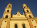
Cathedral in Culiacán

Culiacán's downtown

Culiacán street

Culiacán River by Sinaloa Blvd

"La Plazuela Rosales"

View north of Avenida Prol. Alvaro Obregon from Mirador La Lomita


See also[]
- Aguaruto, Sinaloa
- Culiacancito
- Las Flores, Culiacan
- Jardines Del Humaya
References[]
- ^ "Elevation of Culiacan,Mexico Elevation Map, Topography, Contour". www.floodmap.net.
- ^ "Sinaloa – Culiacán". September 3, 2007. Archived from the original on September 30, 2007. Retrieved July 3, 2020.
- ^ "Culiacán", Wikipedia, la enciclopedia libre (in Spanish), July 3, 2020, retrieved July 3, 2020
- ^ Escudo de Culiacán. "Escudo".
- ^ "Instituto Nacional de Estadística y Geografía (México)", Wikipedia, la enciclopedia libre (in Spanish), June 1, 2020, retrieved July 3, 2020
- ^ "México a Culiacán Rosales". México a Culiacán Rosales. Retrieved July 3, 2020.
- ^ "Sinaloa – Culiacán". October 1, 2013. Archived from the original on October 13, 2013. Retrieved July 3, 2020.
- ^ "NORMALES CLIMATOLÓGICAS 1951–2010" (in Spanish). Servicio Meteorológico Nacional. Archived from the original on March 3, 2016. Retrieved January 24, 2016.
- ^ "Extreme Temperatures and Precipitation for Culiacan (DGE) 1961–2011" (in Spanish). Servicio Meteorológico Nacional. Archived from the original on January 30, 2016. Retrieved January 24, 2016.
- ^ "NORMALES CLIMATOLÓGICAS 1981–2000" (PDF) (in Spanish). Servicio Meteorológico Nacional. Archived from the original (PDF) on January 30, 2016. Retrieved January 24, 2016.
- ^ "Klimatafel von Culiacán, Sinaloa / Mexiko" (PDF). Baseline climate means (1961–1990) from stations all over the world (in German). Deutscher Wetterdienst. Retrieved January 24, 2016.
- ^ Jump up to: a b "INEGI – México en cifras". April 20, 2011. Archived from the original on April 20, 2011. Retrieved September 10, 2020.
- ^ "Ficha Municipal" (PDF). November 22, 2012. Archived from the original (PDF) on November 22, 2012. Retrieved September 10, 2020.
- ^ SEDESOL. http://cat.microrregiones.gob.mx/catloc/contenido.aspx?clave=250060001&tbl=tbl01. Missing or empty
|title=(help) - ^ "Comisión Nacional de Pueblos Indígenas" (PDF).
- ^ De acuerdo a estimaciones del extinto INI a partir de la base de datos del XII Censo General de Población y Vivienda del INEGI 2000. Dimensión de la población hablante de lengua indígena de acuerdo con el número de hablantes, solo incluye personas de 5 años y más.
- ^ "Mexico's Sinaloa gang grows empire, defies crackdown". Reuters. January 19, 2011. Retrieved September 18, 2011.
- ^ Jump up to: a b "Officials: Wiretaps, aides led to drug lord arrest". Boston.com.
- ^ "Julio Cesar Chavez – Boxrec Boxing Encyclopaedia". Boxrec.com. July 1, 2012. Retrieved March 15, 2013.
- ^ Elie Seckbach %BloggerTitle% (June 1, 2010). "Julio Cesar Chavez Jr., Trainer Freddie Roach Workout". Boxing.fanhouse.com. Retrieved March 15, 2013.
- ^ "Omar Chavez – Boxrec Boxing Encyclopaedia". Boxrec.com. Retrieved March 15, 2013.
External links[]
| Wikimedia Commons has media related to Culiacán Rosales. |
 Culiacán travel guide from Wikivoyage
- (in Spanish) H. Ayuntamiento de Culiacán — Official website
- (in Spanish) Culiacán Travel Guide – Official website
| show |
|---|
| show Authority control |
|---|
- Culiacán
- Capitals of states of Mexico
- Cities in Mexico
- Populated places in Sinaloa
- Populated places established in 1531
- 1531 establishments in New Spain
- 1530s establishments in Mexico