Tangerhütte
Tangerhütte | |
|---|---|
 New Palace | |
 Coat of arms | |
show Location of Tangerhütte within Stendal district | |
 Tangerhütte | |
| Coordinates: 52°26′N 11°48′E / 52.433°N 11.800°ECoordinates: 52°26′N 11°48′E / 52.433°N 11.800°E | |
| Country | Germany |
| State | Saxony-Anhalt |
| District | Stendal |
| Subdivisions | 17 |
| Government | |
| • Mayor (2021–28) | Andreas Brohm[1] |
| Area | |
| • Total | 294.73 km2 (113.80 sq mi) |
| Elevation | 38 m (125 ft) |
| Population (2020-12-31)[2] | |
| • Total | 10,612 |
| • Density | 36/km2 (93/sq mi) |
| Time zone | UTC+01:00 (CET) |
| • Summer (DST) | UTC+02:00 (CEST) |
| Postal codes | 39511–39517 |
| Dialling codes | 03935 |
| Vehicle registration | SDL |
| Website | www.tangerhuette.de |


Tangerhütte (German: [taŋɐˈhʏtə] (![]() listen)) is a town in the district of Stendal, in Saxony-Anhalt, Germany. It has a population of 11,007 and is situated on the river Tanger, approximately 20 km south of Stendal.
listen)) is a town in the district of Stendal, in Saxony-Anhalt, Germany. It has a population of 11,007 and is situated on the river Tanger, approximately 20 km south of Stendal.
Geography[]
The town is situated near the river Tanger which the town was named after. Tangerhütte has access to the Magdeburg-Wittenberge railway.[3]

The Old Palace

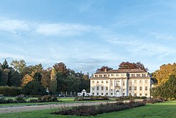
The New Palace
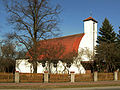
Church of Saint Elisabeth
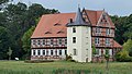
Briest Manor


History[]
In 1950, the municipality of Briest (Altmark) became part of Tangerhütte. The estate of Briest had been owned by the House of Bismarck since 1345.
References[]
- ^ Bürgermeisterwahlen in den Gemeinden, Endgültige Ergebnisse, Statistisches Landesamt Sachsen-Anhalt, accessed 8 July 2021.
- ^ "Bevölkerung der Gemeinden – Stand: 31. Dezember 2020" (PDF). Statistisches Landesamt Sachsen-Anhalt (in German). June 2021.
- ^ "DBRegio3Länderkarte 11_2016" (PDF). Bahn.de.
| show Authority control |
|---|
This Stendal district location article is a stub. You can help Wikipedia by . |
Categories:
- Towns in Saxony-Anhalt
- Stendal (district)
- Province of Saxony
- Bezirk Magdeburg
- Stendal district geography stubs