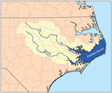
Tar River
This article needs additional citations for verification. (December 2013) |
| Tar River | |
|---|---|
 Tar River next to East Carolina University in Greenville, North Carolina | |
 | |
| Location | |
| Country | United States |
| State | North Carolina |
| Region | South |
| Cities | Louisburg, North Carolina, Rocky Mount, North Carolina, Tarboro, North Carolina, Greenville, North Carolina, Washington, North Carolina |
| Physical characteristics | |
| Source | a freshwater spring |
| • location | Person County, North Carolina, United States |
| • coordinates | 36°24′54″N 78°49′15″W / 36.41500°N 78.82083°W |
| • elevation | 715 ft (218 m) |
| Mouth | Pamlico Sound (as the Pamlico River) |
• location | Lowland, North Carolina, United States |
• coordinates | 35°20′08″N 76°28′20″W / 35.33556°N 76.47222°WCoordinates: 35°20′08″N 76°28′20″W / 35.33556°N 76.47222°W |
• elevation | −13 ft (−4.0 m) |
| Length | 346 km (215 mi) |
| Basin size | 15,920 km2 (6,150 sq mi) |

The Tar River is a river that is approximately 215 miles (346 km) long, in northeast North Carolina flowing generally southeast to an estuary of Pamlico Sound. The Tar River becomes the tidal Pamlico River once it underpasses the U.S. Highway 17 Bridge in Washington, North Carolina.
North Carolina was originally a naval stores colony—that is, the blanket of long leaf pines that covered the coastal plain was used by the British Navy for ships' masts and the pine pitch was used to manufacture tar caulking for vessels. The river derives its name from its historic use as a major route for tar-laden barges as they headed to the sea. The city of Tarboro is on the banks of the river. Recent research conducted by East Carolina University, Greenville and Pitt County historians has uncovered documentation noting that before the Civil War, the North Carolina Legislature had appropriated funds to construct dams and locks on the Tar River in an attempt to facilitate almost year-round navigation for the farm products and naval stores shipping plus passenger boats which were travelling between Tarboro, through Greenville to Washington.
Among the towns and cities along its course are Louisburg, Rocky Mount, Tarboro, and Greenville. The village of Old Sparta was formerly an important riverport on the Tar, but declined in the 20th century.
One account of the significance of the river's name comes from the Civil War.
It may have been inspired by an incident back in North Carolina. As the Confederates prepared to evacuate Washington, NC, in March 1862, they sent squads up and down the Tar River to destroy all the stocks of cotton and naval stores which had been prepared by the small farms along the river, to prevent them from falling into the hands of the Union soldiers. At Taft’s store they found over 1,000 barrels of turpentine and tar. The amount was too large to burn, as it would take several houses with it. So the barrels were rolled into the river, where the hoops were cut in two and the contents dumped into the river. Three months later, in June, four hundred Union prisoners of war were sent from Salisbury, NC to Washington, NC, to be exchanged for Confederate prisoners. Before coming into Washington, the soldiers asked permission to bathe in the river and clean themselves up. Guards were posted along the river banks, and the prisoners were allowed to strip then wade into the river to wash. Instead, they stirred up the river bottom so much that the tar smeared their bodies completely, each man coming out of the water with a stick to scour the tar off their bodies and legs. One Confederate yelled out, "Hello boys, what’s the matter?" The reply from the disgusted Yankee soldier was, "We have heard of Tar River all our lives but never believed that there really was any such place, but damned if we haven’t found it, the whole bed of it is tar!"[1]
The river was strongly affected by Hurricane Floyd in 1999 and caused much flooding in the area. The Tar River suffered the worst flooding from the hurricane, exceeding 500-year flood levels along its lower stretches; it crested 24 feet (7.3 m) above flood stage. When the river flooded in 1999, the height in Greenville was approximately 30 ft.
The river was again affected by Hurricane Matthew in 2016. It crested as much as 24.5 feet (7.5 m) above flood stage in some areas for up to 3 days.[2]
References[]
- ^ J. D. Meyers. "How the Yankees Found the Tar River." Carolina and the Southern Cross. Volume 1 (7), September 1913. Page 5.
- ^ "Hurricane Matthew Brings Record River Flooding to North Carolina – The Weather Channel".
External links[]
- Rivers of North Carolina
- Rivers of Beaufort County, North Carolina
- Rivers of Franklin County, North Carolina
- Rivers of Edgecombe County, North Carolina
- Rivers of Pitt County, North Carolina
- Tributaries of Pamlico Sound