Tauranga
Tauranga | |
|---|---|
City | |
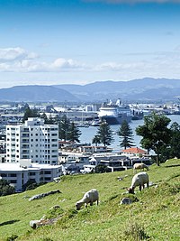 Tauranga from Mount Maunganui | |
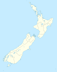 Tauranga Location of Tauranga, New Zealand | |
| Coordinates: 37°41′S 176°10′E / 37.683°S 176.167°ECoordinates: 37°41′S 176°10′E / 37.683°S 176.167°E | |
| Country | |
| Island | North Island |
| Region | Bay of Plenty |
| Territorial authority | Tauranga City Council |
| Wards | Mount Maunganui-Papamoa Otumoetai-Pyes Pa Te Papa-Welcome Bay |
| Settled | 1250–1300 |
| Gazetted as a borough | 1882 |
| City constituted | 17 April 1963 |
| Electorate(s) | Tauranga Bay of Plenty |
| Government | |
| • MP (Tauranga) | Simon Bridges (National) |
| • MP (Bay of Plenty) | Todd Muller (National) |
| • Mayor | Vacant |
| • Deputy Mayor | Tina Salisbury |
| Area | |
| • Territorial | 168 km2 (65 sq mi) |
| Highest elevation | 232 m (761 ft) |
| Lowest elevation | 0 m (0 ft) |
| Population (June 2020)[1] | |
| • Territorial | 151,300 |
| • Density | 900/km2 (2,300/sq mi) |
| • Urban | 151,300 |
| Time zone | UTC+12 (NZST) |
| • Summer (DST) | UTC+13 (NZDT) |
| Postcode(s) | 3110, 3112, 3116, 3118 |
| Area code(s) | 07 |
| Local iwi | Ngāti Ranginui, Ngāi Te Rangi, Ngāti Pūkenga |
| Website | Tauranga.govt.nz |


Tauranga (Māori pronunciation: [ˈtaʉɾaŋa])[2][3] is a coastal metropolitan city in the Bay of Plenty region and the fifth most populous city of New Zealand, with an urban population of 151,300 (June 2020)[1], or roughly 3% of the national population. It was settled by Māori late in the 13th century, colonised by Europeans in the early 19th century, and was constituted as a city in 1963.[4]
The city lies in the north-western corner of the Bay of Plenty, on the south-eastern edge of Tauranga Harbour. The city extends over an area of 168 square kilometres (65 sq mi), and encompasses the communities of Bethlehem, on the south-western outskirts of the city; Greerton, on the southern outskirts of the city; Matua, west of the central city overlooking Tauranga Harbour; Maungatapu; Mount Maunganui, located north of the central city across the harbour facing the Bay of Plenty; Otūmoetai; Papamoa, Tauranga's largest suburb, located on the Bay of Plenty; Tauranga City; Tauranga South; and Welcome Bay.
Tauranga is one of New Zealand's main centres for business, international trade, culture, fashion and horticultural science. The Port of Tauranga is New Zealand's largest port in terms of gross export tonnage and efficiency.[5] With its mild climate and favourable economic outlook,[according to whom?] Tauranga is one of New Zealand's fastest-growing cities, with an 11% increase in population between the 2006 census and the 2013 census,[6] and 19% between the 2013 and 2018 census. Due to its rapid population growth, Tauranga has become New Zealand's fifth-largest city, overtaking Dunedin and the Napier-Hastings urban areas.
History[]
Settlement[]
The earliest known settlers were Māori, who arrived in the 13th century at Tauranga in the Tākitimu and the Mātaatua waka.
At 9 am on Friday, 23 June 1826, Herald was the first European ship to enter Tauranga Harbour. The Revd. Henry Williams conducted a Christian service at Otamataha Pā.[7][8][9]
In December 1826 and again in March 1827, the Herald travelled to Tauranga from the Bay of Islands to obtain supplies of potatoes, pigs and flax.[10][11] In 1835 a Church Missionary Society mission station was established at Tauranga by William Wade. Rev. Alfred N. Brown arrived at the CMS mission station in 1838.[12] John Morgan also visited the mission in 1838.[13]

Europeans trading in flax were active in the Bay of Plenty during the 1830s; some were transient, others married local women and settled permanently. The first permanent non-Maori trader was James Farrow, who travelled to Tauranga in 1829, obtaining flax fibre for Australian merchants in exchange for muskets and gunpowder. Farrow acquired a land area of 2,000 square metres (1⁄2 acre) on 10 January 1838 at Otūmoetai Pā from the chiefs Tupaea, Tangimoana and Te Omanu, the earliest authenticated land purchase in the Bay of Plenty.[14]
In 1840, a Catholic mission station was established. Bishop Pompallier was given land within the palisades of Otūmoetai Pā for a church and a presbytery. The mission station closed in 1863 due to land wars in the Waikato district.[15]
New Zealand Wars–Tauranga Campaign[]
The Tauranga Campaign took place in and around Tauranga from 21 January to 21 June 1864, during the New Zealand Wars. The Battle of Gate Pa is the best known.
The Battle of Gate Pa[]
The Battle of Gate Pā was an attack on the well fortified Pā and its Māori defenders on 29 April 1864 by British forces made up of approximately 300 men of the 43rd Regiment and a naval contingent. The British casualties were 31 dead (including 10 officers), and 80 wounded - the single most devastating loss of life suffered by the British military in the whole of the New Zealand Wars. The Māori defenders abandoned the Pā during the night with casualties estimated at 25 dead and an unknown number of wounded.[16]
Tauranga today[]
Under the Local Government (Tauranga City Council) Order 2003,[17] Tauranga became legally a city for a second time, from 1 March 2004.
In August 2011, Tauranga received Ultra-Fast Broadband as part of the New Zealand Government's rollout.[18]
Suburbs[]
Here is a list of suburbs by electoral ward:
|
Te Papa / Welcome Bay: |
Otumoetai / Pyes Pa: |
Mount Maunganui / Papamoa: |
Others:
|
Geography[]
Tauranga is located around a large harbour that extends along the western Bay of Plenty, and is protected by Matakana Island and the extinct volcano of Mauao (Mount Maunganui). Ngamuwahine River is located 19 kilometres southwest of Tauranga.

Tauranga and the Bay of Plenty are situated along a faultline and so experience (infrequent) seismic activity. There are a few volcanoes around the area (mainly dormant). The most notable of these are White Island and Mauao, nicknamed "The Mount" by locals.
Tauranga is roughly the antipode of Jaén, Spain.
Climate[]
Tauranga has an oceanic or maritime temperate climate. It can also be described as subtropical.[19]
During the summer months the population swells as holidaymakers descend on the city, especially along the popular white coastal surf beaches from Mount Maunganui to Papamoa.
| hideClimate data for Tauranga (1981–2010) | |||||||||||||
|---|---|---|---|---|---|---|---|---|---|---|---|---|---|
| Month | Jan | Feb | Mar | Apr | May | Jun | Jul | Aug | Sep | Oct | Nov | Dec | Year |
| Average high °C (°F) | 24.0 (75.2) |
24.0 (75.2) |
22.5 (72.5) |
19.9 (67.8) |
17.4 (63.3) |
15.1 (59.2) |
14.5 (58.1) |
15.0 (59.0) |
16.6 (61.9) |
18.1 (64.6) |
20.1 (68.2) |
22.3 (72.1) |
19.1 (66.4) |
| Daily mean °C (°F) | 19.4 (66.9) |
19.6 (67.3) |
18.0 (64.4) |
15.5 (59.9) |
13.2 (55.8) |
10.8 (51.4) |
10.2 (50.4) |
10.7 (51.3) |
12.3 (54.1) |
13.9 (57.0) |
15.8 (60.4) |
18.0 (64.4) |
14.8 (58.6) |
| Average low °C (°F) | 14.8 (58.6) |
15.3 (59.5) |
13.5 (56.3) |
11.0 (51.8) |
9.0 (48.2) |
6.6 (43.9) |
5.9 (42.6) |
6.4 (43.5) |
8.0 (46.4) |
9.7 (49.5) |
11.4 (52.5) |
13.6 (56.5) |
10.4 (50.7) |
| Average precipitation mm (inches) | 76.0 (2.99) |
86.6 (3.41) |
92.7 (3.65) |
120.9 (4.76) |
105.7 (4.16) |
115.7 (4.56) |
127.4 (5.02) |
112.3 (4.42) |
87.6 (3.45) |
90.4 (3.56) |
75.3 (2.96) |
90.3 (3.56) |
1,180.9 (46.49) |
| Average precipitation days (≥ 1.0 mm) | 6.4 | 7.0 | 8.0 | 8.4 | 8.6 | 10.9 | 11.5 | 11.8 | 10.4 | 10.3 | 9.1 | 8.2 | 110.4 |
| Average relative humidity (%) | 74.4 | 77.7 | 77.7 | 80.4 | 83.3 | 85.5 | 84.1 | 81.9 | 77.4 | 75.2 | 73.4 | 74.8 | 78.8 |
| Mean monthly sunshine hours | 261.5 | 217.3 | 214.0 | 183.9 | 165.3 | 135.4 | 151.0 | 173.4 | 174.1 | 212.7 | 224.2 | 232.7 | 2,345.6 |
| Source: NIWA Climate Data[20] | |||||||||||||
Demographics[]
In 1976 Tauranga was a medium-sized urban area with a population of around 48,000. However, the completion of a harbour bridge in 1988 brought Tauranga and The Mount closer (they amalgamated in 1989) and re-energised the economies of both parts of the enlarged city. By 1996 Tauranga's population had grown to 82,092 and by 2006 it had reached 103,635.[21]
In 2008 Tauranga overtook Dunedin to become the sixth-largest city in New Zealand by urban area, and the ninth largest city by Territorial Authority area.
| Year | Pop. | ±% p.a. |
|---|---|---|
| 2006 | 103,881 | — |
| 2013 | 114,789 | +1.44% |
| 2018 | 136,713 | +3.56% |
| Source: [22] | ||
Tauranga's rapid growth has continued unabated, and by the time of the 2018 New Zealand census its population had reached 136,713, a dramatic increase of 21,924 people (19.1%) since the previous 2013 census only five years earlier. With continuing growth it has now surpassed the Napier-Hastings area to become New Zealand's fifth-largest city.
In 2018 there were 50,442 households. There were 65,868 males and 70,845 females, giving a sex ratio of 0.93 males per female. Of the total population, 27,564 people (20.2%) were aged up to 15 years, 23,235 (17.0%) were 15 to 29, 58,938 (43.1%) were 30 to 64, and 26,979 (19.7%) were 65 or older. Figures may not add up to the total due to rounding.
Ethnicities were 81.7% European/Pākehā, 18.2% Māori, 2.9% Pacific peoples, 7.6% Asian, and 2.1% other ethnicities. People may identify with more than one ethnicity.
The percentage of people born overseas was 21.7, compared with 27.1% nationally.
Although some people objected to giving their religion, 50.8% had no religion, 35.5% were Christian, and 7.1% had other religions.
Of those at least 15 years old, 21,570 (19.8%) people had a bachelor or higher degree, and 18,957 (17.4%) people had no formal qualifications. The median income was $31,600. The employment status of those at least 15 was that 51,591 (47.3%) people were employed full-time, 16,233 (14.9%) were part-time, and 3,753 (3.4%) were unemployed.[22]
The city hosts five major head offices – Port of Tauranga, Zespri International, Ballance Agri-Nutrients Ltd, Trustpower and Craigs Investment Partners (formerly, ABN AMRO Craigs).

Government and politics[]
Tauranga is located in the administrative area of the Tauranga City Council. The council consists of ten councillors and a mayor. Four councillors are elected by the city at large; the remainder are elected from three wards (constituencies), with each ward electing two councillors:
- Te Papa / Welcome Bay
- Otūmoetai / Pyes Pa
- Mount Maunganui / Papamoa
Council elections are held every three years, most recently in 2019. In December 2020, the Minister of Local Government Nanaia Mahuta announced that, due to dysfunction within the elected council, the council would be replaced by commissioners until the 2022 local elections.[23][24]
For elections to the New Zealand Parliament, the city of Tauranga is in the Tauranga and Bay of Plenty electorates.
Economy[]
Much of the countryside surrounding Tauranga is horticultural land, used to grow a wide range of fresh produce for both domestic consumption and export. There are many kiwifruit and avocados orchards as well as other crops.
The Port of Tauranga is New Zealand's largest export port. It is a regular stop for both container ships and luxury cruise liners.


Tauranga's main shopping mall is Bayfair, in Mount Maunganui. Most of the city's shopping centres are located in the suburbs. They include Fraser Cove, Tauranga Crossing, Bethlehem Town Centre, Palm Beach Plaza, Fashion Island, Bayfair Shopping Centre, Bay Central and Greerton Village.
Tauranga has the following business innovation centres
The following companies have their head office in Tauranga:
- Ballance Agri-Nutrients[27]
- Brother NZ
- C3 Limited[28]
- Craigs Investment Partners Ltd[29]
- Dominion Salt[30]
- Genera Biosecurity
- Kiwi Bus Builders
- Port of Tauranga
- Shuzi New Zealand Limited[31]
- Tidy International [26]
- Trimax Mowing Systems
- TrustPower
- UNO. Magazine
- Zespri International
Arts and culture[]
Religion[]
A wide variety of faiths are practised, including Christianity, Hinduism, Buddhism, Islam, Sikhism, Taoism and Judaism. There are many denominations of Christianity including Pentecostal, Methodist, Presbyterian, Roman Catholic, Exclusive Brethren, Baptist and The Church of Jesus Christ of Latter-day Saints (LDS Church).
Music[]
The National Jazz Festival takes place in Tauranga every Easter.[32]
Events[]
New Year celebrations at the Mount in Mount Maunganui are one of Tauranga's main events, bringing people from all around the country.
In 2014 Tauranga City Council granted permission for an annual Sikh parade to celebrate Guru Gobind Singh's birthday. 2500 people took part in 2014, while in 2015, the number increased to 3500.[33]
Sports[]

Tauranga has a large stadium complex in the Bayfair suburb, Baypark Stadium, rebuilt in 2001 after a similar complex closed in 1995. It hosts Speedway events during summer and rugby matches in winter.
Tauranga is also the home of football (soccer) club Tauranga City United who compete in the Lotto Sport Italia NRFL Division 2.
Tauranga is the home to two rowing clubs – Tauranga Rowing Club in Memorial Park and Bay of Plenty Coast Rowing Club at the picturesque Wairoa River. Both clubs have had successful NZ representation over the years.
Tauranga has an all weather outdoor athletics ground at Tauranga Domain.
City facilities and attractions[]
Greater Tauranga is a very popular lifestyle and tourism destination. It features many natural attractions and scenery ranging from popular beaches and harbour environments to lush bush-clad mountains with waterfalls and lakes.

Cultural attractions include the Tauranga Art Gallery, which opened in October 2007 and showcases local, national and international exhibitions in a range of media. On the 17th Avenue, the "Historic Village on 17th",[34] recreates a historic setting with original and replica buildings from early Tauranga housing arts and gift shops.
Aviation interests are well served with the Classic Flyers Museum and the Gyrate Flying Club where you can experience flying a modern gyroplane; the "motorbike of the sky".[35]
Tauranga has many parks: one of the largest is Memorial Park, and others include, Yatton Park, Kulim Park, Fergusson Park and the large Tauranga Domain. The has become a regional attraction, known for being converted from a disused quarry into a community park.[36]
Due to the temperate climate, outdoor activities are very popular, including golf, tramping (hiking), mountain biking and white water rafting. The Bay of Plenty coastline has miles of golden sandy beaches, and watersports are very popular, including swimming, surfing, fishing, diving, kayaking and kitesurfing. Tourists also enjoy dolphin-watching on specially run boat trips.
The coastal suburb Papamoa and neighbouring town Mount Maunganui are some of the more affluent areas around Tauranga. The region's beaches attract swimmers, surfers, kayakers and kitesurfers throughout the year.
Tauranga has many outlying islands and reefs that make it a notable tourist destination point for travelling scuba divers and marine enthusiasts.[37] Extensive marine life diversity is available to scuba divers all year round. Water temperatures range from 12 degrees Celsius in winter to 22–24 degrees Celsius in summer. Tauranga houses two professional dive instructor training centres, training NAUI, PADI and SSI dive leader systems.
Infrastructure[]
Hospitals[]
Tauranga Hospital is a public secondary regional hospital located in Tauranga South, with 349 beds including neonatal, maternity and mental health care.[38] It provides elective and emergency healthcare across medical, surgical, paediatric, obstetric, gynaecological and psychiatric services. The main tertiary referral centre for Tauranga Hospital is Waikato Hospital, located in Hamilton. As the site of the Bay of Plenty Clinical School, Tauranga Hospital provides training to medical students from the University of Auckland, as well as selective and elective placements for nursing and midwifery students.[39]
Grace Hospital is Tauranga's only private specialist surgical hospital, located in Oropi.
Utilities[]
Powerco operates the local distribution network in the city,[40] with electricity supplied from Transpower's national grid at three substations: Tauranga (Greerton), Kaitemako and Mount Maunganui (Matapihi).
Natural gas arrived in Tauranga in 1982, following the completion of the high-pressure pipeline from the Maui pipeline near Te Awamutu to the city, now operated by First Gas.[41] First Gas also operates the gas distribution network within the city.
Transport[]
Tauranga City Council is currently responsible for approximately 530 km of roads, 700 km of footpaths, cycle ways and access ways.[42]
Tauranga City Council also has a bit of work under way with their Transportation and Roads strategy. Their aim for the future to change current travel behaviour from a focus on private cars to more sustainable modes such as buses, cycling and walking.
Air[]
Tauranga Airport is served by several airlines offering flights to Auckland, Wellington and Christchurch as well as some regional destinations within New Zealand. Sunair is based in Tauranga, operating a fleet of light aircraft. Sunair operates from Tauranga Airport to Gisborne, Claris, Whitanga, Motiti Island and North Shore. In addition Barrier Air operates from Tauranga to Claris with a Partenavia P68.
Rail[]

Tauranga is located on the East Coast Main Trunk Railway.
Bus[]
Main transportation in the city is provided by the BayBus, with twelve routes servicing the city's population. Bay Hopper buses depart the central stops in Tauranga's CBD, Ohauiti, Mount Maunganui and Bayfair every 15 minutes, with the routes to Papamoa and Greerton half-hourly.[43] Bee cards were introduced for fares on 27 July 2020.[44]
The city is also a waypoint for bus travel between cities, with the Bay Hopper, and Intercity having a daily schedule.
Education[]
Tauranga is home to the Bay of Plenty Tertiary Education Partnership, made up of:
- Toi Ohomai Institute of Technology, Te Whare Wānanga o Awanuiārangi
- The University of Waikato
- Te Whare Wānanga o Awanuiārangi[45]
The organisations currently share two main campuses, but are planning a new central campus. Stage 1 is expected to be open in 2017, catering for 500 but with capacity for 700, which will cost $67.3 Million.[46][47]
Tauranga's secondary schools are:
- Tauranga Boys' College, with about 1850 boys.
- Tauranga Girls' College, with over 1500 girls.
- Otumoetai College, with around 1900 students.
- Bethlehem College, a state integrated Christian school offering kindergarten and Year 1–13, with around 1500 students.
- Aquinas College a state integrated coeducational Catholic school founded in 2003 for Years 7–13, with around 800 students.
- Mount Maunganui College, a co-educational secondary school, with over 1500 students.
- Papamoa College, co-educational secondary school opened in 2011 for years 7 – 13.
- Te Wharekura o Mauao,[48] a co-educational wharekura-ā-iwi for Years 7–13, founded in 2010, with around 200 students.
- Te Kura Kaupapa Māori o Te Kura Kōkiri, a co-educational kura kaupapa Māori total immersion school for Years 1–13, founded in 2000, with around 140 students.
ACG Tauranga, the city's first fully private school,[49][50] offers pre-school to Year 12.[51]
There is also a Rudolf Steiner School in Welcome Bay, catering for birth to 12-year-olds.
Notable residents[]
- Corey Anderson – international cricketer
- Trent Boult – international cricketer
- Tyler Boyd – footballer
- Peter Burling – America's Cup helmsman and Olympic medallist
- Sam Cane – international rugby player
- Bob Clarkson – former Member of Parliament and property developer
- Dame Lynley Dodd – award-winning author and illustrator, principally known for her children's picture books featuring Hairy Maclary and his friends
- Mahé Drysdale – Olympic rower
- Tim Balme – actor, director
- John Bracewell – international cricketer
- Simon Bridges – politician; Former Leader of the New Zealand National Party
- Moss Burmester – Olympic swimmer
- Tony Christiansen – former Paralympics, FESPIC Games and World Games medallist, professional speaker and Tauranga City Councillor
- Dame Susan Devoy – former World Squash Champion
- Daniel Flynn – international cricketer
- Hilda Hewlett – pioneer aviator
- Gunnar Jackson – professional middleweight boxer
- Jess Johnson – artist
- Tanerau Latimer – former international rugby player
- Tony Lochhead – footballer
- Richard O'Brien – author of The Rocky Horror Show (spent his formative years here)
- Phil Rudd – drummer for AC/DC
- Andrew Stevenson – Olympic rower, Double World Champion Rower, NZ 1982 Sportsman of the Year
- Sir Gordon Tietjens – Coach of the New Zealand national rugby sevens team
- Kane Williamson – international cricketer
Past residents[]
- Kathleen Hawkins – known as the "Pioneer Poet"
- Les Munro – Dambusters veteran
- Winston Peters – former MP for Tauranga, leader of NZ First, politician
- Stan Walker – R&B singer, Former Australian Idol contestant and winner[52]
Sister cities[]
Tauranga is twinned with:[53]
 Hitachi, Japan
 San Bernardino, United States
 Yantai, China
References[]
- ^ Jump up to: a b "Population estimate tables - NZ.Stat". Statistics New Zealand. Retrieved 22 October 2020.
- ^ "100 Māori words every New Zealander should know – Māori Language Week | NZHistory, New Zealand history online". Nzhistory.net.nz. 1 August 1987. Archived from the original on 1 August 2012. Retrieved 20 September 2015.
- ^ "Tauranga pronunciation: How to pronounce Tauranga in Māori, English". Forvo.com. 12 April 2008. Archived from the original on 11 September 2015. Retrieved 20 September 2015.
- ^ "Local Government 1860 – present". Tauranga City Council. Archived from the original on 14 October 2008. Retrieved 19 December 2008.
- ^ "Port of Tauranga Limited – New Zealand's largest and most efficient port – Port of Tauranga". Port-tauranga.co.nz. Archived from the original on 15 September 2015. Retrieved 20 September 2015.
- ^ "Auckland drives 5% population growth | Radio New Zealand News". Radionz.co.nz. 15 October 2013. Archived from the original on 24 September 2015. Retrieved 20 September 2015.
- ^ "Appendix IV – The Herald (W. Williams, Journal, 20 June 1826)". Williams, H. The Early Journals of Henry Williams, p. 479-494. 1961. Archived from the original on 2 February 2018. Retrieved 14 February 2017.
- ^ Fitzgerald, Caroline (2011). Te Wiremu: Henry Williams – Early Years in the North. Huia Publishers, New Zealand. pp. 72–73. ISBN 978-1-86969-439-5.
- ^ "Koraurau (?-1828)". Tauranga Memories : Tauranga Local History. Archived from the original on 16 February 2017. Retrieved 14 February 2017.
- ^ Williams, H. (1961). "Appendix IV – The Herald (W. Williams, Journal, 28 November 1826; H. Williams to C. M. S., 13 December 1826)". The Early Journals of Henry Williams. pp. 479–494. Archived from the original on 2 February 2018. Retrieved 14 February 2017.
- ^ "Appendix IV – The Herald (H. Williams, Journal, 26 March 1827; 7 April 1827)". Williams, H. The Early Journals of Henry Williams, p. 479-494. 1961. Archived from the original on 2 February 2018. Retrieved 14 February 2017.
- ^ Rogers, Lawrence M. (1973). Te Wiremu: A Biography of Henry Williams. Pegasus Press.
- ^ Morgan, John. "The Church Missionary Gleaner, December 1841". Horrors Attending New Zealand Warfare. Adam Matthew Digital. Retrieved 9 October 2015.
- ^ "The Traders". Archived from the original on 20 October 2008. Retrieved 18 June 2009.
- ^ "Area Guide Tauranga – Introduction to the Bay of Plenty". Kiwitourism.com. 18 June 2006. Archived from the original on 22 January 2016. Retrieved 20 September 2015.
- ^ Cowan, James (1922). "42, Gate Pa and Te Ranga". The New Zealand Wars: A History of the Maori Campaigns and the Pioneering Period, Vol. 1, 1845–1864. Wellington: RNZ Government Printer.
- ^ [1] Archived 27 October 2005 at the Wayback Machine
- ^ "Ultra fast broadband comes to Tauranga". Voxy.co.nz. 23 August 2011. Archived from the original on 10 June 2015. Retrieved 20 September 2015.
- ^ "Northern New Zealand". NIWA. 28 February 2007. Archived from the original on 2 March 2012. Retrieved 14 May 2014.
- ^ "Climate Data and Activities". NIWA Science. 28 February 2007. Archived from the original on 10 October 2013. Retrieved 15 October 2013.
- ^ Geonames Database "Region information page", travelsradiate, 2010, accessed 2 January 2011.
- ^ Jump up to: a b "Statistical area 1 dataset for 2018 Census". Statistics New Zealand. March 2020. Tauranga City (023). 2018 Census place summary: Tauranga City
- ^ "Tauranga City Council to be replaced by commissioner". Stuff. 4 December 2020. Retrieved 21 December 2020.
- ^ "Commissioner for Tauranga as councillors' pleas to stay in charge prove futile". Stuff. 18 December 2020. Retrieved 21 December 2020.
- ^ Motion, Samantha (10 October 2018). "First glimpse at Tauranga's The Kollective, new $10m building in the Historic Village". Bay of Plenty Times.
- ^ Jump up to: a b Hall, Carmen (9 August 2020). "Tauranga global exporters spark multimillion-dollar development at business park". Bay of Plenty Times.
- ^ "Home". Ballance.co.nz. Archived from the original on 1 October 2015. Retrieved 20 September 2015.
- ^ "New Zealand's leading provider of product handling solutions, on the wharf and beyond". C3. Archived from the original on 29 July 2015. Retrieved 20 September 2015.
- ^ "One of New Zealand's largest investment advisory and management firms". Craigsip.com. Archived from the original on 20 February 2016. Retrieved 22 February 2016.
- ^ "Leading Salt Manufacturer NZ". Dominion Salt. 20 June 2014. Archived from the original on 20 September 2015. Retrieved 20 September 2015.
- ^ "Shuzi New Zealand – Shuzi New Zealand". Shuziqi.co.nz. Archived from the original on 25 August 2015. Retrieved 20 September 2015.
- ^ "National Jazz Festival 2015 – Home". Jazz.org.nz. Archived from the original on 10 September 2015. Retrieved 21 September 2015.
- ^ Keber, Ruth (5 January 2015). "Showcase of culture and colour in annual Sikh parade". The New Zealand Herald. Archived from the original on 5 January 2015. Retrieved 5 January 2015.
- ^ "Historic Village on 17th". Tourism Bay of Plenty. Archived from the original on 15 December 2014. Retrieved 1 September 2014.
- ^ "Gyrate New Zealand | Fly a Gyro! | Flight Training & Sales". Gyrate.co.nz. Archived from the original on 1 October 2015. Retrieved 21 September 2015.
- ^ "Walking Tracks, Gardens, Sculptures | Te Puna Quarry Park". Quarrypark.org.nz. Archived from the original on 15 September 2015. Retrieved 21 September 2015.
- ^ "The best of Tauranga walking tour". Stuff.co.nz. 2021. Retrieved 21 January 2021.
- ^ "Tauranga Hospital". Bay of Plenty District Health Board. Retrieved 30 March 2020.
- ^ "Clinical School". Bay of Plenty District Health Board. Retrieved 30 March 2020.
- ^ "Our Networks". Powerco. Archived from the original on 15 October 2018. Retrieved 15 October 2018.
- ^ "The New Zealand Gas Story". Gas Industry Company. December 2016. Archived from the original on 2 February 2017. Retrieved 31 October 2018.
- ^ "Roads & Road Works". www.tauranga.govt.nz. 24 March 2014. Archived from the original on 25 March 2014. Retrieved 3 April 2014.
- ^ "Baybus: Relax, Take a Bus in the Bay of Plenty". www.baybus.co.nz. Retrieved 21 August 2020.
- ^ "Bee Card". www.baybus.co.nz. Retrieved 21 August 2020.
- ^ "Tertiary providers renew commitment to Bay's Education Partnership". The University of Waikato. Archived from the original on 4 September 2018. Retrieved 4 September 2018.
- ^ "Tauranga to have CBD uni campus – The Bay's News First". SunLive. 26 January 2012. Archived from the original on 24 September 2015. Retrieved 21 September 2015.
- ^ "Opinion: CBD transformation a major boost for Tauranga". Bay of Plenty Times. 10 July 2018. Archived from the original on 4 September 2018. Retrieved 4 September 2018.
- ^ Diamond, Amy (10 April 2018). "School of the Week: Te Wharekura o Mauao has continued to grow since it opened". Bay of Plenty Times. Archived from the original on 4 September 2018. Retrieved 4 September 2018.
- ^ ACG Tauranga Term Dates, archived from the original on 2 May 2014, retrieved 1 May 2014
- ^ Press Release: Academic Colleges Group (15 August 2013), "NZ independent school group, ACG, looks to open in Tauranga", Scoop Education, archived from the original on 2 May 2014, retrieved 1 May 2014
- ^ Hunter, Zoe (12 December 2018). "School of the Week: ACG Tauranga". Bay of Plenty Times. Archived from the original on 4 September 2018. Retrieved 4 September 2018.
- ^ "Kiwi leads Idol show by a neck". The Dominion Post. 10 September 2009. Archived from the original on 23 October 2012. Retrieved 3 November 2009.
- ^ "Community Partnerships" (PDF). tauranga.govt.nz. Tauranga City Council. Retrieved 20 May 2020.
External links[]
| Wikimedia Commons has media related to Tauranga. |
| Wikivoyage has a travel guide for Tauranga. |
| show Authority control |
|---|
- Tauranga
- Main urban areas in New Zealand
- Territorial authorities of New Zealand
- Port cities in New Zealand