Teresópolis
Coordinates: 22°24′43″S 42°57′57″W / 22.41194°S 42.96583°W

Teresópolis
Município de Teresópolis | |
|---|---|
 Top left:Dedo de Deus in Serra dos Órgãos National Park, Top right:A view of Feirinha do Alto area, Second left:Matriz de Santa Teresa church in Baltasar Square, Second right:Agrioes downtown area,Third left:Lago Comary (Comary Lake),Third right:Cachoeira dos Friars Natural Park, Bottom:A view of Carlos Guinle area | |
 Flag  Seal | |
| Nickname(s): Terê | |
| Motto(s): "Sub Digitum Dei" (Latin for, "Under God's Finger") | |
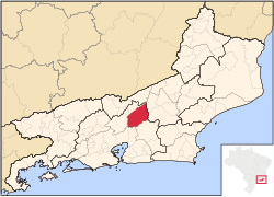 Location of Teresópolis in the state of Rio de Janeiro | |
| Coordinates: 22°24′43″S 42°57′57″W / 22.41194°S 42.96583°W | |
| Country | Brazil |
| Region | Southeast |
| State | Rio de Janeiro |
| Founded | 1891 |
| Government | |
| • Mayor | Vinicius Claussen |
| Area | |
| • Total | 773.338 km2 (298.587 sq mi) |
| Elevation | 871 m (2,858 ft) |
| Population (2020 [2]) | |
| • Total | 184,240 |
| • Density | 240/km2 (620/sq mi) |
| Time zone | UTC-3 (UTC-3) |
| Website | teresopolis.rj.gov.br |

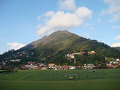
Teresópolis (Portuguese pronunciation: [teɾeˈzɔpolis], [tɛɾeˈzɔpɔliɕ], [tɛɾeˈzɔpuliɕ], [teɾeˈzɔpuliɕ]) is a Brazilian municipality located in the state of Rio de Janeiro, in a mountainous region known as Região Serrana. The Serra dos Órgãos National Park lies partly within the city limits. The city is known as the home of the Brazil national football team, since it hosts CBF's training ground at Granja Comary.[3]
History[]

Before the arrival of the Portuguese to the area where Teresópolis lies today, in the 16th century, it was inhabited by indigenous Brazilians. In the following centuries, Portuguese started buying land there. The region was also occupied by a quilombo, formed by runaway slaves coming from sugar cane plantations near Rio de Janeiro.
In 1821, English citizen George March (born and raised in Portugal) established a farm there, which later became the most important settlement along the way between the court, in Rio de Janeiro, and the territory of Gerais (nowadays, the state of Minas Gerais), which led to the great improvement of agriculture and cattle raising.
The Brazilian imperial family was much impressed by the natural beauty and the climate of the region, which developed slowly so that in 1855 the settlement became a village that was named Freguesia de Santo Antonio de Paquequer.
The further development of the village was due to the traders that came from Minas Gerais in the way to Rio de Janeiro, and used the region as a resting stop. Finally, on July 6, 1891, the village became a municipality that was named Teresópolis ("city of Teresa"), after Empress Teresa Cristina, wife of Emperor Pedro II.
Geography[]
According to the 2010 Brazilian Census, the city has a population of 163,746 within a land area of 770,6 km2. The Serra dos Órgãos National Park is in the vicinity. Its predominant vegetation belongs to the Atlantic Forest type. The city is surrounded by forests and by well-known summits or peaks, because of which the city is known as the national capital of mountaineering. The most famous peaks are:
- Peak of Pedra do Sino – 2,263 metres (7,425 ft)
- Peak of Pedra do Açu – 2,230 metres (7,320 ft)
- Peak of Agulha do Diabo – 2,020 metres (6,630 ft)
- Peak of Nariz do Frade – 1,919 metres (6,296 ft)
- Peak of Dedo de Deus – 1,651 metres (5,417 ft)
- Peak of Pedra da Ermitage – 1,485 metres (4,872 ft)
- Peak of Dedo de Nossa Senhora – 1,320 metres (4,330 ft)
Of these, Dedo de Deus ("God's finger") is the most famous.
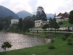
The municipality contains the 4,397 hectares (10,870 acres) Montanhas de Teresópolis Municipal Nature Park, created in 2009 to protect a large area of Atlantic Forest.[4] The municipality contained the 2,700 hectares (6,700 acres) Floresta do Jacarandá Environmental Protection Area, but this was extinguished in 2013.[5][6] It contains the 7,500 hectares (19,000 acres) Bacia dos Frades Environmental Protection Area, created in 1990.[7] The municipality contains 20% of the 46,350 hectares (114,500 acres) Três Picos State Park, created in 2002.[8] It contains part of the Central Rio de Janeiro Atlantic Forest Mosaic of conservation units, created in 2006.[9]
Climate[]
Teresópolis features a subtropical highland climate (Köppen climate classification: Cfb), with relatively cold and dry winters and mild and wet summers. The annual average temperature is 16 °C/60.8 °F.
Teresópolis has one of the mildest climates in Brazil[10] and this is one reason why the area has been chosen as Brazilian Football Confederation's training headquarters, hosting the Brazil national football team, located in Granja Comary.
| hideClimate data for Teresópolis (1961–1990) | |||||||||||||
|---|---|---|---|---|---|---|---|---|---|---|---|---|---|
| Month | Jan | Feb | Mar | Apr | May | Jun | Jul | Aug | Sep | Oct | Nov | Dec | Year |
| Average high °C (°F) | 26.6 (79.9) |
26.8 (80.2) |
26.2 (79.2) |
23.3 (73.9) |
21.7 (71.1) |
21.1 (70.0) |
20.6 (69.1) |
22.2 (72.0) |
22.6 (72.7) |
22.7 (72.9) |
23.5 (74.3) |
25.1 (77.2) |
23.5 (74.3) |
| Daily mean °C (°F) | 20.7 (69.3) |
20.8 (69.4) |
20.2 (68.4) |
17.9 (64.2) |
15.8 (60.4) |
14.9 (58.8) |
14.3 (57.7) |
15.6 (60.1) |
16.7 (62.1) |
17.5 (63.5) |
18.3 (64.9) |
19.7 (67.5) |
17.7 (63.9) |
| Average low °C (°F) | 16.2 (61.2) |
16.3 (61.3) |
15.6 (60.1) |
13.6 (56.5) |
11.4 (52.5) |
10.5 (50.9) |
9.7 (49.5) |
10.9 (51.6) |
12.2 (54.0) |
13.4 (56.1) |
14.2 (57.6) |
15.4 (59.7) |
13.3 (55.9) |
| Average precipitation mm (inches) | 401.9 (15.82) |
322.6 (12.70) |
263.3 (10.37) |
226.3 (8.91) |
120.7 (4.75) |
69.8 (2.75) |
83.4 (3.28) |
101.3 (3.99) |
143.7 (5.66) |
264.5 (10.41) |
351.5 (13.84) |
425.4 (16.75) |
2,774.3 (109.22) |
| Average precipitation days (≥ 1.0 mm) | 19 | 15 | 14 | 13 | 9 | 7 | 7 | 8 | 10 | 17 | 18 | 19 | 156 |
| Average relative humidity (%) | 86.6 | 85.9 | 86.6 | 88.7 | 87.4 | 86.3 | 85.4 | 83.5 | 84.4 | 87.7 | 88.4 | 87.2 | 86.5 |
| Mean monthly sunshine hours | 159.7 | 152.6 | 162.9 | 151.1 | 163.7 | 158.9 | 169.4 | 180.4 | 144.5 | 117.0 | 118.2 | 137.8 | 1,816.2 |
| Source: Instituto Nacional de Meteorologia[11][12] | |||||||||||||
Tragedy[]
The uncontrolled growth of Teresópolis and other cities of the mountainous region near Rio de Janeiro led to the construction of a great number of houses in mountainous terrain or on the banks of rivers. This fact, together with a 24-hour rainfall that exceeded what was expected for the entire month, caused a series of floods and mudslides in January 2011. More than 400 people died and thousands lost their houses in the event, which is considered the worst weather-related tragedy in Brazilian history. .[13][14]
Gallery[]
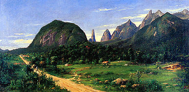
Teresópolis in 1885

Partial view of the municipality

Torres de Bonsucesso

Teresópolis during the January 2011 Rio de Janeiro floods and mudslides, which killed 382 people in the municipality and at least 610 altogether

God's Finger

Devil's Needle
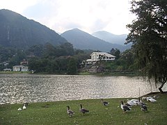
Lake Comary
Granja Comary, The Brazilian Football Confederation's training ground
Lake houses
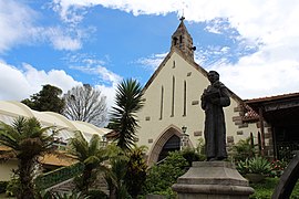
Santo Antônio Church. It is dedicated to Saint Anthony of Padua

Black swan on Lake Comary

Higino Hotel
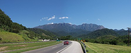
Rio-Teresópolis highway (stretch of BR-116) connecting Greater Rio de Janeiro to Teresópolis

Empress Teresa Cristina statue at the entrance of the municipality. Teresópolis was named in her honor.

A farm in the rural area of Teresópolis


Sister cities[]
Teres��polis' sister cities are:
References[]
- ^ "Brazilian Institute of Geography and Statistics" (in Portuguese). 2017. Retrieved 27 March 2019.
2018 Area Total
- ^ IBGE 2020
- ^ http://www.teresopolison.com/cbf.php
- ^ Parque Natural Municipal Montanhas de Teresópolis (in Portuguese), Prefeitura Municipal de Teresópolis: Secretaria de Meio Ambiente, retrieved 2016-10-04
- ^ APA Floresta do Jacarandá (in Portuguese), ISA: Instituto Socioambiental, retrieved 2016-10-03
- ^ Parque Estadual dos Três Picos (in Portuguese), INEA: Instituto Estadual do Ambiente, retrieved 2016-10-03
- ^ APA da Bacia dos Frades (in Portuguese), INEA: Instituto Estadual do Ambiente, retrieved 2016-10-03
- ^ PES dos Três Picos (in Portuguese), ISA: Instituto Socioambiental, retrieved 2016-10-03
- ^ Costa, Cláudia; Lamas, Ivana; Fernandes, Rosan (December 2010), Planejamento Estratégico do Mosaico Central Fluminense (PDF) (in Portuguese), Reserva da Biosfera da Mata Atlântica, p. 13, retrieved 2016-10-02
- ^ "Os encantos de Teresópolis". Geórgia Honório. 365 dias viajando. 14 April 2009. Retrieved 5 November 2011.
- ^ "Gráficos Climatológicos (1931-1960 e 1961-1990)" (in Portuguese). Instituto Nacional de Meteorologia. Archived from the original on 15 November 2018. Retrieved 31 August 2019.
- ^ "Normais Climatológicas Do Brasil 1961–1990" (in Portuguese). Instituto Nacional de Meteorologia. Retrieved 31 August 2019.
- ^ Stuart Grudgings (January 12, 2011). "UPDATE 5-At least 257 died as rains pummeled this Brazilian region". Reuters. Retrieved January 13, 2011.
- ^ Tom Phillips (January 14, 2011). "Brazil Landslides Death Toll Rises". The Guardian. Retrieved January 14, 2011.
External links[]
| Wikimedia Commons has media related to Teresópolis. |
| Wikivoyage has a travel guide for Teresópolis. |
Official[]
- City Hall (Prefeitura Municipal) (in Portuguese)
- Municipal Legislative Chamber (Câmara Municipal) (in Portuguese)
Tourism[]
- Visite Teresópolis - Tourism, Information, news, photos... (in Portuguese)
- Teresopolis.com.br - Complete guide to the city, Information, news, and photos (in Portuguese)
- TeresopolisOn - Information, news, and photos (in Portuguese)
- Portal Terê - Complete guide to the city (in Portuguese)
| show |
|---|

| Authority control |
|
|---|
- Teresópolis
- 1891 establishments in Brazil
- Populated places established in 1891