Cabo Frio
Cabo Frio | |
|---|---|
Municipality | |
| Município de Cabo Frio | |
 | |
 Flag  Seal | |
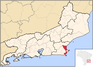 Location of Cabo Frio in the state of Rio de Janeiro | |
 Cabo Frio Location of Cabo Frio in Brazil | |
| Coordinates: 22°52′44″S 42°01′08″W / 22.87889°S 42.01889°WCoordinates: 22°52′44″S 42°01′08″W / 22.87889°S 42.01889°W | |
| Country | |
| Region | Southeast |
| State | |
| Government | |
| • Mayor | José Bonifácio Ferreira Novellino (PDT) |
| Area | |
| • Total | 410.418 km2 (158.463 sq mi) |
| Elevation | 4 m (13 ft) |
| Population (2020 [2]) | |
| • Total | 230,378 |
| • Density | 560/km2 (1,500/sq mi) |
| Time zone | UTC-3 (UTC-3) |
| Website | Prefeitura de Cabo Frio |

Cabo Frio (Portuguese pronunciation: [ˈkabu ˈfɾi.u], Cold Cape) is a tourist destination located in the state of Rio de Janeiro state. It was founded by the Portuguese on November 13, 1615.[1][verification needed]
The Brazilian coast runs east from Rio de Janeiro to Cabo Frio where it turns sharply north. North of Cabo Frio is Cabo de São Tomé.
It was named after the region where it's located, a peninsula or Cape (geography) and the water temperature is colder than in nearby cities (frio is Portuguese for "cold"). This city features beaches with white fine sand, since it doesn't have mica the sand doesn't get hot and you can walk on it with bare feet without getting burnt.
As of 2020, Cabo Frio's estimated population is 230,378 and its area is 410 km².
Cabo Frio is served by Cabo Frio International Airport.

Climate[]
| hideClimate data for Cabo Frio, Rio de Janeiro, Brazil | |||||||||||||
|---|---|---|---|---|---|---|---|---|---|---|---|---|---|
| Month | Jan | Feb | Mar | Apr | May | Jun | Jul | Aug | Sep | Oct | Nov | Dec | Year |
| Average high °C (°F) | 28.7 (83.7) |
29.1 (84.4) |
28.8 (83.8) |
27.5 (81.5) |
26.1 (79.0) |
24.9 (76.8) |
24.7 (76.5) |
24.3 (75.7) |
24.3 (75.7) |
25.2 (77.4) |
26.5 (79.7) |
27.9 (82.2) |
26.5 (79.7) |
| Average low °C (°F) | 22.3 (72.1) |
22.7 (72.9) |
22.7 (72.9) |
21.5 (70.7) |
20.0 (68.0) |
18.8 (65.8) |
18.6 (65.5) |
18.7 (65.7) |
19.0 (66.2) |
19.7 (67.5) |
20.7 (69.3) |
21.8 (71.2) |
20.5 (69.0) |
| Average rainfall mm (inches) | 78.1 (3.07) |
44.1 (1.74) |
52.8 (2.08) |
78.3 (3.08) |
69.1 (2.72) |
43.9 (1.73) |
44.7 (1.76) |
36.1 (1.42) |
61.0 (2.40) |
80.7 (3.18) |
81.0 (3.19) |
101.1 (3.98) |
770.9 (30.35) |
| Average relative humidity (%) | 82 | 82 | 82 | 80 | 81 | 81 | 80 | 81 | 81 | 82 | 82 | 82 | 81 |
| Source: Climate-Charts.com[3] | |||||||||||||
References[]
- ^ Jump up to: a b "Cabo Frio" (in Portuguese). IBGE - Instituto Brasileiro de Geografia e Estatística - Brazilian Institute of Geography and Statistics.
- ^ IBGE 2020
- ^ "Cabo Frio, Brazil: Climate, Global Warming, and Daylight Charts and Data". Climate-Charts.com. 2010. Retrieved January 14, 2018.
- Much of the content of this article comes from the corresponding Portuguese-language Wikipedia article (retrieved on January 2, 2006).
External links[]
| show |
|---|

| show Authority control |
|---|
- Municipalities in Rio de Janeiro (state)
- Populated coastal places in Rio de Janeiro (state)
- Populated places established in 1615
- 1615 establishments in the Portuguese Empire