Vassouras
show This article may be expanded with text translated from the corresponding article in Portuguese. (February 2021) Click [show] for important translation instructions. |
Vassouras | |
|---|---|
Municipality | |
| Município de Vassouras | |
 Historical Center | |
 Flag  Seal | |
| Motto(s): "Mihi maxime debetur Brasiliae incrementum" | |
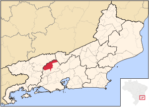
 Location of Vassouras in the state of Rio de Janeiro | |
 Vassouras Location of Vassouras in Brazil | |
| Coordinates: 22°24′14″S 43°39′46″W / 22.40389°S 43.66278°WCoordinates: 22°24′14″S 43°39′46″W / 22.40389°S 43.66278°W | |
| Country | |
| Region | Southeast |
| State | |
| Government | |
| • Prefeito | Severino Ananias Dias Filho |
| Area | |
| • Total | 552.438 km2 (213.298 sq mi) |
| Elevation | 434 m (1,424 ft) |
| Population (2020 [1]) | |
| • Total | 37,083 |
| Time zone | UTC-3 (UTC-3) |
| Website | [2] |
Vassouras (Portuguese: [vɐˈsowɾɐs], lit. 'Brooms') is a municipality located in the Brazilian state of Rio de Janeiro. Its population was 37,083 (2020) and its area is 552 km².[2]
Vassouras is known for its colonial-era coffee farms and significant royal structures of the Brazilian imperial family.

Panorama of Vassouras
References[]
Categories:
- Municipalities in Rio de Janeiro (state)
- Rio de Janeiro (state) geography stubs

