Thammampatti
Thammampatti
Dharma Nagar | |
|---|---|
City | |
 Thammampatti Located in Tamil Nadu, India | |
| Coordinates: 11°26′17″N 78°29′01″E / 11.43806°N 78.48361°ECoordinates: 11°26′17″N 78°29′01″E / 11.43806°N 78.48361°E | |
| Country | India |
| State | Tamil Nadu |
| District | Salem |
| Population (2020)[1] | |
| • Total | 35,804 |
| Languages | |
| • Official | Tamil |
| Time zone | UTC+5:30 (IST) |
| PIN | 636113 |
| Telephone code | 91-4282 |
| Vehicle registration | TN-77 |

Thammampatti Town Panchayat (also known as Dharma Nagar) is a Upgraded Special-Grade Town with a panchayat (local government) status in the Salem District of Tamil Nadu, India. The town is located between Pachamalai and the Kolli Hills on the River Swetha, and is known mainly for its fine wood carvings.
History[]
The region was ruled by several empires, including the three great empires – Chera, Chola and Pandyan, which shape the region's cuisine, culture, and architecture. After the fall of Kingdom of Mysore, the British Colonial rule during the modern period led to the emergence of Chennai, then known as Madras, as a metropolitan city. Modern-day Tamil Nadu was formed in 1956 after the reorganisation of states on linguistic lines. The state is home to a number of historic buildings, multi-religious pilgrimage sites, hill stations and three World Heritage sites.[2][3][4]
Population[]
The pincode 636113 - Thammampatti falls in Salem district situated in Tamil Nadu state, with a population 35804. The male and female populations are 17944 and 17860 respectively. The size of the area is about 65.95 square kilometer.
Geography[]
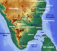

Tamil Nadu covers an area of 130,058 km2 (50,216 sq mi), and is the eleventh-largest state in India. The bordering states are Kerala to the west, Karnataka to the north-west and Andhra Pradesh to the north. To the east is the Bay of Bengal, and the state encircles the union territory of Puducherry. The southernmost tip of the Indian Peninsula is Kanyakumari which is the meeting point of the Arabian Sea, the Bay of Bengal, and the Indian Ocean.
Thammampatti is situated between Pachamalai and the Kolli Hills. The River Swetha flows through this town and joins the River Vasista to form the River Vellar, which flows into the Bay of Bengal at Parangipettai (Port Novo).
Climate[]
Tamil Nadu is mostly dependent on monsoon rains and so is prone to droughts when the monsoons fail. The climate ranges from dry sub-humid to semi-arid, and the state has two distinct periods of rainfall, the southwest monsoon from June to September and the northeast monsoon from October to December.
The annual rainfall of the state is about 945 mm (37.2 in) of which 48% is through the northeast monsoon, and 32% through the southwest monsoon. Since the state is entirely dependent on rains for recharging its water resources, monsoon failures lead to acute water scarcity and severe drought.[5] Tamil Nadu is divided into seven agro-climatic zones: northeast, northwest, west, southern, high rainfall, high altitude hilly, and Kaveri Delta (the most fertile agricultural zone). Salem District and Thammampatti fall into the Northwestern Zone.[6]
Demographics[]
Thammampatti had a voter population of 35,804 in 2020, with a total administration of approximately 7,000 households supplied with basic amenities.[1] According to the religious census of 2020, Tamil Nadu had 87.58% Hindus, 6.12% Christians, 5.86% Muslims, 0.12% Jains and 0.3% following other religions or no religion.[7]
Economics[]
The area's primary industry is agriculture, particularly the cultivation of tapioca. Wood carving artisan groups in the area of Gandhi Nagar (situated on the northwest side of the town) produce and export fine carvings both domestically to cities like Bangalore, Hyderabad, Mumbai and Kolkata and internationally to countries such as Singapore and Malaysia.[8]
Culture[]
Tamil Nadu is known for its rich tradition of literature, art, music and dance which continue to flourish today. Tamil Nadu is also known for its monumental ancient Hindu temples and classical form of dance Bharata Natyam.[9] Unique cultural features like Bharatanatyam[10] (dance), Tanjore painting,[11] and Tamil architecture were developed and continue to be practised in Tamil Nadu.[12]
The town of Thammampattiis well known for Jallikattu, a bull-riding sport that is typically hosted by the District Collector of Salem.
Residents of the town celebrate Karthigai Deepam by lighting a large lamp on the mountain Thirumankaradu malai. The mountain is approximately 500 ft in height and is situated in the Northwest region of the town.
The town historically had a special ritual for marriage wherein the men had to abduct the female of their choice, and if they were successful, the marriage would be performed.
Religion[]
is a historic Hindu temple located on the west side of bus stand . Next one for Ukarakadhali Lakhsmi Narasima Swamy Temple, its oldest temple and its built in 1600 (kp).
Jamia Masjid (Bazaar Street) serves as a main mosque that hosts the special Friday noon prayers known as jumu'ah. This mosque also hosts the Eid prayers when there is no Masjed Farzad musalla or eidgah available or nearby. The term is rendered similarly in transliterations from other languages, such as jame mosque, jami masjid, jameh mosque, jamia masjid, or jomeh mosque.[13]
Education[]

Tamil Nadu is one of the most literate states in India,[14] andTamil Nadu has performed reasonably well in terms of literacy growth during the decade 2001–2011. A survey conducted by the industry body Assocham ranks Tamil Nadu top among Indian states with about 100 per cent gross enrolment ratio (GER) in primary and upper primary education, and an analysis of primary school education in the state by Pratham also shows a low drop-off rate.[15] Tamil Nadu has 37 universities, 552 engineering colleges[16] 449 polytechnic colleges[17] and 566 arts and science colleges, 34,335 elementary schools, 5,167 high schools, 5,054 higher secondary schools and 5,000 hospitals.
The population of Thammampatti has an average literacy rate of 66%, with a male literacy rate of 74% and a female literacy rate of 58%.[1]
Tourism[]
The tourism industry of Tamil Nadu is the largest in India, with an annual growth rate of 16%. Tourism in Tamil Nadu is promoted by Tamil Nadu Tourism Development Corporation (TTDC), a government of Tamil Nadu undertaking. According to Ministry of Tourism statistics, 4.68 million foreign (20.1% share of the country) and 333.5 million domestic tourists (23.3% share of the country) visited the state in 2015, making it the most visited state in India by both domestic and foreign tourists.[18] The state boasts some of the grand Hindu temples built-in Dravidian architecture, three of which have been declared as UNESCO World Heritage Sites.[19][20]
Thammampatti features two architectural sites of note: the Meenakshi Amman Temple and the Jamia Masjid (Bazaar Street) Mosque.
Kolli Hills (46 km above Thammampatti) and (42 km above Thammampatti), located in the western and eastern regions of Thammampatti respectively, are popular spots for hiking. Residents can travel to both locations via bus.
, a hamlet of about 30 families and 10-15 tea shops, is located nearby in the dense forest region of the same name in the foothills of Kolli Hills. The falls of Aagaya Gangai flow through the hamlet.
Transport[]
The state has a total road length of 167,000 km (104,000 mi), of which 60,628 km (37,672 mi) are maintained by the Highways Department. This is nearly 2.5 times higher than the density of all-India road network.[21] The major road junctions are Chennai, Vellore, Madurai, Trichy, Coimbatore, Tiruppur, Salem, Tirunelveli, Thoothukudi, Karur, Kumbakonam, Krishnagiri, Dindigul and Kanniyakumari. Road transport is provided by state owned Tamil Nadu State Transport Corporation and State Express Transport Corporation. Almost every part of the state is well connected by buses 24 hours a day.
Thammampatti is well connected by bus transport via road to cities like Trichy, Namakkal, Karur, Madurai, Rasipuram, Erode, Kovai, Kallakurichi, Musiri, Kulithalai, Perambalur, Uppiliapuram, Thuraiyur, Samayapuram, Chennai, Vellore, Thiruvanamalai, Kolli hills, Seradi, Sendarapatti, Pachamalai, Bangalore, Vazhapadi, Attur and Salem. In addition to the main bus routes, minibuses play an important role in connecting villages within the hinterland. The nearest railway station is located in Attur (28 km), Thuraiyur (36 km), Trichy (79 km), Salem (59 km) and Rasipuram (40 km). The nearest airport is Tiruchirappalli International Airport, which offers both international and domestic flights and is approximately 85 km away from the town. the second closest airport, Salem Airport (87 km), offers domestic services only to Chennai.
Thammampatti is located on the border of 4 districts: Salem, Trichy, Namakkal, and Perambalur. It is located 59 km from the headquarter Salem, 79 km from Trichy, 65 km from Namakkal and 63 km from Perambalur.
TNSTC SALEM Division bus depot is having a Thammampatti branch (ATC Nagar).
List of areas in Thammampatti[]
This section may contain indiscriminate, excessive, or irrelevant examples. (March 2018) |
- Udayarpalayam
- Ulipuram
- Palakkarai
- (Selva Nagar)
References[]
- ^ Jump up to: a b c http://www.censusindia.gov.in/pca/SearchDetails.aspx?Id=686692
- ^ UNESCO 2012.
- ^ Press Information Bureau releases 2012.
- ^ "The Living culture of the Tamils; The UNESCO Courier: a window open on the world" (PDF). The UNESCO Courier. XXXVII, 3, 1984. March 1984. Archived (PDF) from the original on 17 April 2018. Retrieved 28 May 2018.
- ^ UN, system of organisations 2012.
- ^ "Agricultural Geography". Retrieved 12 March 2021.
- ^ "Population By Religious Community – Tamil Nadu" (XLS). Office of The Registrar General and Census Commissioner, Ministry of Home Affairs, Government of India. 2011. Archived from the original on 13 September 2015. Retrieved 13 September 2015.
- ^ "After seven long years,Thammampatti wood carvings of Salem to get GI tag". 1 July 2020. Retrieved 12 March 2021.
- ^ Thakur, A. P.; Pandey, Sunil (2009). 21st Century India: View and Vision. p. 320. ISBN 9788182202696.
- ^ "Tamilnadu – The Dance of Celestial Deities". Tamilnadu.com. 12 February 2014. Archived from the original on 25 March 2014. Retrieved 25 March 2014.
- ^ "Thanjavur Painting – Tamil Art". Tamilnadu.com. 18 January 2013. Archived from the original on 18 July 2013. Retrieved 15 February 2013.
- ^ "Arts Archives – Tamilnadu". Tamilnadu.com. 23 January 2013. Archived from the original on 31 January 2013. Retrieved 31 January 2013.
- ^ "DawateIslami Khuddam-ul-Masajid". buildamasjid.net. Archived from the original on 23 August 2019. Retrieved 24 October 2019.
- ^ The Times of India & 14 May 2003.
- ^ The Guardian & 15 March 2011.
- ^ List of Engineering colleges in Tamilnadu, January –31, 2015, AICTE David, archived from the original on 5 January 2015
- ^ District wise Polytechnics 2011.
- ^ "India Tourism Statistics" (PDF). Archived (PDF) from the original on 17 May 2017. Retrieved 24 May 2017.
- ^ UNESCO Chola temples 2012.
- ^ UNESCO Mahabalipuram temples 2012.
- ^ Tamil Nadu Highways 2012.
| show Salem District |
|---|
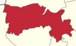
- Cities and towns in Salem district