The Cliffs Valley, South Carolina
The Cliffs Valley, South Carolina | |
|---|---|
 The Cliffs Valley | |
| Coordinates: 35°8′13″N 82°26′58″W / 35.13694°N 82.44944°WCoordinates: 35°8′13″N 82°26′58″W / 35.13694°N 82.44944°W | |
| Country | United States |
| State | South Carolina |
| County | Greenville |
| Area | |
| • Total | 6.5 sq mi (16.8 km2) |
| • Land | 6.4 sq mi (16.7 km2) |
| • Water | 0.04 sq mi (0.1 km2) |
| Elevation | 1,165 ft (355 m) |
| Time zone | UTC-5 (Eastern (EST)) |
| • Summer (DST) | UTC-4 (EDT) |
| ZIP Code | 29690 (Travelers Rest) |
| Area code(s) | 864 |
| FIPS code | 45-71658 |
| GNIS feature ID | 2812960[2] |
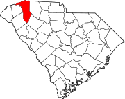
The Cliffs Valley is a resort community and census-designated place (CDP) in Greenville County, South Carolina, United States. It was first listed as a CDP prior to the 2020 census.[2]
The CDP is on the northern edge of Greenville County, extending north to the North Carolina border. U.S. Route 25 forms the western edge of the CDP; the highway leads south 21 miles (34 km) to Greenville and north 16 miles (26 km) to Hendersonville, North Carolina.
The community is in the Blue Ridge Mountains and its foothills. 2,900-foot (880 m) Panther Mountain and 3,025-foot (922 m) Corbin Mountain are on the northern border of the CDP, separated by Panther Gap. 2,800-foot (850 m) Pruett Mountain extends south into the middle of the CDP. The community is drained by Terry Creek, which flows south to the North Saluda River just outside the CDP.
The CDP is home to The Cliffs Valley Golf Course.
References[]
- ^ "2020 U.S. Gazetteer Files – South Carolina". United States Census Bureau. Retrieved September 9, 2021.
- ^ a b "The Cliffs Valley Census Designated Place". Geographic Names Information System. United States Geological Survey.
- Census-designated places in Greenville County, South Carolina
- Census-designated places in South Carolina
- South Carolina geography stubs


