Thermi
Thermi
Θέρμη | |
|---|---|
 | |
 Thermi Location within the region 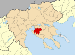 | |
| Coordinates: 40°33′N 23°01′E / 40.550°N 23.017°ECoordinates: 40°33′N 23°01′E / 40.550°N 23.017°E | |
| Country | Greece |
| Administrative region | Central Macedonia |
| Regional unit | Thessaloniki |
| Government | |
| • Mayor | Thodoros Papadopoulos |
| Area | |
| • Municipality | 382.11 km2 (147.53 sq mi) |
| • Municipal unit | 100.94 km2 (38.97 sq mi) |
| Elevation | 63 m (207 ft) |
| Population (2011)[1] | |
| • Municipality | 53,201 |
| • Municipality density | 140/km2 (360/sq mi) |
| • Municipal unit | 25,145 |
| • Municipal unit density | 250/km2 (650/sq mi) |
| Community | |
| • Population | 16,004 (2011) |
| Time zone | UTC+2 (EET) |
| • Summer (DST) | UTC+3 (EEST) |

Thermi (Greek: Θέρμη) is a town and a municipality in the Thessaloniki regional unit, Greece. Its population was 53,201 at the 2011 census. It is located over the site of ancient Therma.[1]
Municipality[]

View from the road

Dam of Thermi

Technology center of BETA CAE Systems

Interior of the International Hellenic University
The municipality Thermi was formed at the 2011 local government reform by the merger of the following 3 former municipalities, that became municipal units:[2]
The municipality Thermi has an area of 382.106 km2, the municipal unit Thermi has an area of 100.943 km2, and the community Thermi has an area of 55.90 km2.[3]
Education[]
This section needs expansion. You can help by . (April 2015) |
Pinewood - The American International School is located in Thermi.[4]
References[]
- ^ a b c "Απογραφή Πληθυσμού - Κατοικιών 2011. ΜΟΝΙΜΟΣ Πληθυσμός" (in Greek). Hellenic Statistical Authority.
- ^ "ΦΕΚ A 87/2010, Kallikratis reform law text" (in Greek). Government Gazette.
- ^ "Population & housing census 2001 (incl. area and average elevation)" (PDF) (in Greek). National Statistical Service of Greece.
- ^ Home page (Archive). Pinewood - The American International School. Retrieved on April 28, 2015. "14th km Thessalonikis - N.Moudanion, P.O. Box 60606, 57001 Thermi, Thessaloniki, Greece"
Administrative division of the Central Macedonia Region | ||
|---|---|---|
| ||
| Regional unit of Chalkidiki | 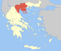 | |
| Regional unit of Imathia | ||
| Regional unit of Kilkis |
| |
| Regional unit of Pella | ||
| Regional unit of Pieria | ||
| Regional unit of Serres | ||
| Regional unit of Thessaloniki | ||
| ||
This Central Macedonia location article is a stub. You can help Wikipedia by . |
Categories:
- Municipalities of Central Macedonia
- Populated places in Thessaloniki (regional unit)
- Central Macedonia geography stubs