Sithonia
Sithonia
Σιθωνία | |
|---|---|
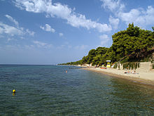
 Klimataria beach | |
 Sithonia Location within the region  | |
| Coordinates: 40°06′00″N 23°52′30″E / 40.10000°N 23.87500°ECoordinates: 40°06′00″N 23°52′30″E / 40.10000°N 23.87500°E | |
| Country | Greece |
| Administrative region | Central Macedonia |
| Area | |
| • Municipality | 516.8 km2 (199.5 sq mi) |
| • Municipal unit | 322.9 km2 (124.7 sq mi) |
| Population (2011)[1] | |
| • Municipality | 12,394 |
| • Municipality density | 24/km2 (62/sq mi) |
| • Municipal unit | 8,841 |
| • Municipal unit density | 27/km2 (71/sq mi) |
| Time zone | UTC+2 (EET) |
| • Summer (DST) | UTC+3 (EEST) |
| Vehicle registration | ΧΚ |

Sithonia (Greek: Σιθωνία), also known as Longos, is a peninsula of Chalkidiki, which itself is located on a larger peninsula within Greece. The Kassandra Peninsula lies to the west of Sithonia and the Mount Athos peninsula to the east. Sithonia is also a municipality, covering the Sithonia peninsula. The seat of the municipality is the town Nikiti.[2]
Geography[]


Gulfs that surround the peninsula are the Singitic Gulf to the east and the Toronean Gulf to the west. The mountains Itamos and Dragoudelis are in the center of the peninsula. The landscape is covered with vineyards, forests, grasslands, shrubland and mountains. Amongst the many historic places in Sithonia is the ancient city, the castle and the church of Agios Athanasios in Toroni, the windmills in Sykia and the 16th century church in Nikiti.
In the northern part of the peninsula are the popular beaches of Ai Giannis, Kalogria, Elia and Lagomandra on the west coast and Livrochios, Karidi, Kavourotripes and Platanitsi on the east coast. The beaches in the southern part include Azapiko, Tristinika, Kalamitsi and Kriaritsi.
Porto Koufo, is the largest natural harbor in Greece, which is mentioned by Thucydides as "hollow harbor"; it appears to be the fishing spot in the area. South, from the harbour's exit there is , the most southern part of Sithonia, a very impressive area which puts its visitors under a spell with its rocky secluded beaches.
The main villages in the peninsula are Nikiti, Neos Marmaras, Parthenonas, Sarti, Sykia, Vourvourou and Agios Nikolaos.
In the middle of Sithonia peninsula, near the village of Neos Marmaras, is the holiday resort of Porto Carras; the place of the 2003 European Union leaders Summit. In summer the waterfront areas of Neos Maramaras, Nikiti and Sarti are especially busy.
Municipality[]
The municipality Sithonia was formed at the 2011 local government reform by the merger of the following 2 former municipalities, that became municipal units:[2]
- Sithonia
- Toroni
The municipality has an area of 516.848 km2, the municipal unit 322.875 km2.[3]
Places[]
- Agios Nikolaos
- Camping [4]
- or Elia, or Olive Beach
- Metamorfosi
- Neos Marmaras
- Nikiti
- Ormos Panagias
- Porto Carras Grand Resort
- Porto Koufos or Porto Koufo
- or Pyrgadikia
- Sarti
- Sykia
- Toroni
- Vourvourou
External links[]
- Visit Sithonia
- Sithonia Guide
- Sithonia in Chalkidiki
- Sithonia Greece travel guide and information
- Visitor guide of Sithonia
| Wikimedia Commons has media related to Sithonia. |
References[]
- ^ a b "Απογραφή Πληθυσμού - Κατοικιών 2011. ΜΟΝΙΜΟΣ Πληθυσμός" (in Greek). Hellenic Statistical Authority.
- ^ a b "ΦΕΚ A 87/2010, Kallikratis reform law text" (in Greek). Government Gazette.
- ^ "Population & housing census 2001 (incl. area and average elevation)" (PDF) (in Greek). National Statistical Service of Greece.
- ^ "Armenistis camping-Home page". Archived from the original on 2000-10-17.
Administrative division of the Central Macedonia Region | ||
|---|---|---|
| ||
| Regional unit of Chalkidiki | 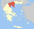 | |
| Regional unit of Imathia | ||
| Regional unit of Kilkis |
| |
| Regional unit of Pella | ||
| Regional unit of Pieria | ||
| Regional unit of Serres | ||
| Regional unit of Thessaloniki | ||
| ||
This Central Macedonia location article is a stub. You can help Wikipedia by . |
- Peninsulas of Greece
- Municipalities of Central Macedonia
- Populated places in Chalkidiki
- Geography of ancient Chalcidice
- Central Macedonia geography stubs