Tojo Una-Una Regency
Tojo Una-Una Regency
Kabupaten Tojo Una-Una | |
|---|---|
 Coat of arms | |
| Motto(s): Sivia Patuju (One Purpose) | |
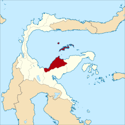 Location within Central Sulawesi | |
| Coordinates: 0°52′32″S 121°37′47″E / 0.87556°S 121.62972°E | |
| Country | Indonesia |
| Province | Central Sulawesi |
| Capital | Ampana |
| Government | |
| • Regent | Muhammad Lahay |
| • Vice Regent | Admin A.S Lasimpala |
| Area | |
| • Total | 5,721.51 km2 (2,209.09 sq mi) |
| Population (2020 Census)[1] | |
| • Total | 163,829 |
| • Density | 29/km2 (74/sq mi) |
| Time zone | UTC+8 (ICST) |
| Area code | (+62) 464 |
| Website | tojounaunakab |


Tojo Una-Una Regency is a regency of Central Sulawesi, Indonesia. The administrative centre is at Ampana town, on the Sulawesi 'mainland'. While the Regency includes a considerable area on the eastern peninsula of Sulawesi, it also includes the Togian Islands in the Gulf of Tomini. The total area covers 5,721.51 km2 and the population was 134,945 at the 2010 Census and 163,829 at the 2020 Census.[2]
History[]
In 1999, Tojo Una-Una Regency was created out of the eastern portion of Poso Regency.[3]
Administration[]
A the time of the 2010 Census, the Tojo Una-Una Regency was divided into nine districts (kecamatan). Subsequent to 2010, three additional districts have been created - Batudaka, Ratolindo and Talatako. These are tabulated below with their areas and their 2010 and 2020 Census populations.[4]
| Name | Area in km2 |
Population Census 2010 |
Population Census 2020[5] |
|---|---|---|---|
| (West Tojo) |
1,092.27 | 11,358 | 12,992 |
| 1,065.48 | 12,488 | 13,928 | |
| 1,767.11 | 14,669 | 18,272 | |
| 796.02 | 21,610 | 27,614 | |
| (Ampana Town) |
175.42 | 39,289 | 20,854 |
| Ratolindo | 61.88 | (a) | 28,735 |
| Total Sulawesi mainland | 4,958.18 | 99,414 | 122,395 |
| 146.16 | 12,455 | 8,236 | |
| Batudaka | 151.91 | (b) | 5,796 |
| Togean | 229.51 | 9,160 | 10,734 |
| (Walea Islands) |
67.60 | 10,065 | 5,568 |
| (Great Walea) |
84.51 | 3,851 | 4,629 |
| Talatako | 83.64 | (c) | 6,471 |
| Total Togean Islands | 763.33 | 35,531 | 41,434 |
Notes:
(a) The 2010 Census population of Ratolindo district is included in the figure for Ampana Kota district, from which it was cut out.
(b) The 2010 Census population of Batudaka district is included in the figure for Una-Una district, from which it was cut out.
(c) The 2010 Census population of Talatako district is included in the figure for Walea Kepulauan district, from which it was cut out.
Dive sites[]
The best place to do diving is Una Una volcano island.
Based on Badan Koordinasi Survei dan Pemetaan Nasional (Bakosurtanal) or Coordinating Agency for Surveys and Mapping, there are 33 dive sites disperses from north to south beaches of the Togian Islands with fringing reefs, barrier reefs, patch reefs and atolls. The area has the third most biodiversity in the world and is a series of Bunaken National Marine Park and Raja Ampat Islands.[6]
References[]
- ^ Badan Pusat Statistik, Jakarta, 2021.
- ^ Badan Pusat Statistik, Jakarta, 2021.
- ^ Sangadji, Ruslan (21 February 2007). "Residents say a divided Poso could be a more peaceful place". The Jakarta Post.
- ^ Badan Pusat Statistik, Jakarta, 2021.
- ^ Badan Pusat Statistik, Jakarta, 2021.
- ^ "Surga Dasar Laut yang Memukau Perairan Togean". May 13, 2012.
External links[]
| show Regencies and cities of Central Sulawesi |
|---|
| show Authority control |
|---|
Coordinates: 0°52′32″S 121°37′47″E / 0.87556°S 121.62972°E
This Central Sulawesi location article is a stub. You can help Wikipedia by . |
- Regencies of Central Sulawesi
- Sulawesi geography stubs