Tornado outbreak of April 13–16, 2012
 A violent EF4 tornado near Marquette, Kansas. | |
| Type | Tornado outbreak |
|---|---|
| Duration | April 13–16, 2012 |
| Highest winds |
|
| Tornadoes confirmed | 113 confirmed |
| Max. rating1 | EF4 tornado |
| Duration of tornado outbreak2 | 2 days, 16 hours, 37 minutes |
| Largest hail | 4.50 in (11.4 cm) in diameter in Randolph, Kansas, on April 15 |
| Casualties | 6 fatalities, 101 injuries.[2] |
| Damage | At least $283 million (in Wichita, unknown elsewhere)[1] |
| 1Most severe tornado damage; see Enhanced Fujita scale 2Time from first tornado to last tornado | |
From April 13 to 16, 2012, a major tornado outbreak occurred across a large portion of the Great Plains. The storms resulted in 6 tornado-related fatalities, all of which occurred as a result of a nighttime EF3 tornado that caused major damage in and around Woodward, Oklahoma. Numerous other tornadoes occurred, including a violent EF4 tornado that passed near Marquette, Kansas, and an EF3 that caused major damage in Wichita.
Meteorological synopsis[]
An impressive low pressure area and associated trough began tracking into the Great Plains on April 13, and a slight risk of severe weather was issued. The outlook mentioned the possibility of tornadoes, including the risk for isolated strong tornadoes. No strong tornadoes occurred, though an EF1 tornado caused considerable damage in Norman, Oklahoma.
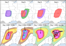
For only the second time in history (previously for April 7, 2006), a day two high risk [3] of severe weather was issued by the Storm Prediction Center. In the discussion, the SPC stated that a major tornado outbreak was likely across central Kansas and north-central Oklahoma during the afternoon and overnight hours of April 14, with long-tracked violent tornadoes likely. It was later expanded to include a second high risk area across much of Nebraska, where a rare 45% tornado probability was given during the late morning update on April 13. During the morning hours on the 14th, the high risk area was expanded again to combine the two separate areas into a single large one. Later in the day, the 45% tornado probability was shifted from Nebraska south to Kansas and northern Oklahoma. A large outbreak of tornadoes impacted the Great Plains states on April 14, and several PDS Tornado Warnings were issued during the outbreak. Initially, most of the tornadoes were small or remained over open country, though more significant tornado activity began to develop throughout the day. A high-end EF2 tornado struck Creston, Iowa, flipping vehicles and causing major structural damage to homes and other buildings in town. Another EF2 wedge tornado struck Thurman, Iowa, damaging 75% of the town. In Nebraska, a strong EF2 tornado destroyed outbuildings and badly damaged a home near Cook, while a large and violent EF4 tornado leveled a home and debarked trees near Marquette, Kansas.[4] Later that evening, a cyclic supercell thunderstorm developed in northern Oklahoma before moving into southern Kansas, producing multiple tornadoes along the way. This included a large EF3 wedge tornado that destroyed homes near Conway Springs. As this supercell moved into Wichita around 10:15 pm CDT (0315 UTC), another large EF3 wedge tornado touched down and caused major damage in the southeastern part of the city. Staff at the Wichita National Weather Service Weather Forecast Office at Wichita Mid-Continent Airport were forced to hand over responsibility for their County Warning Area to the National Weather Service office in Topeka and take shelter at about 10:00 pm CDT (0300 UTC), returning to duty half an hour later. Another supercell thunderstorm also produced two EF3 wedge tornadoes that passed near Fellsburg and Hudson, causing significant damage.[5]
Around 10:00 p.m. CDT (0300 UTC), a broken squall line began to form across the eastern portions of the Texas and Oklahoma panhandles; a thunderstorm developed ahead of the northern line segment in northwestern Wheeler County, Texas, at approximately 10:30 p.m. CDT (0330 UTC), and began developing supercell characteristics as it tracked northeastward into the Oklahoma counties of Ellis and Roger Mills. A tornado warning was issued for Ellis, Harper and Woodward counties at 12:00 am CDT (0500 UTC) on April 15 after weather spotters reported a tornado spawned by this supercell located 7 miles (11 km) southeast of Gage in Ellis County.[6] This high-end EF3 tornado later struck Woodward, Oklahoma, at 12:20 am CDT (0520 UTC), killing six people. Multiple homes and businesses were destroyed in Woodward, and all fatalities occurred as a result of destroyed mobile homes.[7][8] Additional weak tornadoes occurred on April 15 and 16 before the outbreak came to an end.[9]
Tornadoes[]
| EFU | EF0 | EF1 | EF2 | EF3 | EF4 | EF5 | Total |
|---|---|---|---|---|---|---|---|
| 0 | 68 | 36 | 3 | 5 | 1 | 0 | 113 |
April 13 event[]
| hideList of reported tornadoes - Friday, April 13, 2012 | ||||||
|---|---|---|---|---|---|---|
| Oklahoma | ||||||
| EF1 | Norman | McClain, Cleveland | 35°13′N 97°26′W / 35.22°N 97.44°W | 2059 | 5.5 miles (8.9 km) | This tornado caused considerable damage in Norman, and was broadcast live on television via news helicopter. Numerous homes and businesses sustaining varying degrees of damage along the path, and many trees and power poles were downed. An apartment building had its roof blown off, and a vacant paint store sustained roof loss and exterior wall collapse. Twenty people were injured by the tornado, though only one required hospitalization.[10] |
| EF0 | NNW of Shawnee | Pottawatomie | 35°23′N 97°00′W / 35.39°N 97.00°W | 2224 | 0.3 miles (0.48 km) | A small outbuilding was damaged by this brief, weak tornado. |
| EF0 | SE of Blair (1st tornado) | Jackson | 34°46′N 99°19′W / 34.76°N 99.31°W | 2310 | 0.5 miles (0.80 km) | Brief tornado remained over open country. No damage was reported. |
| EF0 | SE of Blair (2nd tornado) | Jackson | 34°45′N 99°18′W / 34.75°N 99.30°W | 2316 | 0.5 miles (0.80 km) | Brief tornado remained over open country. No damage was reported. |
| EF0 | E of Blair | Jackson | 34°47′N 99°13′W / 34.78°N 99.21°W | 2330 | 2 miles (3.2 km) | Tornado remained over open country. No damage was reported. |
| EF0 | SE of Cooperton | Kiowa | 34°52′N 98°52′W / 34.86°N 98.86°W | 0025 | 0.5 miles (0.80 km) | Brief tornado remained over open country. No damage was reported. |
| EF0 | S of Cooperton (1st tornado) | Kiowa | 34°52′N 98°52′W / 34.86°N 98.87°W | 0027 | 0.2 miles (0.32 km) | Brief tornado remained over open country. No damage was reported. |
| EF1 | S of Cooperton (2nd tornado) | Kiowa | 34°51′N 98°53′W / 34.85°N 98.89°W | 0028 | 5 miles (8.0 km) | A silo was damaged and another structure sustained roof damage as a result of this large tornado. |
| EF0 | NE of Cooperton | Kiowa | 34°56′N 98°50′W / 34.94°N 98.84°W | 0052 | 6 miles (9.7 km) | Large tornado remained over open country, causing no damage. |
| EF0 | SSE of Carnegie (1st tornado) | Caddo | 35°01′N 98°34′W / 35.02°N 98.56°W | 0136 | 2 miles (3.2 km) | Tornado remained over open country, causing no damage. |
| EF0 | SSE of Carnegie (2nd tornado) | Caddo | 35°00′N 98°33′W / 35.00°N 98.55°W | 0142 | 0.3 miles (480 m) | Tornado remained over open country, causing no damage. |
| EF0 | SSE of Carnegie (3rd tornado) | Caddo | 35°01′N 98°33′W / 35.01°N 98.55°W | 0150 | 4 miles (6.4 km) | Tornado remained over open country, causing no damage. |
| Sources: SPC Storm Reports for 04/13/12, NCDC Storm Events Database | ||||||

April 14 event[]
| hideList of reported tornadoes - Saturday, April 14, 2012 | ||||||
|---|---|---|---|---|---|---|
| Oklahoma | ||||||
| EF1 | NNW of Mustang | Canadian | 35°24′N 97°44′W / 35.40°N 97.74°W | 0552 | 2 miles (3.2 km) | Numerous frame homes sustained minor damage, mostly to roofs and siding, and had garage doors and windows blown out. One home sustained partial roof loss. Four mobile homes also sustained minor damage, and many trees, fences, and power lines were downed. |
| EF0 | NW of Woodward | Woodward | 36°32′N 99°31′W / 36.53°N 99.52°W | 2049 | 4 miles (6.4 km) | This tornado remained over open country, causing no damage. |
| EF1 | N of Woodward | Woodward, Harper | 36°32′N 99°23′W / 36.53°N 99.39°W | 2059 | 0.5 miles (0.80 km) | This brief tornado damaged a barn. |
| EF0 | WNW of Freedom | Woodward | 36°47′N 99°13′W / 36.79°N 99.21°W | 2126 | 0.2 miles (320 m) | Brief tornado remained over open country, causing no damage. |
| EF0 | NNW of Freedom | Woods | 36°49′N 99°10′W / 36.81°N 99.16°W | 2133 | 0.3 miles (480 m) | Brief tornado remained over open country, causing no damage. |
| EF0 | SSW of Tangier | Woodward | 36°14′N 99°35′W / 36.24°N 99.59°W | 2218 | 0.2 miles (320 m) | Brief tornado remained over open country, causing no damage. |
| EF0 | SSW of Tangier | Woodward | 36°16′N 99°34′W / 36.27°N 99.57°W | 2224 | 0.2 miles (320 m) | Brief tornado remained over open country, causing no damage. |
| EF0 | NE of Mooreland | Woodward | 36°31′N 99°07′W / 36.52°N 99.11°W | 2315 | 0.2 miles (320 m) | Brief tornado remained over open country, causing no damage. |
| EF0 | ESE of Mooreland | Woodward | 36°24′N 99°05′W / 36.40°N 99.09°W | 2350 | 0.1 miles (160 m) | Brief tornado remained over open country, causing no damage. |
| EF0 | ENE of Mooreland | Woodward | 36°31′N 98°59′W / 36.51°N 98.99°W | 2351 | 0.2 miles (320 m) | A brief multiple-vortex tornado remained over open country, causing no damage. |
| EF0 | SSW of Waynoka | Major | 36°28′N 98°56′W / 36.46°N 98.94°W | 0001 | 0.1 miles (160 m) | Brief tornado remained over open country, causing no damage. |
| EF1 | S of Waynoka | Major, Woods | 36°29′N 98°53′W / 36.49°N 98.88°W | 0006 | 7.2 miles (11.6 km) | Equipment at an oil field was damaged by this tornado, causing a fire. |
| EF0 | SE of Waynoka | Woods | 36°33′N 98°50′W / 36.55°N 98.83°W | 0019 | 1 mile (1.6 km) | This tornado remained over open country, causing no damage. |
| EF0 | E of Waynoka to NE of Hopeton | Woods | 36°35′N 98°42′W / 36.59°N 98.70°W | 0030 | 9 miles (14 km) | This tornado remained over open country, causing no damage. |
| EF1 | W of Cherokee | Alfalfa | 36°41′N 98°31′W / 36.69°N 98.52°W | 0047 | 10 miles (16 km) | This likely significant tornado was photographed and caught on video by many storm chasers, though it avoided well-built structures. Farm equipment, two metal barns, and some outbuildings were damaged or destroyed. |
| EF0 | NW of Cherokee to NW of Amorita | Alfalfa | 36°47′N 98°23′W / 36.78°N 98.39°W | 0057 | 12 miles (19 km) | This tornado occurred simultaneously with the previous tornado. Several trees and outbuildings were damaged. |
| EF1 | E of Byron to NE of Danville, KS | Alfalfa, Grant, Harper (KS) | 36°54′N 98°13′W / 36.90°N 98.22°W | 0119 | 36.6 miles (58.9 km) | This large, long-tracked, and likely significant stovepipe tornado began in Oklahoma before crossing into Kansas, passing near the towns of Amorita, Manchester, Bluff City and Anthony. Damage was limited to trees in Oklahoma, though farmsteads sustained considerable damage in Kansas. A small semi-truck at a farm was tossed 140 yards over a fence, and a nearby home had windows blown out and lost most of its roof shingles. A pickup truck and a tractor were moved as well. At a second farmstead, a house had one of its exterior garage walls blown out, broken windows, and sustained damage from a tree falling onto it. A second nearby home sustained partial roof removal, while a small airplane hangar, metal sheds, and a barn were also destroyed. At an abandoned farmstead, a home sustained major structural damage. Many trees were snapped or uprooted as well. |
| EF3 | N of Arnett to NE of Woodward | Ellis, Woodward | 36°26′N 99°23′W / 36.43°N 99.39°W | 0442 | 31 miles (50 km) | 6 deaths – See section on this tornado – There were 29 injuries. |
| Kansas | ||||||
| EF1 | NW of Burdett | Pawnee | 38°12′N 99°32′W / 38.20°N 99.54°W | 1638 | 4.1 miles (6.6 km) | This tornado struck a farmstead, damaging an outbuilding and the roof of a house. |
| EF1 | Rush Center to ESE of Loretta | Rush | 38°26′N 99°20′W / 38.43°N 99.33°W | 1714 | 17.2 miles (27.7 km) | A pivot sprinkler and a few outbuildings were damaged, and trees were downed along the path. |
| EF0 | S of Russell | Russell | 38°50′N 98°51′W / 38.83°N 98.85°W | 1823 | 0.75 miles (1.21 km) | A barn suffered minor damage as a result of this brief, weak tornado. |
| EF0 | NE of Russell | Russell | 38°56′N 98°43′W / 38.93°N 98.72°W | 1834 | 1.75 miles (2.82 km) | This tornado remained over open country, causing no damage. |
| EF0 | WSW of Lucas | Russell | 39°03′N 98°37′W / 39.05°N 98.61°W | 1843 | 3 miles (4.8 km) | This tornado remained over open country, causing no damage. |
| EF1 | NNE of Dodge City to W of Burdett | Ford, Hodgeman | 37°55′N 99°52′W / 37.91°N 99.87°W | 1857 | 32.9 miles (52.9 km) | This long-tracked cone tornado remained mostly over open fields, remaining on the ground for over one hour. Barns, outbuildings, and pivot sprinklers sustained damage, and trees were downed along the path. |
| EF1 | S of Tipton | Mitchell | 39°19′N 98°28′W / 39.32°N 98.46°W | 1903 | 3 miles (4.8 km) | Homes sustained roof and siding damage, and garages and outbuildings were damaged or destroyed. Trees and power poles were downed as well. |
| EF1 | E of Minneola | Clark | 37°25′N 99°44′W / 37.41°N 99.74°W | 1924 | 6.3 miles (10.1 km) | Several trees were downed along the path of this tornado. |
| EF1 | NE of Burdett to SSW of Rush Center | Pawnee, Rush | 38°19′N 99°25′W / 38.31°N 99.41°W | 2024 | 4.7 miles (7.6 km) | Several trees were downed and an outbuilding was damaged. |
| EF1 | SE of Lewis | Edwards | 37°50′N 99°12′W / 37.83°N 99.20°W | 2028 | 9.4 miles (15.1 km) | Several trees and power lines were downed. |
| EF1 | E of Coldwater | Comanche, Barber | 37°19′N 99°00′W / 37.32°N 99.00°W | 2059 | 10.9 miles (17.5 km) | Several trees and power lines were downed and a barn was damaged. |
| EF0 | ENE of Timken | Rush | 38°29′N 99°09′W / 38.48°N 99.15°W | 2104 | 0.9 miles (1.4 km) | This brief tornado remained over open country and caused no damage. |
| EF1 | ESE of Seward to NNE of Hudson | Stafford | 38°09′N 98°44′W / 38.15°N 98.73°W | 2125 | 9.75 miles (15.69 km) | Several trees and power poles were downed along the path. |
| EF1 | NW of Hudson | Stafford | 38°06′N 98°46′W / 38.10°N 98.77°W | 2135 | 14.4 miles (23.2 km) | Power poles and a few trees were downed along the path. |
| EF0 | NW of Sawyer | Pratt | 37°29′N 98°43′W / 37.49°N 98.71°W | 2144 | 2.3 miles (3.7 km) | A weak tornado remained over open country and caused no damage. |
| EF0 | SSE of Ellinwood | Barton | 38°17′N 98°32′W / 38.28°N 98.54°W | 2150 | 0.5 miles (0.80 km) | This brief tornado remained over an open field and caused no damage. |
| EF0 | W of Penalosa | Kingman | 37°43′N 98°23′W / 37.72°N 98.39°W | 2202 | 0.5 miles (0.80 km) | This brief tornado remained over an open field and caused no damage. |
| EF0 | ENE of Cairo | Pratt | 37°40′N 98°30′W / 37.67°N 98.50°W | 2208 | 2.3 miles (3.7 km) | This tornado remained over open country, causing no damage. |
| EF4 | N of Lyons to NW of Salina | Rice, Ellsworth, McPherson, Saline | 38°28′N 98°05′W / 38.46°N 98.08°W | 2232 | 40.25 miles (64.78 km) | A large, violent, and long-tracked tornado caused damage to farms along its path, passing near Kanopolis Lake, Marquette, Falun, Smolan and Bavaria before dissipating near Salina. At one farmstead, a house was swept away with only part of a staircase left on the foundation. Many large trees in this area were shredded and debarked, a car was tossed and flipped onto its roof, and a gravel road was scoured and dug out to a depth of around 5 inches (13 cm). Five wooden power poles were snapped and thrown out into a field, and two vehicle axles from an unknown location were found nearby. Near the end of the path, large trees and a house sustained severe damage near Smolan. Another home at the edge of the damage path sustained gutter and shingle damage, and a metal road sign that originated near Kanopolis Lake was found 27 miles away at the Salina Municipal Golf Course.[11] |
| EF0 | N of New Cambria | Saline | 38°53′N 97°30′W / 38.88°N 97.50°W | 2350 | 0.25 miles (400 m) | This brief tornado remained over open country, causing no damage. |
| EF0 | N of Kingman | Kingman | 37°41′N 98°07′W / 37.69°N 98.11°W | 2355 | 0.25 miles (0.40 km) | This tornado remained over open country, causing no damage. |
| EF1 | NNE of New Cambria to SW of Manchester | Saline, Ottawa, Dickinson | 38°57′N 97°25′W / 38.95°N 97.42°W | 2355 | 16.8 miles (27.0 km) | A large tornado blew the roof off of a farmhouse, which also sustained damage from projectiles. Nearby outbuildings were destroyed, and a hay baler was overturned. A gas transfer station near Niles was also damaged, and many trees and power poles were downed. Several other farmsteads sustained outbuilding damage along the path. This tornado was likely strong, though it avoided well-built structures. |
| EF0 | N of Pretty Prairie | Reno | 37°49′N 98°01′W / 37.81°N 98.02°W | 0010 | 0.25 miles (400 m) | This brief tornado remained over open country, causing no damage. |
| EF0 | ENE of Manchester | Dickinson | 39°08′N 97°10′W / 39.14°N 97.17°W | 0031 | 3 miles (4.8 km) | This brief tornado remained over open country, causing no damage. |
| EF0 | ESE of Moundridge | McPherson | 38°11′N 97°29′W / 38.19°N 97.49°W | 0103 | 1 mile (1.6 km) | This brief tornado remained over open country, causing no damage. |
| EF1 | E of Moundridge to W of Goessel | McPherson, Marion | 38°12′N 97°28′W / 38.20°N 97.47°W | 0105 | 7 miles (11 km) | Numerous outbuildings were damaged or destroyed at a farmstead, and a house sustained damage to its roof. A barn was also damaged. |
| EF3 | WNW of Greensburg to E of Macksville | Kiowa, Edwards, Stafford | 37°37′N 99°20′W / 37.62°N 99.33°W | 0127 | 38 miles (61 km) | This strong, long-tracked, mile-wide EF3 wedge tornado passed near Fellsburg. Farm fields were heavily scoured and homes sustained major structural damage, including loss of roofs and exterior walls. Large trees were denuded and debarked, one of which was found with an auger bit embedded into the trunk. Pivot irrigation sprinklers, outbuildings, and farm machinery sustained severe damage as well. |
| EF1 | NE of Greensburg | Kiowa | 37°41′N 99°15′W / 37.68°N 99.25°W | 0140 | 4.9 miles (7.9 km) | Satellite tornado to the previous EF3 wedge tornado that passed near Fellsburg. A few trees were downed and a mobile home was damaged. |
| EF1 | Marion Reservoir to WNW of Burdick | Marion, Morris | 38°25′N 97°08′W / 38.42°N 97.13°W | 0141 | 17 miles (27 km) | This tornado passed near Pilsen and Lost Springs, sweeping away a garage and destroying barns and outbuildings. A concrete block grain elevator was destroyed, homes had windows blown out and siding ripped off, and trees were snapped and uprooted. |
| EF3 | E of Macksville to W of Lyons | Stafford, Rice | 38°13′N 98°28′W / 38.21°N 98.47°W | 0210 | 42 miles (68 km) | This large, long-tracked wedge tornado passed near Hudson and was more than a mile wide at times. Farm houses sustained major damage, and a large metal machine shed was destroyed with sheet metal wrapped around trees and fence posts. Trees, power poles, pivot irrigation sprinklers, outbuildings, and farm equipment also sustained significant damage. |
| EF3 | SE of Freeport to W of Conway Springs | Harper, Sumner | 37°09′N 97°48′W / 37.15°N 97.80°W | 0210 | 18 miles (29 km) | This strong EF3 wedge tornado nearly a 1/2 mile wide passed near Argonia and swept away a two-story home. Only the basement was left behind, though the house was poorly anchored and vehicles parked at the residence were not moved, and sustained damage only from flying debris. Another two-story home had its roof and porch torn off, and had its exterior damaged by projectiles. Large trees were downed, outbuildings were destroyed, and an RV camper was thrown 100 yards and stripped down to its frame. A small twig was found embedded into the trunk of a tree, and a small piece of metal was found speared into another tree. |
| EF1 | NE of Saint John | Stafford | 38°04′N 98°40′W / 38.07°N 98.66°W | 0223 | 6.6 miles (10.6 km) | Satellite tornado to the previous EF3 that passed near Argonia. Trees and power poles were downed. |
| EF1 | NE of Milan to ENE of Conway Springs | Sumner | 37°17′N 97°37′W / 37.29°N 97.62°W | 0232 | 7 miles (11 km) | A barn at a farmstead was completely destroyed, while at a second farm, a house sustained major damage to its covered porches and a nearby barn was damaged. |
| EF3 | Haysville to W of Andover | Sedgwick | 37°32′N 97°20′W / 37.54°N 97.34°W | 0321 | 13.2 miles (21.2 km) | See section on this tornado – There were 38 injuries and $500 million in damage. |
| EF0 | N of Lindsborg | Saline | 38°35′N 97°42′W / 38.59°N 97.70°W | 0344 | 10.5 miles (16.9 km) | This tornado remained over open country, causing no damage. |
| EF0 | E of Andover | Butler | 37°43′N 97°01′W / 37.72°N 97.02°W | 0349 | 1 mile (1.6 km) | A large but brief tornado remained over open country, causing no damage. |
| EF0 | NE of Andover | Butler | 37°47′N 97°04′W / 37.78°N 97.06°W | 0355 | 0.3 miles (480 m) | This brief rope tornado remained over open country, causing no damage. |
| EF1 | SW of El Dorado | Butler | 37°44′N 96°58′W / 37.74°N 96.96°W | 0355 | 4.5 miles (7.2 km) | Several horse barns at a farm were damaged. |
| EF0 | ENE of El Dorado | Butler | 37°54′N 96°44′W / 37.90°N 96.74°W | 0410 | 15 miles (24 km) | This large tornado remained over open county along its path, causing no damage. |
| EF1 | SE of Kanopolis | Ellsworth | 38°39′N 98°08′W / 38.65°N 98.13°W | 0418 | 7.5 miles (12.1 km) | A trailer home sustained major damage, and some trees were damaged as well. |
| EF0 | SW of Olpe | Lyon | 38°13′N 96°13′W / 38.22°N 96.22°W | 0506 | 50 yards (46 m) | A brief tornado touched down in an open field, causing no damage. |
| Nebraska | ||||||
| EF0 | E of Hardy | Nuckolls | 40°01′N 97°54′W / 40.01��N 97.90°W | 1910 | 3.1 miles (5.0 km) | This tornado remained over open country, causing no damage. |
| EF0 | E of Deshler | Thayer | 40°09′N 97°41′W / 40.15°N 97.68°W | 1930 | 100 yards (91 m) | This brief tornado remained over open country, causing no damage. |
| EF0 | N of Alexandria | Thayer | 40°16′N 97°23′W / 40.27°N 97.39°W | 1956 | 0.3 miles (480 m) | A home and several small outbuildings sustained minor siding and window damage. A grain bin was destroyed, two irrigation pivots were overturned, and several trees and power lines were damaged. |
| EF0 | Sterling | Johnson | 40°28′N 96°22′W / 40.46°N 96.37°W | 2150 | 2.75 miles (4.43 km) | This tornado touched down at a baseball field in Sterling, blowing over signs and a concession stand. Trees were uprooted and tree limbs were downed further to the east. |
| EF2 | WSW of Cook | Johnson | 40°29′N 96°16′W / 40.49°N 96.26°W | 2156 | 5.75 miles (9.25 km) | A house sustained major structural damage, losing its roof and two exterior walls. Debris was scattered a quarter-mile downwind, and nearby large shed was completely destroyed. A pivot irrigation sprinkler was overturned, and many trees and power poles were snapped along the path. |
| EF0 | ESE of Cook | Johnson, Nehama | 40°31′N 96°04′W / 40.51°N 96.07°W | 2207 | 3.75 miles (6.04 km) | A few outbuildings were damaged and pivot irrigation sprinklers were overturned. Several trees were downed as well. |
| EF0 | S of North Platte (1st tornado) | Lincoln | 41°07′N 100°47′W / 41.11°N 100.78°W | 2218 | 0.1 miles (0.16 km) | This tornado remained over open country, causing no damage. |
| EF1 | NW of Nebraska City | Otoe | 40°41′N 95°53′W / 40.68°N 95.89°W | 2221 | 2 miles (3.2 km) | Seven homes were damaged, including damage to siding, garages, and windows. An outbuilding at a vineyard was partially collapsed with debris scattered hundreds of yards downwind. A machine shed was destroyed, and other outbuildings also sustained damage. Many trees were snapped or uprooted as well. |
| EF0 | NNE of Dickens | Lincoln | 40°57′N 100°52′W / 40.95°N 100.87°W | 2227 | 100 yards (91 m) | Brief rope tornado remained over open country and caused no damage. |
| EF0 | SSW of North Platte (1st tornado) | Lincoln | 41°02′N 100°49′W / 41.04°N 100.82°W | 2228 | 100 yards (91 m) | Brief tornado remained over open country, causing no damage. |
| EF0 | SSW of North Platte (2nd tornado) | Lincoln | 41°02′N 100°49′W / 41.04°N 100.82°W | 2232 | 0.5 miles (0.80 km) | This tornado remained over open country, causing no damage. |
| EF0 | S of North Platte(2nd tornado) | Lincoln | 41°05′N 100°48′W / 41.08°N 100.80°W | 2232 | 0.5 miles (0.80 km) | This tornado remained over open country, causing no damage. |
| EF0 | SE of North Platte | Lincoln | 41°05′N 100°44′W / 41.09°N 100.74°W | 2247 | 100 yards (91 m) | This tornado remained over open country, causing no damage. |
| EF0 | NNE of Oxford | Harlan | 40°18′N 99°37′W / 40.30°N 99.62°W | 2316 | 1 mile (1.6 km) | This rope tornado remained mainly over open country, though a grain bin was destroyed. |
| EF0 | NW of Wellfleet to SW of Brady | Lincoln | 40°50′N 100°49′W / 40.84°N 100.81°W | 2336 | 15 miles (24 km) | An intermittent tornado remained over open country, causing no damage. |
| EF0 | NNW of Anselmo | Custer | 41°39′N 99°49′W / 41.65°N 99.82°W | 0038 | 0.1 miles (160 m) | Brief tornado remained over open country, causing no damage. |
| EF1 | NNW of Pleasant Dale | Seward | 40°52′N 96°56′W / 40.86°N 96.94°W | 0426 | 2.3 miles (3.7 km) | Several outbuildings were destroyed. Homes suffered minor damage and trees were downed along the path. |
| Iowa | ||||||
| EF0 | NW of Castana | Monona | 42°08′N 95°59′W / 42.13°N 95.99°W | 1928 | 0.4 miles (0.64 km) | Brief tornado remained over open country, causing no damage. |
| EF2 | W of Percival to S of Tabor | Fremont | 40°49′N 95°45′W / 40.82°N 95.75°W | 2235 | 12 miles (19 km) | This half-mile wide wedge tornado caused significant damage in Thurman, where 70% of the structures in town sustained some degree of damage, including 14 homes that were destroyed. Many trees were snapped or uprooted, some of which landed on homes. Four people were injured, including a semi-truck driver who was severely injured after his truck was blown off of Interstate 29 and flipped. |
| EF2 | SW of Cromwell to NE of Creston | Adams, Union | 41°04′N 94°22′W / 41.07°N 94.36°W | 2355 | 16.6 miles (26.7 km) | A high-end EF2 wedge tornado struck the northwestern part of Creston, causing major damage. Multiple frame homes were severely damaged, and a few manufactured homes were completely swept away and destroyed. Apartment buildings and condominiums sustained major structural damage, and vehicles were flipped and tossed in parking lots. The Green Hills Education Agency building had total roof loss and collapse of masonry exterior walls, while the Greater Regional Medical Center also sustained major roof and exterior wall damage. The tornado inflicted significant damage to buildings at the Southwestern Community College campus, and many trees were snapped or uprooted. Farmsteads outside of town also sustained damage, including one where a small and frail home was leveled. 10 people were injured. |
| EF1 | E of New Virginia | Warren | 41°11′N 93°40′W / 41.19°N 93.67°W | 0055 | 1 mile (1.6 km) | This tornado flipped several camper trailers and caused major damage to farm outbuildings. |
| EF1 | N of Oskaloosa | Mahaska | 41°15′N 92°31′W / 41.25°N 92.51°W | 0223 | 1.3 miles (2.1 km) | This tornado was embedded in a larger area of straight-line wind damage, and caused minor to moderate damage along its path. |
| EF1 | Hedrick | Keokuk | 41°10′N 92°20′W / 41.17°N 92.34°W | 0235 | 3 miles (4.8 km) | 10 homes were damaged in and around Hedrick, a baseball field in town was damaged, and many trees and power lines were downed. Grain bins and a machine shed were damaged, and a shed was destroyed. A police car was blown into a ditch as well. |
| Sources: SPC Storm Reports for 04/14/12, NWS Hastings, NWS Wichita, NWS Dodge City, NWS Topeka, NWS Omaha, NWS North Platte, NCDC Storm Events Database | ||||||
April 15 event[]
| hideList of reported tornadoes - Sunday, April 15, 2012 | ||||||
|---|---|---|---|---|---|---|
| Nebraska | ||||||
| EF1 | N of South Bend | Cass, Sarpy | 41°01′N 96°14′W / 41.01°N 96.24°W | 0518 | 1.9 miles (3.1 km) | Trees were downed and a few outbuildings were damaged along the path. |
| EF0 | W of Litchfield | Sherman | 41°10′N 99°11′W / 41.17°N 99.19°W | 1648 | 0.5 miles (0.80 km) | A metal building at a farmstead was damaged. |
| EF0 | ESE of Ord | Valley | 41°35′N 98°50′W / 41.58°N 98.83°W | 1737 | 100 yards (91 m) | Brief tornado remained over open country, causing no damage. |
| EF0 | NE of Ericson | Wheeler | 41°50′N 98°36′W / 41.83°N 98.60°W | 1805 | 0.25 miles (0.40 km) | A pole barn sustained major damage, and the roof of another outbuilding was destroyed. |
| EF0 | NNE of Bartlett | Wheeler | 42°00′N 98°29′W / 42.00°N 98.48°W | 1855 | 0.15 miles (0.24 km) | Brief tornado remained over open country, causing no damage. |
| EF0 | SSW of Verdigre | Knox | 42°35′N 98°02′W / 42.58°N 98.04°W | 1927 | 0.4 miles (0.64 km) | Brief tornado remained over open country, causing no damage. |
| EF0 | WNW of Santee | Knox | 42°50′N 97°52′W / 42.84°N 97.86°W | 1935 | 0.4 miles (0.64 km) | Brief tornado near Lewis and Clark Lake caused no damage. |
| Iowa | ||||||
| EF1 | SW of McClelland | Pottawattamie | 41°16′N 95°44′W / 41.27°N 95.74°W | 0555 | 1 mile (1.6 km) | This tornado caused considerable damage at the Westfair Amphitheater, where bleachers were ripped from their anchors and thrown. Many outbuildings and trees were damaged as well. |
| Oklahoma | ||||||
| EF1 | SW of Skiatook | Osage | 36°20′N 96°03′W / 36.33°N 96.05°W | 1049 | 4.2 miles (6.8 km) | A metal hangar was damaged and several trees were snapped or uprooted. |
| EF1 | SSE of Tahlequah | Cherokee, Adair | 35°47′N 94°55′W / 35.78°N 94.92°W | 1422 | 14.5 miles (23.3 km) | One mobile home was destroyed and homes sustained roof damage. A few outbuildings were destroyed, and trees and tree limbs were snapped. |
| South Dakota | ||||||
| EF0 | NE of Springfield | Bon Homme | 42°52′N 97°51′W / 42.87°N 97.85°W | 1940 | 0.5 miles (0.80 km) | Brief rope tornado remained over open country, causing no damage. |
| Minnesota | ||||||
| EF0 | ENE of Minneota | Lyon | 44°35′N 95°53′W / 44.59°N 95.89°W | 2111 | 0.5 miles (0.80 km) | Brief tornado remained over open country, causing no damage. |
| EF0 | SW of Brownton | McLeod | 44°43′N 94°23′W / 44.71°N 94.38°W | 0024 | 150 yards (140 m) | Brief rope tornado remained over open country, causing no damage.. |
| Arkansas | ||||||
| EF1 | SE of | Van Buren | 35°27′N 92°17′W / 35.45°N 92.29°W | 2311 | 2.3 miles (3.7 km) | This tornado snapped off or uprooted dozens of trees, tore part of the porch roof off a mobile home, overturned a travel trailer, and caused minor damage to a house and a vacant mobile home. |
| Sources: SPC Storm Reports for 04/15/12, NCDC Storm Events Database | ||||||
April 16 event[]
| hideList of reported tornadoes - Monday, April 16, 2012 | ||||||
|---|---|---|---|---|---|---|
| Texas | ||||||
| EF1 | Portland | San Patricio | 27°52′N 97°19′W / 27.87°N 97.31°W | 1023 | 2 miles (3.2 km) | This tornado moved through Portland, causing considerable damage. 50 homes were impacted, 8 of which sustained significant damage. Many trees and fences were downed, and vehicles were damaged as well. |
| EF0 | E of Gregory | San Patricio | 27°55′N 97°16′W / 27.92°N 97.26°W | 1050 | 1 mile (1.6 km) | A fireworks stand was flipped and an outbuilding was damaged. |
| EF0 | NNW of Ingleside | San Patricio | 27°55′N 97°14′W / 27.92°N 97.23°W | 1120 | 0.5 miles (0.80 km) | This brief tornado damaged a few power poles. |
| EF0 | NE of Riviera | Kleberg | 27°19′N 97°44′W / 27.31°N 97.74°W | 1335 | 0.5 miles (0.80 km) | Brief tornado remained over open country, causing no damage. |
| EF0 | NNE of Sarita | Kenedy | 27°15′N 97°47′W / 27.25°N 97.78°W | 1337 | 0.8 miles (1.3 km) | Brief tornado remained over open country, causing no damage. |
| Sources: SPC Storm Reports for 04/15/12, SPC Storm Reports for 04/16/12, NWS Corpus Christi | ||||||
Haysville–McConnell Air Force Base–Eastern Wichita, Kansas[]
| EF3 tornado | |
|---|---|
 Radar image of the supercell that produced the EF3 Wichita tornado. | |
| Max. rating1 | EF3 tornado |
| Casualties | 38 injuries |
| Damage | $500 million |
| 1Most severe tornado damage; see Enhanced Fujita scale | |

Originating in the Texas Panhandle, the supercell thunderstorm that produced this destructive nighttime EF3 tornado had a history of producing tornadoes in Oklahoma as early as 6:15 pm. The cyclic supercell storm produced additional tornadoes as it continued into south-central Kansas, including an EF3 that passed near Argonia and Conway Springs. As the supercell moved into the Wichita metropolitan area, a tornado touched down in the southern part of Haysville, moving through the eastern part of town along a northeasterly path. Damage in Haysville ranged from EF0 to EF1 in intensity as homes sustained damage to roofs, windows, and garage doors. Trees were also downed, some of which landed on houses. Farther to the northeast, additional minor to moderate damage occurred as the tornado approached the southeastern city limits of Wichita. By this time, local news stations and storm spotters were reporting a large wedge tornado moving into southeastern Wichita, accompanied by numerous power flashes. Staff at the Wichita National Weather Service Weather Forecast Office on the western perimeter of the Wichita Mid-Continent Airport were forced to hand over responsibility for their County Warning Area to the National Weather Service office in Topeka and take shelter at about 10:00 pm CDT (0300 UTC), due to the close proximity of the predicted tornado track to their location. While within their shelter room, the NWS Wichita staff used a laptop computer and personal smartphones to continue to monitor the tornado on radar. The tornado ended up passing within six miles of the facility at its closest point, and the staff returned to duty half an hour later.[5][12] The tornado reached EF3 intensity as it entered Wichita, tearing directly through the Oaklawn-Sunview neighborhood. Major damage occurred in this residential area, as numerous one-story homes were severely damaged or destroyed, including many that lost roofs and exterior walls. One home was leveled, and many large trees were snapped, defoliated, and denuded.[13][14]
Some of the most significant damage in this area occurred at the Pinaire Mobile Home Park, where 90 of the 150 mobile homes were damaged, several of which were completely destroyed. Ruptured gas lines in the mobile home park resulted in a fire, and several residents were left trapped in the rubble, but were later rescued. Despite the severity of the damage, no fatalities occurred at the Pinaire Mobile Home Park or anywhere else along the path of the tornado. Continuing to the northeast, the tornado weakened to EF2 strength and struck Spirit AeroSystems, Wichita's largest employer. Every building at the facility sustained some degree of damage, and six of the buildings sustained significant damage. One of these buildings was largely destroyed. At nearby McConnell Air Force Base, hangars and fences were heavily damaged, and airplanes were damaged at the Kansas Aviation Museum. Past McConnell Air Force Base, the tornado weakened to EF1 strength and passed near the intersection of Rock Road and East Pawnee Street, snapping power poles and toppling a billboard over onto a nearby building. Minor tree, fence, and house damage occurred in residential areas along this segment of the path, and an apartment building had a large portion of its roof torn off. At the East Harry Street and South Webb Road intersection, a QuikTrip, Dillons, Walgreens, and several other businesses sustained EF0 to EF1 damage. Continuing to the northeast, EF0 to EF1 damage continued as the tornado passed near the intersection of Greenwich Road and East Kellogg Avenue, blowing the windows out of vehicles at a car dealership and causing roof damage to the Hawker Beechcraft facility. A large ferris wheel was toppled over in the parking lot of Morningstar Community Church, where a fair had been taking place earlier in the day. Additional minor tree and house damage occurred before the tornado dissipated to the west of Andover, after injuring 38 people and causing $500 million in damage. The path of this tornado bore a striking resemblance to the track of an F5 tornado that killed 17 people in Sedgwick and Butler counties on April 26, 1991.[15][16]
Arnett–Woodward, Oklahoma[]
| EF3 tornado | |
|---|---|
 EF3 damage to homes in the southwestern part of Woodward, Oklahoma. | |
| Max. rating1 | EF3 tornado |
| Casualties | 6 fatalities, 29 injuries |
| 1Most severe tornado damage; see Enhanced Fujita scale | |
Touching down 3 miles (4.8 km) northeast of Arnett in southern Ellis County, Oklahoma, at 11:50 p.m. CDT on April 14, this deadly EF3 nighttime tornado was the only tornado of the outbreak that resulted in any fatalities. After touching down, the tornado rapidly intensified and continued through sparsely populated areas to the northeast of Arnett, destroying two homes and causing lesser damage to a few others. Damage along this segment of the path was rated EF3. The tornado tracked northeastward into Woodward County, Oklahoma, around 11:59 p.m. CDT, producing EF2 damage. Power lines were downed and two mobile homes were completely destroyed to the southeast of Fargo, killing three people. Illuminated by lightning and power flashes, the large stovepipe tornado entered the southwestern part of Woodward at 12:19 a.m. CDT on April 15.[17] The first area impacted in Woodward was a subdivision along Quail Drive and Meadowlake Drive. EF3 damage occurred in this areas as numerous homes were damaged or destroyed, some of which were left with only a few interior walls standing. Large trees were defoliated, snapped, and denuded, and vehicles were tossed and severely damaged. The tornado reached high-end EF3 strength as it moved through neighborhoods just to the west of 34th Street, where multiple homes had roofs ripped off and sustained collapse of exterior walls. One two-story home was completely flattened with only a pile of rubble left behind, though overall context was not indicative of a tornado exceeding high-end EF3 intensity. EF3 damage continued just beyond this point as one-story condominium buildings along Lakeside Lane were destroyed. One of the buildings at the complex was leveled, though the structures were not well-anchored to their foundations. A carpet store housed in a large retail building in this area also sustained EF3 damage, sustaining total roof loss and collapse of multiple exterior walls, with metal support beams bent. A nearby movie theater building was badly damaged as well.
The tornado then crossed Oklahoma Avenue, snapping trees and bending metal street signs to the ground. The Mutual of Omaha Customer Service Center, housed in a large and well-built office building, was impacted at low-end EF3 intensity. The structure sustained many blown out windows, roof loss, major damage to its interior, and partial exterior wall failure. Large amounts of debris was scattered throughout the area, and small ornamental trees on the property sustained some debarking. Farther to the northeast, the tornado maintained its strength as it ripped through residential areas in western Woodward, severely damaging or completely destroying many homes in the vicinity of Cheyenne Drive, Choctaw Court, and Ridgecrest Avenue. Past this area, the tornado struck the Hideaway Mobile Home Park along 26th Street in the northwestern part of town, resulting in devastating damage. Three people were killed as several mobile homes were obliterated, with their metal frames thrown and mangled. Debris was scattered in all directions, vehicles were tossed, and ground scouring was noted at the mobile home park. The tornado then exited Woodward and weakened, moving through open country before lifting at around 12:27 a.m. CDT approximately 4 miles (6.4 km) northeast of Woodward in northwestern Woodward County. 89 homes and 13 businesses were reportedly damaged or destroyed in Woodward, including 10 houses that were leveled. 6 people were killed by the tornado, and 28 others were injured.[18][9]
The 20 outdoor warning sirens located throughout Woodward did not sound prior to the tornado striking the town. This was due to lightning strike damage from the previous day sustained to a tower used to activate the local electricity-powered siren warning system. As a result, most Woodward area residents had to rely on warnings either from local television stations broadcasting from the Oklahoma City market through cable and satellite television or NOAA Weather Radio All Hazards.[19][20][21]
Aftermath[]
On April 15, 2012, Kansas Governor Sam Brownback declared a state of emergency for the entire state due to the tornadoes, straight-line winds, hail and flash flooding.[22] Oklahoma Governor Mary Fallin declared a state of emergency the following day on April 16 for twelve Oklahoma counties (Alfalfa, Caddo, Canadian, Cleveland, Ellis, Harper, Jackson, Kiowa, Logan, Oklahoma, Woods and Woodward).[23]
On April 18, Fallin filed a federal disaster declaration request for Woodward County with the Federal Emergency Management Agency, seeking government funding to provide temporary housing, low-interest loans, disaster unemployment assistance and disaster expense grants for people and businesses affected by the storms; officials for the Governor's office stated that if the request is granted, additional Oklahoma counties currently included in the state of emergency declaration may be added to the federal disaster declaration.[24]
On April 19, 2012, FEMA announced that the southwestern Iowa counties of Union and Fremont that were also affected by the tornadoes would not qualify for federal assistance, both counties also received state disaster declarations by Governor Terry Branstad.[25] FEMA denied the disaster declaration request for the twelve Oklahoma counties the following day on April 20.[26] The Small Business Administration accepted a separate disaster declaration request filed by Governor Fallin for Woodward County on April 26; the declaration will allow the SBA to provide low-interest disaster loans for renters, homeowners, business owners and non-profits to repair or replace storm-damaged property not covered by insurance or other federal assistance programs.[27]
See also[]
References[]
- ^ "Tornadoes rake Wichita area, causing significant damage". Kansas City Star. April 15, 2012. Retrieved April 15, 2012.
- ^ "Tornadoes Kill 6 Across Great Plains". Fox News Latino. April 16, 2012. Retrieved April 16, 2012.
- ^ Storm Prediction Center April 13, 2012 0600 UTC Day 2 Convective Outlook
- ^ "Storm hits Iowa hospital; tornado warning issued for Wichita". CNN. April 15, 2012.
- ^ Jump up to: a b Kevin Darmofal, NWS Wichita Lead Meteorologist (April 20, 2012). "Why NWS Wichita Took Shelter and Requested Service Back-up the Evening of April 14, 2012". National Weather Service. Retrieved November 4, 2018.
- ^ National Weather Service Raw Text Product
- ^ "Most Popular E-mail Newsletter". USA Today. April 15, 2012.
- ^ http://newsok.com/injuries-reported-after-tornado-hits-woodward/article/3666724
- ^ Jump up to: a b https://apps.dat.noaa.gov/StormDamage/DamageViewer/
- ^ Andrew Knittle (April 16, 2012). "Cleanup continues in Norman after EF-1 tornado". The Oklahoman. Retrieved April 16, 2012.
- ^ "Public Information Statement". National Weather Service, Wichita KS. Archived from the original on 2012-04-15.
- ^ Center, Storm Prediction. "Storm Prediction Center Storm Reports Page". www.spc.noaa.gov. Retrieved 14 April 2021.
- ^ "Archived copy". Archived from the original on 2012-04-17. Retrieved 2012-04-15.CS1 maint: archived copy as title (link)
- ^ US Department of Commerce, NOAA. "April 14th south central KS tornado info". www.weather.gov. Retrieved 14 April 2021.
- ^ "Wichita tornado brings destruction, but no deaths". Wichita Eagle. April 17, 2012. Retrieved April 19, 2012.
- ^ "Photos: Damage from weekend storms in southeast Wichita". www.bizjournals.com. Retrieved 14 April 2021.
- ^ Woodward Tornado Timeline, National Weather Service (Norman WFO), Retrieved April 16, 2012.
- ^ Woodward Death Toll Rises To 6, KOCO-TV, April 16, 2012.
- ^ Experts: Don't rely just on tornado warning sirens, CBS News, April 16, 2012.
- ^ How reliable are Okla. tornado sirens?, KFOR-TV, April 15, 2012. Retrieved April 16, 2012.
- ^ Preliminary Storm Information for the Woodward Tornado, from the National Weather Service, Norman, The Oklahoman, April 16, 2012.
- ^ Kan. Governor Issues State Of Emergency[permanent dead link], KMBC-TV, April 15, 2012.
- ^ Fallin Declares State Of Emergency For 12 Counties, KOCO-TV, April 15, 2012. Retrieved April 16, 2012.
- ^ Oklahoma Governor Requests Federal Aid Archived April 19, 2012, at the Wayback Machine, The Weather Channel (via the Associated Press). Retrieved April 19, 2012.
- ^ Southwest Iowa tornado damage won’t qualify for federal funds, RadioIowa, April 19, 2012
- ^ Fallin to seek aid elsewhere for tornado-damaged Woodward after White House denial, Tulsa World (via The Oklahoman), April 21, 2012.
- ^ SBA Grants Woodward County Disaster Assistance, KOCO-TV, April 26, 2012.
External links[]
For the latest severe weather information:
Storm Reports:
- Tornadoes of 2012
- Tornadoes in Kansas
- Tornadoes in Oklahoma
- History of Wichita, Kansas
- April 2012 events in the United States