Torrington, Alberta
Torrington | |
|---|---|
Hamlet | |
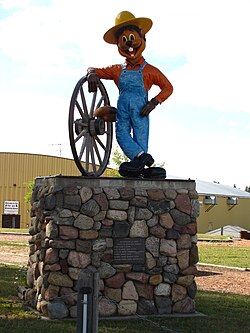 Clem T. GoFur | |
 Location of Torrington in Alberta | |
| Coordinates: 51°47′29″N 113°36′21″W / 51.7914°N 113.6058°W | |
| Country | Canada |
| Province | Alberta |
| Census division | No. 5 |
| Municipal district | Kneehill County |
| Government | |
| • Type | Unincorporated |
| • Governing body | Kneehill County Council |
| Area | |
| • Total | 0.63 km2 (0.24 sq mi) |
| Elevation | 950 m (3,120 ft) |
| Population (2016)[1] | |
| • Total | 170 |
| Time zone | UTC−7 (MST) |
| • Summer (DST) | UTC−6 (MDT) |

Torrington is a hamlet in central Alberta, Canada within Kneehill County.[2] It is located approximately 160 kilometres (99 mi) northeast of Calgary at the junction of Highway 27 and Highway 805.
The hamlet is located in Census Division No. 5 and in the federal riding of Crowfoot.
The main industry is agriculture.
The community is home to the Gopher Hole Museum, dedicated to stuffed Richardson's ground squirrels (technically not gophers) in anthropomorphic taxidermy settings.
A very large outdoor gopher sculpture[3] (12 ft high) named "Clem T. GoFur" is located in the village.
All 11 of Torrington's fire hydrants were painted to look like gophers.
Torrington was incorporated as a village until 1997, when it dissolved to hamlet status under the jurisdiction of Kneehill County.[4]
Demographics[]
As a designated place in the 2016 Census of Population conducted by Statistics Canada, Torrington recorded a population of 170 living in 83 of its 89 total private dwellings, a change of -5% from its 2011 population of 179. With a land area of 0.63 km2 (0.24 sq mi), it had a population density of 269.8/km2 (698.9/sq mi) in 2016.[1]
As a designated place in the 2011 Census, Torrington had a population of 179 living in 81 of its 90 total dwellings, a −2.7% change from its 2006 population of 184. With a land area of 0.69 km2 (0.27 sq mi), it had a population density of 259.4/km2 (672/sq mi) in 2011.[5]
See also[]
- List of communities in Alberta
- List of designated places in Alberta
- List of former urban municipalities in Alberta
- List of hamlets in Alberta
References[]
- ^ a b c "Population and dwelling counts, for Canada, provinces and territories, and designated places, 2016 and 2011 censuses – 100% data (Alberta)". Statistics Canada. February 8, 2017. Retrieved February 13, 2017.
- ^ "Specialized and Rural Municipalities and Their Communities" (PDF). Alberta Municipal Affairs. January 6, 2021. Retrieved September 29, 2021.
- ^ Alberta Travel. "Unusual Attractions". Retrieved 2007-11-20.
- ^ Alberta Municipal Affairs. "Kneehill County". Retrieved 2007-11-16.
- ^ "Population and dwelling counts, for Canada, provinces and territories, and designated places, 2011 and 2006 censuses (Alberta)". Statistics Canada. 2012-02-08. Retrieved 2012-04-07.
Places adjacent to Torrington, Alberta | |
|---|---|
| Subdivisions |
|
|---|---|
| Communities |
|
| Cities and urban service areas |
|
| Hamlets |
|
| |
Coordinates: 51°47′29″N 113°36′21″W / 51.79139°N 113.60583°W
- Designated places in Alberta
- Hamlets in Alberta
- Former villages in Alberta
- Kneehill County
- Populated places disestablished in 1997