List of cities in Alberta
A city is the highest form of all incorporated urban municipality statuses used in the Canadian Province of Alberta. Alberta cities are created when communities with populations of at least 10,000 people, where a majority of their buildings are on parcels of land smaller than 1,850 m², apply to Alberta Municipal Affairs for city status under the authority of the Municipal Government Act.[1] Applications for city status are approved via orders in council made by the Lieutenant Governor in Council under recommendation from the Minister of Municipal Affairs.[1]
Alberta has 19 cities that had a cumulative population of 2,837,511 (not including the population in the Saskatchewan portion of Lloydminster) and an average population of 149,343 in the 2016 Canadian Census.[2] Alberta's largest and smallest cities are Calgary and Wetaskiwin, with populations of 1,239,220 and 12,655, respectively.[2]
Beaumont became Alberta's 19th city on January 1, 2019.[3]
157 elected city officials (19 mayors and 138 councillors) provide city governance throughout the province.[4]
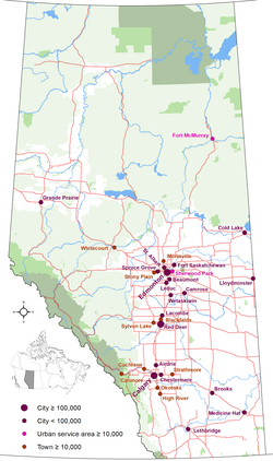
The highest density of cities in Alberta is found in the Edmonton Metropolitan Region (Beaumont, Edmonton, Fort Saskatchewan, Leduc, Spruce Grove and St. Albert). The Calgary Metropolitan Region has three cities (Airdrie, Calgary and Chestermere).
Administration[]
Pursuant to Part 5, Division 1 of the Municipal Government Act (MGA), each municipality created under the authority of the MGA is governed by an elected council. As a requirement of the MGA, a city council consists of an odd number of councillors, one of which is the city's chief elected official (CEO) or mayor. A city council consists of seven councillors by default, but it can consist of a higher or lower odd number if council passes a bylaw altering its size (so long as it does not consist of fewer than three councillors).[1]
City councils are governed by a mayor who is elected at large and an even number of councillors, resulting in a total odd number of councillors to avoid tie votes on council matters. For the councillors, a city council may establish ward systems, with councillors elected from wards that are defined as having roughly the same population (single-member districts or more than one member per district). Voters choose a councillor candidate running in the ward in which they live. If no ward system is in place, councillors are elected at-large like the mayor.[1][5]
All city councillors are elected by popular vote under the provisions of the Local Authorities Election Act (LAEA).[6] Mayoral or councillor candidates are required to be residents of their municipality for a minimum of six consecutive months prior to nomination day. The last municipal election for all cities, with the exception of the border city of Lloydminster, was held October 16, 2017. Lloydminster's elections are aligned with Saskatchewan's municipal election schedule.
Alberta Municipal Affairs, a ministry of the Cabinet of Alberta, is charged with coordination of all levels of local government.
Administrative duties of cities include public safety, local transit, roads, water service, drainage and waste collection, as well as coordination of infrastructure with provincial and regional authorities (including road construction, education, and health).

Calgary (2015)

Edmonton (2019)

Lethbridge (2009)

Red Deer (2008)

St. Albert (2009)
Grande Prairie (2014)


List[]
| Name | Region | Incorporation date (city)[7] |
Council size[7] |
Municipal census population (year)[8] |
Population (2016)[2] |
Population (2011)[2] |
Change (%)[2] |
Land area (km²)[2] |
Population density (per km²)[2] |
|---|---|---|---|---|---|---|---|---|---|
| Airdrie | Calgary Metropolitan Region | January 1, 1985 | 7 | 70,564 (2019) |
61,581 | 43,271 | +42.3% | 84.57 | 728.2/km2 |
| Beaumont[AB 1] | Edmonton Metropolitan Region | January 1, 2019 | 7 | 18,829 (2018) |
17,396 | 13,284 | +31.0% | 10.47 | 1,661.5/km2 |
| Brooks | Southern Alberta | September 1, 2005 | 7 | 14,185 (2015) |
14,451 | 13,676 | +5.7% | 18.59 | 777.4/km2 |
| Calgary[AB 2] | Calgary Metropolitan Region | January 1, 1894 | 15 | 1,267,344 (2018) |
1,239,220 | 1,096,833 | +13.0% | 825.56 | 1,501.1/km2 |
| Camrose | Central Alberta | January 1, 1955 | 9 | 18,044 (2016) |
18,742 | 17,286 | +8.4% | 42.62 | 439.7/km2 |
| Chestermere[AB 3] | Calgary Metropolitan Region | January 1, 2015[9] | 7 | 20,732 (2018) |
19,887 | 14,824 | +34.2% | 32.94 | 603.7/km2 |
| Cold Lake | Central Alberta | October 1, 2000 | 7 | 15,736 (2014) |
14,961 | 13,839 | +8.1% | 59.92 | 249.7/km2 |
| Edmonton[AB 4] | Edmonton Metropolitan Region | October 8, 1904 | 13 | 972,223 (2019) |
932,546 | 812,201 | +14.8% | 685.25 | 1,360.9/km2 |
| Fort Saskatchewan | Edmonton Metropolitan Region | July 1, 1985 | 7 | 26,328 (2018) |
24,149 | 19,051 | +26.8% | 48.18 | 501.2/km2 |
| Grande Prairie | Northern Alberta | January 1, 1958 | 9 | 69,088 (2018) |
63,166 | 55,655 | +13.5% | 132.73 | 475.9/km2 |
| Lacombe | Central Alberta | September 5, 2010 | 7 | 12,728 (2014) |
13,057 | 11,707 | +11.5% | 20.81 | 627.4/km2 |
| Leduc | Edmonton Metropolitan Region | September 1, 1983 | 7 | 32,448 (2018) |
29,993 | 24,304 | +23.4% | 42.44 | 706.7/km2 |
| Lethbridge | Southern Alberta | May 9, 1906 | 9 | 101,482 (2019) |
92,729 | 83,517 | +11.0% | 122.09 | 759.5/km2 |
| Lloydminster (part)[AB 5] | Central Alberta | January 1, 1958 | 7 | 19,740[AB 6] (2015) |
19,645[AB 7] | 18,032[AB 8] | +8.9% | 24.04 | 817.2/km2[AB 9] |
| Medicine Hat | Southern Alberta | May 9, 1906 | 9 | 63,018 (2015) |
63,260 | 60,005 | +5.4% | 112.04 | 564.6/km2 |
| Red Deer | Central Alberta | March 25, 1913 | 9 | 101,002 (2019) |
100,418 | 90,564 | +10.9% | 104.73 | 958.8/km2 |
| Spruce Grove | Edmonton Metropolitan Region | March 1, 1986 | 7 | 35,766 (2018) |
34,066 | 26,171 | +30.2% | 32.2 | 1,058.0/km2 |
| St. Albert | Edmonton Metropolitan Region | January 1, 1977 | 7 | 66,082 (2018) |
65,589 | 61,466 | +6.7% | 48.45 | 1,353.7/km2 |
| Wetaskiwin[AB 10] | Central Alberta | May 9, 1906 | 7 | 12,621 (2014) |
12,655 | 12,525 | +1.0% | 18.31 | 691.2/km2 |
| Total cities | — | — | 157 | — | 2,837,511 | 2,488,211 | +14.0% | 2,465.94 | 1,150.7/km2 |
Notes:
- ^ Beaumont is Alberta's newest city, incorporated on January 1, 2019. Based on 2016 data, Beaumont is Alberta's smallest city by land area, but in 2017 its area increased to nearly 2,400 hectares, making it larger than Wetaskiwin and Lacombe.[7]
- ^ Calgary is Canada's third-largest city, Alberta's largest city by both population and area, and was Alberta's first city, incorporated on January 1, 1894. The Calgary census metropolitan area (CMA) includes the cities of Airdrie, Calgary and Chestermere.
- ^ Chestermere was known as Chestermere Lake prior to March 1, 1993.[7]
- ^ Edmonton is Canada's fifth-largest city and Alberta's capital. The Edmonton CMA includes the cities of Beaumont, Edmonton, Fort Saskatchewan, Leduc, Spruce Grove and St. Albert.
- ^ The balance of Lloydminster is located within Saskatchewan.
- ^ This population does not include 11,637 in the Saskatchewan portion of Lloydminster. The city's total population in 2015 was 31,377.
- ^ This 2016 population does not include 11,765 in the Saskatchewan portion of Lloydminster. The city's total population in 2016 was 31,410.
- ^ This 2011 population does not include 9,772 in the Saskatchewan portion of Lloydminster. The city's total population in 2011 was 27,804.
- ^ This area does not include 18.28 km2 (7.06 sq mi) in the Saskatchewan portion of Lloydminster. The city's total land area in 2011 was 42.32 km2 (16.34 sq mi).
- ^ Wetaskiwin is Alberta's smallest city by population and land area.
Former cities[]
Alberta has recognized three other cities in its history. The Town of Strathcona incorporated as a city on March 15, 1907, and subsequently amalgamated with Edmonton on February 1, 1912. Fort McMurray was incorporated as a city on September 1, 1980, but reverted to its current urban service area form as a result of its amalgamation with Improvement District (I.D.) No. 143 on April 1, 1995.[10] The Town of Drumheller was incorporated as a city on April 3, 1930 (well before the current requirement to have a population in excess of 10,000 people), and reverted to town status on January 1, 1998, when it amalgamated with the surrounding Municipal District of Badlands No. 7.[11]
| Former city | Incorporation date (city) |
Previous status |
Date of status change |
Subsequent status |
|---|---|---|---|---|
| Drumheller | April 3, 1930 | Town | January 1, 1998 | Town |
| Fort McMurray | September 1, 1980 | New town | April 1, 1995 | Urban service area |
| Strathcona | March 15, 1907 | Town | February 1, 1912 | City amalgamation |
City status eligibility[]
There are currently ten towns – Blackfalds, Canmore, Cochrane, High River, Morinville, Okotoks, Stony Plain, Strathmore, Sylvan Lake and Whitecourt – that are eligible for city status having populations in excess of 10,000.[8] In addition, the Town of Hinton has expressed interest in incorporating as a city once it surpasses 10,000 people.[12] Its population in 2016 was 9,882.[2]
Alberta's two urban service areas – Fort McMurray and Sherwood Park – are also eligible for city status. As noted above, Fort McMurray was previously incorporated as a city until it amalgamated with I.D. No. 143 on April 1, 1995.[10] Meanwhile, Sherwood Park has remained a hamlet since its first residents arrived in 1955[13] and, in 1987, 89% of Strathcona County residents voted in favour of maintaining a single municipal government for Sherwood Park and the rural portion of the county.[14] If they were to incorporate as cities, Fort McMurray and Sherwood Park would rank fifth and sixth respectively among Alberta's largest cities by population.[8]
See also[]
- List of census divisions of Alberta
- List of communities in Alberta
- List of hamlets in Alberta
- List of municipal districts in Alberta
- List of municipalities in Alberta
- List of population centres in Alberta
- List of summer villages in Alberta
- List of towns in Alberta
- List of villages in Alberta
References[]
- ^ a b c d "Municipal Government Act". Alberta Queen's Printer. Retrieved March 15, 2010.
- ^ a b c d e f g h "Population and dwelling counts, for Canada, provinces and territories, and census subdivisions (municipalities), 2016 and 2011 censuses – 100% data (Alberta)". Statistics Canada. February 8, 2018. Retrieved January 12, 2019.
- ^ "Order in Council (O.C.) 395/2018". Government of Alberta. December 11, 2018. Retrieved January 12, 2019.
- ^ "Municipal Profiles (Cities)" (PDF). Alberta Municipal Affairs. January 11, 2019. Retrieved January 12, 2019.
- ^ "Types of Municipalities". Alberta Municipal Affairs. Retrieved March 15, 2010.
- ^ "Local Authorities Election Act". Alberta Queen's Printer. Retrieved March 21, 2010.
- ^ a b c d "City Municipal Profiles" (PDF). Alberta Municipal Affairs. April 17, 2019. Retrieved April 17, 2019.
- ^ a b c "2018 Municipal Affairs Population List" (PDF). Alberta Municipal Affairs. December 2018. ISBN 978-1-4601-4254-7. Retrieved January 1, 2019.
- ^ "O.C. 499/2014". Government of Alberta. December 19, 2014. Retrieved January 1, 2015.
- ^ a b "Location and History Profile – Regional Municipality of Wood Buffalo". Alberta Municipal Affairs. December 25, 2009. Retrieved January 1, 2010.
- ^ "Location and History Profile – Town of Drumheller". Alberta Municipal Affairs. December 25, 2009. Retrieved January 1, 2010.
- ^ "Town of Hinton Regular Meeting of Council Agenda (see page 113 of 157)". Town of Hinton. April 21, 2009. Retrieved December 9, 2009.
- ^ "Sherwood Park's history". Strathcona County. Retrieved June 17, 2010.
- ^ "Sherwood Park history – Local government". Strathcona County. Retrieved June 17, 2010.
External links[]
| Provinces |
|
|---|---|
| Territories |
|
| |
Subdivisions of Alberta | |
|---|---|
| Subdivisions | |
| Communities | |
| Cities and urban service areas | |
| |
| History | ||
|---|---|---|
| Politics | ||
| Geography | ||
| Communities |
| |
| Economy | ||
| Culture | ||
| ||
- Cities in Alberta
- Alberta-related lists
- Lists of cities in Canada
- Lists of populated places in Alberta