Strathcona County
Strathcona County | |
|---|---|
Specialized municipality | |
|
Logo | |
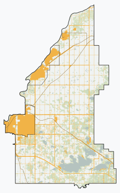 Josephburg South Cooking L. North Cooking L. Antler L. | |
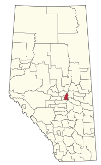 Location within Alberta | |
| Coordinates: 53°31′24″N 113°18′32″W / 53.52333°N 113.30889°WCoordinates: 53°31′24″N 113°18′32″W / 53.52333°N 113.30889°W | |
| Country | Canada |
| Province | Alberta |
| Region | Edmonton Metropolitan Region |
| Census division | No. 11 |
| - Municipal district | 1943 |
| - Specialized municipality | January 1, 1996 |
| Named for | Donald Smith, 1st Baron Strathcona and Mount Royal |
| Government | |
| • Mayor | Rod Frank |
| • Governing body | show
Strathcona County Council |
| • Seat | Sherwood Park |
| Area (2016)[4] | |
| • Land | 1,182.78 km2 (456.67 sq mi) |
| Population (2016)[4] | |
| • Total | 98,044 |
| • Density | 82.9/km2 (215/sq mi) |
| • Municipal census (2015) | 95,597[5] |
| Time zone | UTC-7 (MST) |
| • Summer (DST) | UTC-6 (MDT) |
| Website | strathcona.ca |

Strathcona County is a specialized municipality in central Alberta, Canada between Edmonton and Elk Island National Park.
It is located in Division No. 11 and is also part of the Edmonton Metropolitan Region. More than half of the population lives in Sherwood Park, a large community east of Edmonton that has opted to retain hamlet status. Strathcona County was designated as a specialized municipality on January 1, 1996, in order to accommodate the specific needs of an area that includes both urban and rural territory.[6]
History[]
In Treaty 6, the First Nations ceded their title to the land that would become Strathcona County.
First officially recognized in 1893 by the territorial legislature (it was then part of the North-West Territories) as Statute Labour District No. 2, Strathcona County has changed immensely since its inception. In 1913, Statute Labour District No. 2 was renamed to Local Improvement District No. 517 (Clover Bar), which then, in 1943, merged with Local Improvement District No. 518 (Strathcona) to become Municipal District No. 83 (Strathcona). By joining with local school divisions in 1962, Municipal District No. 83 officially became a county. County status was subsequently revoked in 1995 when the County Act was repealed by the provincial legislature, but was quickly returned in 1996 when the County of Strathcona No. 20 officially changed its name to Strathcona County and received specialized municipality status.[6]
On March 29, 2007, Strathcona County announced plans to create an entirely new urban community from scratch to complement Sherwood Park. This development was supposed to be more dense and pedestrian friendly, and could hold up to 200,000 people. However, opponents pointed out that the development would destroy land of high agricultural value.[7]
Demographics[]
In the 2016 Census of Population conducted by Statistics Canada, Strathcona County recorded a population of 98,044 living in 35,567 of its 36,354 total private dwellings, a change of 6% from its 2011 population of 92,490. With a land area of 1,182.78 km2 (456.67 sq mi), it had a population density of 82.9/km2 (214.7/sq mi) in 2016.[4]
The population of Strathcona County according to its 2015 municipal census is 95,597, a change of 3.5% from its 2012 municipal census population of 92,403.[5]
In the 2011 Census, Strathcona County had a population of 92,490 living in 33,129 of its 34,136 total dwellings, a change of 12.1% from its 2006 population of 82,511. With a land area of 1,180.56 km2 (455.82 sq mi), it had a population density of 78.3/km2 (202.9/sq mi) in 2011.[16]
Geography[]
Major highways[]
 Hwy 14
 Hwy 15
 Hwy 16 (TCH)
 Hwy 21
 Hwy 38
- SPF (Sherwood Park Freeway)
 Hwy 216
 Hwy 628
 Hwy 629
 Hwy 630
 Hwy 824
 Hwy 830
Airports[]
Strathcona County is home to two public airports.
Cooking Lake Airport, which operates as a condo board, accommodates 87 per cent of Strathcona County's public aeronautical transportation needs.[17][18] It is also the oldest operating public airport in Canada and approved for international flights under the Canada Border Services Agency CANPASS program.[19]
The Warren Thomas Aerodrome, better known as the Josephburg Airport, serves the remaining 13 per cent of Strathcona County's public aeronautical transportation needs.
Communities and localities[]
|
The following urban municipalities are surrounded by Strathcona County.
|
The following hamlets are located within Strathcona County.[21]
|
The following localities are located within Strathcona County.[22]
- Localities
|
|
|
|
Economy[]
Industrial[]
Strathcona County has over $12.0 billion worth of industrial projects completed, announced, or under construction.[23] This is aided in part by the concentration of oil refineries on the west side of Sherwood Park. This district, known as Refinery Row, includes some of the largest industrial facilities in Western Canada, such as Imperial's Strathcona Refinery. Originally built in the 1940s, a new refinery was constructed in 1976 and is one of the largest refining facilities in Canada.[24] As well, the Suncor's Edmonton Refinery produces 142,000 barrels per day (22,600 m3/d) of gasoline, diesel, jet fuel, and aviation gasoline. This refinery sits on 247 hectares of land and has been operating for over 65 years.[25] A founding member of Alberta's Industrial Heartland, Strathcona County is home to Canada's largest hydrocarbon refining cluster.[26]
The leading industries in Strathcona County as of 2020 are extraction, manufacturing, scientific, construction, trucking and engineering.
Commercial[]
Strathcona County is home to more than 11,000 businesses, with 3,500 of those businesses comprising employees. A market area population of 1.4 million has resulted in household spending power of $5.6 billion. Strathcona County has over 15,800 highly-skilled graduates available with 94% of residents holding a diploma, certificate, or degree. Within the active business community, there are several resources available to local entrepreneurs to help support their businesses:[27][28]
- Small Business Week and Conference
- Business Visitation Program
- Business Startup Seminars and Support
- Business Planning and Site Selection Resources
Government[]
Unlike most Albertan municipal districts, where council appoints a reeve, Strathcona County elects a mayor. Rod Frank was elected in 2017,[29] replacing Roxanne Carr who was elected in 2013.
Library[]
Strathcona County Library is a publicly funded library with its main branch in Sherwood Park. Its Bookmobile provides service to rural residents through 14 regular weekly stops.
See also[]
- List of communities in Alberta
- Specialized municipalities of Alberta
- Strathcona County Transit
References[]
- ^ Strathcona County (2010-04-27). "Local Government History". Strathcona County. Retrieved 2010-10-02.
- ^ Alberta Municipal Affairs (2010-09-17). "Municipal Profile – Strathcona County". Retrieved 2010-10-02.
- ^ "Municipal Officials Search". Alberta Municipal Affairs. September 22, 2017. Retrieved September 25, 2017.
- ^ Jump up to: a b c d "Population and dwelling counts, for Canada, provinces and territories, and census subdivisions (municipalities), 2016 and 2011 censuses – 100% data (Alberta)". Statistics Canada. February 8, 2017. Retrieved February 8, 2017.
- ^ Jump up to: a b "Census: Strathcona County Historical Population". Strathcona County. September 4, 2015. Retrieved September 5, 2015.
- ^ Jump up to: a b Municipality Profile - Alberta Municipal Affairs
- ^ New city rising
- ^ "Table 6a: Population by census divisions and subdivisions showing reorganization of rural areas, 1931-1946". Census of the Prairie Provinces, 1946. Volume I: Population. Ottawa: Dominion Bureau of Statistics. 1949. p. 424.
|volume=has extra text (help) - ^ "Table 6: Population by sex, for census subdivisions, 1956 and 1951". Census of Canada, 1956. Volume I: Population. Ottawa: Dominion Bureau of Statistics. 1958.
|volume=has extra text (help) - ^ "Table 9: Population by census subdivisions, 1966 by sex, and 1961". 1966 Census of Canada. Western Provinces. Population: Divisions and Subdivisions. Ottawa: Dominion Bureau of Statistics. 1967.
- ^ "Table 3: Population for census divisions and subdivisions, 1971 and 1976". 1976 Census of Canada. Census Divisions and Subdivisions, Western Provinces and the Territories. Population: Geographic Distributions. Ottawa: Statistics Canada. 1977.
- ^ "Table 2: Census Subdivisions in Alphabetical Order, Showing Population Rank, Canada, 1981". 1981 Census of Canada. Census subdivisions in decreasing population order. Ottawa: Statistics Canada. 1982. ISBN 0-660-51563-6.
- ^ "Table 2: Population and Dwelling Counts, for Census Divisions and Census Subdivisions, 1986 and 1991 – 100% Data". 91 Census. Population and Dwelling Counts – Census Divisions and Census Subdivisions. Ottawa: Statistics Canada. 1992. pp. 100–108. ISBN 0-660-57115-3.
- ^ "Population and Dwelling Counts, for Canada, Provinces and Territories, and Census Divisions, 2001 and 1996 Censuses – 100% Data (Alberta)". Statistics Canada. Retrieved 2019-05-25.
- ^ "Population and dwelling counts, for Canada, provinces and territories, and census subdivisions (municipalities), 2006 and 2001 censuses – 100% data (Alberta)". Statistics Canada. January 6, 2010. Retrieved 2019-05-25.
- ^ "Population and dwelling counts, for Canada, provinces and territories, and census subdivisions (municipalities), 2011 and 2006 censuses (Alberta)". Statistics Canada. 2012-02-08. Retrieved 2012-02-08.
- ^ Aubrianna, Snow (July 21, 2018). "Condo board that represents private airport wants public dollars". Forsaskonline.
- ^ Johannsson, Jim (August 10, 2018). "Airport continues fight on taxes". Sherwood Park News. Retrieved September 1, 2018.
- ^ Westhaver, Eric (September 23, 2015). "Edmonton-area airport now accepting international flights". Global News. Retrieved September 1, 2018.
- ^ "Fort Saskatchewan, City (Census Subdivision), Alberta". Statistics Canada. 2012-06-20. Retrieved 2012-08-13.
- ^ Jump up to: a b c d "Specialized and Rural Municipalities and Their Communities" (PDF). Alberta Municipal Affairs. 2012-03-01. Retrieved 2012-08-11.
- ^ "Standard Geographical Classification (SGC) 2006, Economic Regions: 4811052 - Strathcona County, geographical codes and localities, 2006". Statistics Canada. 2010-03-05. Retrieved 2012-08-11.
- ^ https://www.strathcona.ca/files/files/edt-strathconacounty-facts-2020-q1.pdf
- ^ https://www.imperialoil.ca/en-CA/Company/Operations/Strathcona
- ^ https://www.suncor.com/en-ca/about-us/refining/edmonton-refinery
- ^ https://strathconacounty.maps.arcgis.com/apps/Cascade/index.html?appid=c74ac01ff5d04c9a99338b2887b4ccc8
- ^ https://www.strathcona.ca/business-and-development/business/business-development/small-business-conference/
- ^ https://www.strathcona.ca/business-and-development/business/business-development/business-visitation-programs/
- ^ "2017 Election Results". Strathcona County. Retrieved 19 October 2017.
External links[]
| Wikimedia Commons has media related to Strathcona County. |
| show Places adjacent to Strathcona County |
|---|
| Authority control |
|
|---|
- Strathcona County
- 1943 establishments in Alberta
- Edmonton Metropolitan Region
- Specialized municipalities in Alberta