County of Warner No. 5
Warner No. 5 | |
|---|---|
| County of Warner No. 5 | |
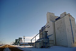 Last surviving elevator row in Alberta, located in Warner | |
|
Logo | |
 Location within Alberta | |
| Country | Canada |
| Province | Alberta |
| Region | Southern Alberta |
| Planning region | South Saskatchewan |
| Established | 1912 |
| Incorporated | 1950 |
| Government | |
| • Reeve | Ross Ford |
| • Governing body | County of Warner Council |
| • Administrative office | Warner |
| Area (2016)[2] | |
| • Land | 4,531.55 km2 (1,749.64 sq mi) |
| Population (2016)[2] | |
| • Total | 3,847 |
| • Density | 0.8/km2 (2/sq mi) |
| Time zone | UTC−7 (MST) |
| • Summer (DST) | UTC−6 (MDT) |
| Website | warnercounty.ca |

The County of Warner No. 5 is a municipal district in southern Alberta, Canada. Located in Census Division No. 2 just north of the United States border, its municipal office is located in the Village of Warner.
History[]
Warner was originally organised as a rural municipality in 1912. The County of Warner No. 5 was established in 1954.
Demographics[]
In the 2016 Census of Population conducted by Statistics Canada, the County of Warner No. 5 recorded a population of 3,847 living in 816 of its 941 total private dwellings, a 0.2% change from its 2011 population of 3,841. With a land area of 4,531.55 km2 (1,749.64 sq mi), it had a population density of 0.8/km2 (2.2/sq mi) in 2016.[2]
In the 2011 Census, the County of Warner No. 5 had a population of 3,841 living in 820 of its 956 total dwellings, a 5.1% change from its 2006 adjusted population of 3,654. With a land area of 4,517.67 km2 (1,744.28 sq mi), it had a population density of 0.9/km2 (2.2/sq mi) in 2011.[3]
Tourism and attractions[]


- Stirling Agricultural Village, National Historic Site of Canada
- Warner elevator row, last surviving "Grain Elevator Row" in Alberta.
- Galt Historic Railway Park
- Michelsen Farmstead
- William T. Ogden House
- Lost Frontier Mini-Railway
- Writing-on-Stone Provincial Park
- Devil's Coulee Dinosaur Heritage Museum
- Centennial Park
- Stirling Elevator
- Neils Hogenson House
- Andrew Larson House
- Temple Hill
- Raymond Golf Club
- Milk River Golf Club
Events[]
- Stirling Settler Days
- Victorian Prairie Christmas - Galt Railway Park
- Raymond Stampede
- Milk River Bonanza Days
- Coutts Days
- Warner Dino Days
History[]
The County of Warner No. 5 comprises approximately 50 townships, and is bordered on the south by the Canadian-United States border, It is composed of the former Municipal District of Warner No. 36 and a portion of the former Municipal District of Sugar City No. 37.
The following is the events that lead to the incorporation of the County of Warner No. 5:
- January, 1913 - Municipal District of Warner No. 36 incorporated.
- January 23, 1923 - Municipal District of Sugar City No. 37 incorporated.
- 1942 - Sugar City Municipality enlarged to include Local Improvement District No. 7 and portions of Local Improvement Districts 8, 38 and 67.
- January 6, 1950 - Warner Municipality enlarged to include Milk River, Coutts and Masinasin districts.
- December 31, 1953 - Sugar City dissolved and portion added to the Municipal District of Warner.
- January 1, 1954 - County of Warner No. 5 incorporated.
Communities and localities[]
|
The following urban municipalities are surrounded by the County of Warner No. 5:[4]
The following hamlets are located within the County of Warner No. 5:[4]
|
The following localities are located within the County of Warner No. 5:[5]
|
Education[]
Westwind School Division No. 74 and Horizon School Division No. 67 provide education within the boundaries of the County of Warner No. 5.
Early school districts[]
Listed below are the former school districts that once provided education within the County of Warner No. 5.[7]
| Name & SD No. | Image | Location | Date Established | Date Closed/ Disbanded |
Notes |
|---|---|---|---|---|---|
| Galt/Stirling No. 647 |  |
29 - 6 - 19 - W4 | 19 November 1901 | Originally named Galt, the name was changed to Stirling in 1957.[8] | |
| Raymond No. 700 | 8 - 6 - 20 - W4 | 1 May 1902[9] | |||
| Mammoth No. 1379 | 24 - 5 - 20 - W4 | 9 August 1905[10] | |||
| Warner No. 1675 | 10 - 4 - 17 - W4 | 31 July 1907[11] | |||
| Tyrells Lake No. 2007 | 20-5-17-W4 | 8 July 1909 | 1939 | Demolished 1940s[12] | |
| Milk River Valley/Masinasin No. 2024 | 15 - 2 - 13 - W4 | 24 August 1909 | Originally named Milk River Valley, the name was changed to Masinasin in 1941.[13] | ||
| Milk River No. 2056 | 15 - 2 - 13 - W4 | 8 October 1909[13] | |||
| Grain No. 2597 | 15-1-11-W4 | 25 November 1911[14] | |||
| West Butte/St. Kilda No. 2747 | 11-1-12-W4 | 25 May 1912 | Originally named West Butte, the name was changed to St. Kilda in 1920.[15] | ||
| Indian Rock No. 2540 | 18-1-12 -W4 moved? to 11 - 1 - 12 - W4 | 25 August 1911[16] | |||
| Locke No. 2730 | 31-1-13 -W4 Moved? to 28 - 2 - 13 - W4 | 10 May 1912[17] | |||
| Clarinda No. 2459 |  |
8-1-13 -W4 | 10 June 1911[18] | ||
| Verburg No. 2439 | 33-1-14 -W4 | 10 May 1911[19] | |||
| Sexton Creek No. 2510 | 9-1-14 -W4 moved? to 33 - 1 - 14 - W4 | 24 July 1911[20] | |||
| Lind No. 2170 | 34-1-16 -W4 | 25 April 1910[21] | |||
| John Joes No. 2198 | 24-1-17-W4 | 26 May 1910 | Also spelled John Jo[22] | ||
| Two Fifteen No. 2153 | 20-2-15-W4 | 26 March 1910 March 26 | Moved to Milk River for a class room when the district was joined with Milk River Consolidated District 12, December 1945[23] | ||
| Sleepy Hollow No. 2634 |  |
24-2-15-W4 | 25 January 1912[24] | ||
| Lucky Strike No. 2589 | 17-3-11-W4 | 9 November 1911[25] | |||
| Prairie Round No. 2152 | 21-3-12-W4 | 26 March 1910 March 26[26] | |||
| Patience No. 2156 | 23-6-17-W4 | 26 March 1910[27] | |||
| Maybutt |  |
32-6-19-W4 | 1910 | 1924 | Classes were first held at the Presbyterian Church, a vacant Chinese restaurant and later the Prairie Queen Hotel at the corner of First Avenue and Front Street, Maybutt. Plans to build a school house never got past the planning stages and children from Maybutt were bused to the neighbouring town of Stirling in 1924.[28] |
| Kippen No. 2080 | 34-2-12-W4 | 9 December 1909 | 1933 | Kippenville Consolidated 7 created in 1915 by Kippen & Green Villa disorganized in 1933[29] | |
| Bankview No. 3042 |  |
16-1-17-W4 | 1913 | 1953 | |
| Craddock/Bluesky No. 3456 | 33 - 81 - 2 - W6 | 15 February 1917 | Originally named Craddock, the name was changed to Bluesky in 1947.[30] | ||
| Coutts No. 3560 | 4 - 1 - 15 - W4 | 30 October 1917[31] | |||
| North Wrentham No. 3618 | 7 - 16 - W4 | 18 February 1918[32] | |||
| Wrentham No. 3617 | 36 - 6 - 17 - W4 | 18 February 1918[33] | |||
| Conrad No. 4077 | 11 - 61 - 12 - W4 | 3 November 1921[34] |
See also[]
References[]
- ^ "Municipal Officials Search". Alberta Municipal Affairs. September 22, 2017. Retrieved September 25, 2017.
- ^ Jump up to: a b c "Population and dwelling counts, for Canada, provinces and territories, and census subdivisions (municipalities), 2016 and 2011 censuses – 100% data (Alberta)". Statistics Canada. February 8, 2017. Retrieved February 8, 2017.
- ^ "Population and dwelling counts, for Canada, provinces and territories, and census subdivisions (municipalities), 2011 and 2006 censuses (Alberta)". Statistics Canada. February 8, 2012. Retrieved February 8, 2012.
- ^ Jump up to: a b "Specialized and Rural Municipalities and Their Communities" (PDF). Alberta Municipal Affairs. 2012-03-01. Archived from the original (PDF) on 2012-04-09. Retrieved 2012-08-12.
- ^ "Standard Geographical Classification (SGC) 2006, Economic Regions: 4802001 - Warner County No. 5, geographical codes and localities, 2006". Statistics Canada. 2010-03-05. Archived from the original on 2013-05-25. Retrieved 2012-08-12.
- ^ Two-Fifteen - Our Roots: Local Histories Online - Milk River Country
- ^ Early School Districts - Warner County No. 5, Alberta
- ^ Galt/Stirling S.D. 647 Archived July 27, 2011, at the Wayback Machine - Glenbow Museum Archives
- ^ Raymond S.D. 700 Archived July 27, 2011, at the Wayback Machine - Glenbow Museum Archives
- ^ Mommoth S.D. 1379 Archived July 27, 2011, at the Wayback Machine - Glenbow Museum Archives
- ^ Warner S.D. 1675 Archived July 27, 2011, at the Wayback Machine - Glenbow Museum Archives
- ^ Pioneering with a piece of chalk : the one-room country schools of Alberta, 1885-1982 - Tyrells Lake SD No. 2007
- ^ Jump up to: a b Milk River Valley/Masinasin S.D. 2024 Archived July 27, 2011, at the Wayback Machine - Glenbow Museum Archives
- ^ Grain S.D. 2597 Archived July 27, 2011, at the Wayback Machine - Glenbow Museum Archives
- ^ West Butte/St. Kilda S.D. 2747 Archived July 27, 2011, at the Wayback Machine - Glenbow Museum Archives
- ^ Indian Rock S.D. 2540 Archived July 27, 2011, at the Wayback Machine - Glenbow Museum Archives
- ^ Locke S.D. 2730 Archived July 27, 2011, at the Wayback Machine - Glenbow Museum Archives
- ^ Clarinda S.D. 2730 Archived July 27, 2011, at the Wayback Machine - Glenbow Museum Archives
- ^ Verburg S.D. 2439 Archived July 27, 2011, at the Wayback Machine - Glenbow Museum Archives
- ^ Sexton Creek S.D. 2510 Archived July 27, 2011, at the Wayback Machine - Glenbow Museum Archives
- ^ Lind S.D. 2170 Archived July 27, 2011, at the Wayback Machine - Glenbow Museum Archives
- ^ [Our Roots] - Pioneering with a piece of chalk : the one-room country schools of Alberta, 1885-1982 - John Joe SD No. 2198
- ^ Pioneering with a piece of chalk : the one-room country schools of Alberta, 1885-1982 - Two Fifteen SD No. 2153
- ^ Sleepy Hollow S.D. 2634 Archived July 27, 2011, at the Wayback Machine - Glenbow Museum Archives
- ^ Lucky Strike S.D. 2589 Archived July 27, 2011, at the Wayback Machine - Glenbow Museum Archives
- ^ Prairie Round S.D. 2152 Archived July 27, 2011, at the Wayback Machine - Glenbow Museum Archives
- ^ Patience S.D. 2156 Archived July 27, 2011, at the Wayback Machine - Glenbow Museum Archives
- ^ Stirling Its Story and People - Maybutt School - Page 191-192
- ^ Pioneering with a piece of chalk : the one-room country schools of Alberta, 1885-1982 - Kippen SD No. 2080
- ^ Craddock/Bluesky S.D. 3456 Archived July 27, 2011, at the Wayback Machine - Glenbow Museum Archives
- ^ Coutts S.D. 3560 Archived July 27, 2011, at the Wayback Machine - Glenbow Museum Archives]
- ^ North Wrentham S.D. 3618 Archived July 27, 2011, at the Wayback Machine
- ^ Wrentham S.D. 3617 Archived July 27, 2011, at the Wayback Machine
- ^ Conrad No. 4077 Archived July 27, 2011, at the Wayback Machine - Glenbow Museum Archives
External links[]
| show Places adjacent to County of Warner No. 5 |
|---|
| show Authority control |
|---|
Coordinates: 49°16′34″N 112°06′43″W / 49.27611°N 112.11194°W

- County of Warner No. 5
- Municipal districts in Alberta