Red Deer, Alberta
Red Deer | |
|---|---|
City | |
| City of Red Deer | |
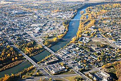 Aerial view of downtown Red Deer | |
 Coat of arms | |
| Motto(s): Education, Industry and Progress | |
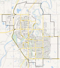 City boundaries | |
 Red Deer Location in Alberta | |
| Coordinates: 52°16′05″N 113°48′40″W / 52.26806°N 113.81111°WCoordinates: 52°16′05″N 113°48′40″W / 52.26806°N 113.81111°W | |
| Country | Canada |
| Province | Alberta |
| Planning region | Red Deer |
| Municipal district | Red Deer County |
| Founded | 1882 |
| Incorporated[2] | |
| • Village | May 31, 1894 |
| • Town | June 12, 1901 |
| • City | March 25, 1913 |
| Named for | Red Deer River |
| Government | |
| • Mayor | Tara Veer |
| • Governing body | |
| • City Manager | Allan Seabrooke |
| • MPs | Earl Dreeshen (CPC), Blaine Calkins (CPC) |
| • MLAs | Jason Stephan (UCP), Adriana LaGrange (UCP) |
| Area | |
| • Land | 104.73 km2 (40.44 sq mi) |
| • Urban | 62.91 km2 (24.29 sq mi) |
| Elevation | 855 m (2,805 ft) |
| Population | |
| • City | 100,418 |
| • Density | 958.8/km2 (2,483/sq mi) |
| • Urban | 99,718 |
| • Urban density | 1,585.2/km2 (4,106/sq mi) |
| • Municipal census (2019) | 101,002[6] |
| Demonym(s) | Red Deerian[5] |
| Time zone | UTC−7 (MST) |
| • Summer (DST) | UTC−6 (MDT) |
| Forward sortation areas | T4N - T4R |
| Area code(s) | 403, 587, 825 |
| Highways | 2, 2A, 11, 11A, 595 |
| Waterways | Red Deer River, Waskasoo Creek, Piper Creek |
| Website | reddeer.ca |


Red Deer is a city in central Alberta, Canada. It is located near the midpoint of the Calgary–Edmonton Corridor and is surrounded by Red Deer County. With a recorded population of 100,418 in the Canada 2016 census, Red Deer became the third Alberta city to surpass 100,000 people.[3] The city is located in aspen parkland, a region of rolling hills that is home to oil, grain, and cattle production. It is a centre for oil and agriculture distribution, and the surrounding region is a major centre for petrochemical production.
History[]
Prior to European settlement, the area was a gathering place that was inhabited by First Nations including the Blackfoot, Plains Cree and Stoney. European fur traders began passing through the area in the late eighteenth century. Into this ethnic mix, the Métis peoples also emerged.
A native trail ran from Montana Territory in the south across the Bow River near Calgary and on to Fort Edmonton. About halfway between Calgary and Edmonton, the trail crossed the Red Deer River at a wide, stony shallow used by First Nations and bison, commonly known as buffalo, since ancient times. The shallows, now known as the Old Red Deer Crossing, are about 7 kilometres (4.3 mi) upstream from the present City of Red Deer.
With the establishment of Fort Calgary by the North-West Mounted Police (NWMP) in 1875, traffic increased along what was by then known as the Calgary and Edmonton Trail.[8] After the arrival of the Canadian Pacific Railway in Calgary, traffic along the "C & E" trail increased substantially. A trading post and stopping house were built at the Crossing in 1882 and a permanent settlement began to develop around it.
The Crown gained title to the land that would later become the city in two treaties with First Nations: Treaty 6 in 1876 for the north side of the river, and Treaty 7 in 1877 for the south side.
During the 1885 North-West Rebellion, the Canadian militia constructed Fort Normandeau at the Crossing. The fort was later taken over by the NWMP, who used it until 1893.
With the decimation of the bison by hunters, the Aboriginal tribes who relied on them for food, clothing and shelter were also in decline. The fertile lands around the Red Deer River were attractive to farmers and ranchers. One early settler, the Reverend Leonard Gaetz, gave a half-share of 1,240 acres (5.0 km2) he had acquired to the Calgary and Edmonton Railway to develop a bridge over the river and a townsite. As a result, the Crossing was gradually abandoned. The first train from Calgary to Edmonton passed through Red Deer in 1891.
Etymology[]
Cree people called the river on which Red Deer stands Waskasoo Seepee, which translates to "Elk River". In the past the American elk was sometimes called "red deer", after the closely related Eurasian species. Later, the settlers of the area named their community after the river.[9] The name for the modern city in Plains Cree is a calque of the English name (mihkwâpisimosos, literally "red type of deer"), while the name of the river itself is still wâwâskêsiw-sîpiy or "elk river".[10]
Leonard Gaetz[]
Leonard Gaetz acted as the local land agent for the Saskatchewan Colonization Company and purchased parts of three other sections from his employers. By 1890, the Gaetz family owned vast land holdings along the south bank of the Red Deer River around the mouth of the Waskasoo Creek. The holdings included parts of Sections 16, 17, 20 and 21. Leonard Gaetz's increasing wealth allowed his family to play a central role in the growth of Red Deer.
In 1895, Gaetz returned to the active ministry in Manitoba. Once again, this proved detrimental to his health. He retired back to Red Deer in 1901, and resided here for the remainder of his life. He was a strong promoter of the area, founding the Westerner showgrounds and annual "Westerner Days", akin to the Calgary Stampede. He died in Red Deer in 1907.
1900 to 1929[]
Red Deer saw a massive influx of settlers in the early 1900s.
In 1901, when Red Deer was incorporated as a town, the population stood at 343. Through its location midway between Edmonton and Calgary and the fertile land that supported profitable mixed farming, Red Deer developed primarily as an agricultural service and distribution centre. A further boost came in 1907 when it was chosen as a major divisional point for the Canadian Pacific Railway. Two other railways, the Alberta Central Railway and the Canadian Northern Railway, entered the community in 1911. Red Deer underwent a large land boom.
On March 25, 1913, Red Deer was incorporated as a city and the population had jumped to nearly 2,800.
World War I brought a sharp end to the boom. Red Deer emerged as a small, quiet, but prosperous, prairie city. In 1922, the provincial institution for the care of the mentally handicapped, currently known as the Michener Centre, was established in the city. Prospects looked good for modest but sustainable growth. The migration of birds and other changes in ornithology of the area was recorded by citizen scientist Elsie Cassels ( in 1920s to 1930s) and contributed to the establishment of the Gaetz Lakes bird sanctuary.[11]
1930 to 1945[]
The Great Depression of the 1930s was a major setback for the city, though it fared better than some communities. Central Alberta was not hit by severe drought. The city was virtually debt-free and profited from its ownership of the local public utilities.
Growth returned to the city with the outbreak of World War II. Red Deer was chosen as the location of a large military training camp, the A-20 Camp which was located where Cormack Armoury, the Memorial Centre and Lindsay Thurber High School are now located. The British Commonwealth Air Training Plan built two air bases to the south of the city at Penhold and Bowden.
Post-Second World War[]
On January 1, 1948, the City of Red Deer amalgamated with the Village of North Red Deer, located on the north bank of the Red Deer River.[12][13]
In 1981, the city passed Lethbridge to become the third largest city in Alberta, a title it would hold until 2019, when Lethbridge regained its status.
By roughly 1991, the Canadian Pacific Railway had been removed from the inner city; the track currently runs parallel to the city outskirts. The most prominent landmark of the railway remaining is the CPR bridge spanning the Red Deer River, converted to a walking trail shortly after the track removal.[citation needed]
The city is now a centre for oil and natural gas extraction and related industries and also for agriculture and agricultural services. It is a regional centre for administration with a courthouse and provincial building. It also has major stores in malls such as Bower Place, Southpointe Common, Parkland Mall and many other locations.
Geography[]
Red Deer is located on the Red Deer River, from which it derives its name.
Climate[]
Red Deer has a humid continental climate (Köppen Dfb), with something of a semi-arid influence due to city's location within Palliser's Triangle. The highest temperature ever recorded in Red Deer was 37.2 °C (99 °F) on 8 July 1906,[14] 2 July 1924,[15] and 28 & 29 June 1937.[16] The coldest recorded temperature was −50.6 °C (−59 °F) on 17 December 1924.[17] The city lies in the 4a plant hardiness zone.[18] Summers are typically warm and rainy with cool nights. Winters are typically long, cold, and very dry.
| showClimate data for Red Deer, 1981−2010 normals, extremes 1904−present |
|---|
Neighbourhoods[]
Red Deer is divided into the following neighbourhoods:[23]
|
|
|
|
|
Demographics[]
| Year | Pop. | ±% |
|---|---|---|
| 1901 | 323 | — |
| 1906 | 1,418 | +339.0% |
| 1911 | 2,118 | +49.4% |
| 1916 | 2,203 | +4.0% |
| 1921 | 2,328 | +5.7% |
| 1926 | 2,021 | −13.2% |
| 1931 | 2,344 | +16.0% |
| 1936 | 2,384 | +1.7% |
| 1941 | 2,924 | +22.7% |
| 1946 | 4,042 | +38.2% |
| 1951 | 7,575 | +87.4% |
| 1956 | 12,338 | +62.9% |
| 1961 | 19,612 | +59.0% |
| 1966 | 26,171 | +33.4% |
| 1971 | 27,674 | +5.7% |
| 1976 | 32,184 | +16.3% |
| 1981 | 46,393 | +44.1% |
| 1986 | 54,425 | +17.3% |
| 1991 | 58,145 | +6.8% |
| 1996 | 60,075 | +3.3% |
| 2001 | 67,707 | +12.7% |
| 2006 | 82,772 | +22.3% |
| 2011 | 90,564 | +9.4% |
| 2016 | 100,418 | +10.9% |
| Source: Statistics Canada [24][25][26][27][28][29][30][31][32][33][34] [35][36][37][38][39][40][41][42][43][44][45][3] | ||
The population of the City of Red Deer according to its 2019 municipal census is 101,002,[6] a change of 1.2% from its 2016 municipal census population of 99,832.[46]
In the 2016 Census of Population conducted by Statistics Canada, the City of Red Deer recorded a population of 100,418 living in 39,982 of its 42,285 total private dwellings, a change of 10.9% from its 2011 population of 90,564. With a land area of 104.73 km2 (40.44 sq mi), it had a population density of 958.8/km2 (2,483.4/sq mi) in 2016.[3] The median age of Red Deer was 36.1, significantly lower than the national median age of 41.2.
As of 2016, Red Deer was approximately 77.4% white, 7.1% aboriginal and 15.5% visible minorities. The largest visible minority groups in Red Deer are Filipino (6.3%), Latin American (1.8%), Black (1.8%), South Asian (1.7%), Chinese (1.4%) and Southeast Asian (0.7%).
The majority (83.5%) of Red Deer residents identified English as their first language. Other common mother tongues were Tagalog (3.8%), Spanish (1.8%), French (1.3%), Chinese Languages (0.8%), and Arabic (0.8%).
In the 2011 Census, Red Deer had a population of 90,564 living in 36,346 of its 38,789 total dwellings, a change of 8.9% from its 2006 adjusted population of 83,154. With a land area of 104.29 km2 (40.27 sq mi), it had a population density of 868.4/km2 (2,249.1/sq mi) in 2011.[45]
Arts and culture[]
Named Cultural Capital of Canada by Canadian Heritage in 2003,[47] Red Deer is home to a wide variety of arts and cultural groups. It is the home of Central Alberta Theatre, Ignition Theatre, Red Deer Players Society, Bull Skit Comedy troupe, Central Music Festival, the Red Deer Symphony Orchestra, the Red Deer Museum + Art Gallery, the Red Deer Royals and other performing arts and fine arts organizations. The Red Deer Arts Council[48] is a member-based Multi-disciplinary Arts Service Organization and registered charity that serves the local and area community of visual, literary and performing artists.
Attractions[]
This section does not cite any sources. (November 2013) |
|
The Alberta Sports Hall of Fame is adjacent to the Queen Elizabeth II Highway (Highway 2) and the Greater Red Deer Visitor Centre.
The Canyon Ski Resort is located 7.5 km (4.7 mi) east of Red Deer.
The Enmax Centrium hosts sports events, concerts, trade shows and conventions. It is the home of the WHL’s Red Deer Rebels.
The 12,000 m2 (130,000 sq ft) G.H. Dawe Community Centre is shared by G.H. Dawe Community School, the G.H. Dawe Branch of the Red Deer Public Library, G.H. Dawe Centre Recreation Facility and St. Patrick's School.
The Greater Red Deer Visitor Centre is adjacent to the Queen Elizabeth II Highway (Highway 2) and the Alberta Sports Hall of Fame. |
The Recreation Centre, an older facility that has been upgraded to modern standards, has indoor and outdoor pools, steam rooms and hot tubs among other features.
Located beside the Recreation Centre, in downtown Red Deer. The Red Deer Museum has a permanent exhibit detailing the history of the region, and temporary exhibits that change every few months. It is also the venue of multiple educational programs for both adults and children.
Waskasoo Park meanders through Red Deer from its outskirts in the southwest, through the heart of the city, to its outskirts in the northeast along the Red Deer River. It includes over 80 kilometres (50 miles) of multi-use trails for biking, rollerblading, horseback riding, snowshoeing, cross-country skiing and walking. The park is one of the reasons Red Deer is known as "Park City".
The Westerner Exposition Grounds hosts events such as Agricon and Westerner Days. Held in early July, Westerner Days includes a rodeo, pony chuck-wagon racing, a fair, exhibitions and other events. |
Sports[]
Red Deer hosted the 2019 Canada Winter Games in February and March 2019.
The city is the hometown of several well-known sporting personalities, including former NHL players Ron Anderson, Blake Wesley, Glen Wesley, Trent Hunter, Chris Mason, Randy Moller, Brandon Sutter, Paul Postma and Mark Tinordi, and Olympic gold medallist Jamie Salé. Ron MacLean is also from Red Deer. Olympic medallist speed skater Jeremy Wotherspoon also spent most of his childhood in Red Deer after being born in Saskatchewan. Olympic bronze medallist Deidra Dionne grew up in Red Deer.
The Red Deer Rebels of the Western Hockey League play at Westerner Park Centrium. In 2018, Red Deer became the host of the Canadian Finals Rodeo, replacing Edmonton.[49]
The Red Deer Riggers of the Senior AAA Sunburst League play baseball at Great Chief Park. The team has been successful in recent years, winning provincial championships in 2009, 2010, 2013, 2014, and 2017.
Infrastructure[]
Transportation[]
The city is served by Red Deer Regional Airport, which serves mostly general aviation.
Red Deer Transit provides local bus service throughout the city.
Health care[]
Health care is provided at the Red Deer Regional Hospital.
Water[]
Red Deer receives its drinking water supply from the Red Deer River which is treated and distributed throughout the city.[50] One distinct feature of the water distribution system is the Horton Water Spheroid which, at the time of its construction in 1957, was the world's largest spheroid shaped reservoir.[51] Water from the Red Deer water treatment plant is distributed to neighbouring communities including Red Deer County, Lacombe, Blackfalds and Ponoka as managed by the North Red Deer Regional Water Services Commission.[52]
Wastewater[]
Wastewater is collected and sent to the City of Red Deer wastewater treatment plant which treats the sewage with a combination of grit traps, a primary clarifier, , secondary clarifiers, and UV disinfection. Solids generated from the treatment process are treated using dissolved air flotation, anaerobic digestion, and biosolids lagoons.[53] Treated effluent is then discharged back into the Red Deer River downstream of the water treatment plant.
Education[]
Secondary[]
Three school authorities operate schools in Red Deer:
Founded in 1887, the Red Deer Public School District[54] serves 10,000 students in thirty schools. Offering a wide range of programming, including French Immersion from K-12, the district not only meets the needs of children and youth from the City of Red Deer and welcomes international students from around the world. Lindsay Thurber Comprehensive High School and Hunting Hills High School provide a large number of program options for students of high school age.
Founded in 1909, when the Daughters of Wisdom, a religious order from France, accepted the challenge of the Tinchebray Fathers, also from France, to offer Catholic schooling in Red Deer, Red Deer Catholic Regional Schools[55] welcomes almost 7,000 students in five Central Alberta communities, including Red Deer. They operate École Secondaire Notre Dame High School and St. Joseph's High School.
Greater North Central Francophone Education Region No. 2's school École La Prairie is a French school located near downtown Red Deer that offers pre-kindergarten through grade 9 programs. It offers all courses in French to a population of 119 students[56] whose first language is French.
Post-secondary[]
Red Deer College was founded in 1964 as Red Deer Junior College. Today, it offers some degrees, adult upgrading, certificate programs, diploma programs, university transfer courses, applied degree programs, and apprenticeship and trades training.
Public schools[]
- Annie L. Gaetz Elementary (K–5)
- Aspen Heights Elementary (K–5)
- Barrie Wilson Elementary School (K–5)
- Don Campbell Elementary (K-5)
- Fairview Elementary (K–5)
- G.W. Smith Elementary (K–5)
- Gateway Christian School (K–5)
- G.H. Dawe Community School (K–8)
- Glendale School (K–8)
- Grandview Elementary (K–5)
- Joseph Welsh Elementary (K–5)
- Mattie McCullough Elementary (K–5)
- Mountview Elementary (K–5)
- Normandeau School (K–8)
- Oriole Park Elementary (K–5)
- Pines School (K–5)
- West Park Elementary (K–5)
- Central Middle School (6–8)
- Eastview Middle School (6–8)
- G.H. Dawe Community School (K–8)
- Gateway Christian School (6–8)
- Glendale School (K–8)
- Normandeau School (K–8)
- West Park Middle School (6–8)
- École Secondaire Lindsay Thurber Comprehensive High School (9–12)
- Gateway Christian School (9–12)
- Hunting Hills High School (9–12)
- North Cottage High School (10–12)
Catholic schools[]
- Elementary
-
- École Camille J. Lerouge School (PreK–9)
- École Mother Teresa School (K–5)
- École Our Lady of the Rosary School (K–2)
- Father Henri Voisin School (PreK–5)
- Holy Family School (PreK–5)
- Maryview School (PreK–5)
- St. Elizabeth Seton School (PreK–5)
- St. Marguerite Bourgeoys School (PreK–5)
- St. Martin de Porres School (PreK–5)
- St. Patrick's Community School (PreK–9)
- St. Teresa of Avila School (Prek-5)
- Middle school
-
- École Camille J. Lerouge School (PreK–9)
- St. Francis of Assisi Middle School (6–9)
- St. Patrick's Community School (PreK–9)
- St. Thomas Aquinas Middle School (6–9)
- Secondary/high school
-
- École Secondaire Notre Dame High School (10–12)
- St. Joseph's High School (10-12)
Private schools[]
- Destiny Christian School Society (ECS, K–9)
- Koinonia Christian School – Red Deer (ECS, K–12)
- Parkland School Special Education (1–12)
- South Side Christian School (ECS, K–12)
Media[]
This section needs expansion. You can help by . (July 2011) |
You can get the local news from Red Deer Advocate, rdnewsNOW and Today Ville. Edmonton CTV and Global News also carry Red Deer news. The City of Red Deer also releases regular updates.
See also[]
- List of cities in Alberta
- List of communities in Alberta
- Category:People from Red Deer, Alberta
References[]
- ^ "Municipal Officials Search". Alberta Municipal Affairs. September 22, 2017. Retrieved September 25, 2017.
- ^ "Location and History Profile: City of Red Deer" (PDF). Alberta Municipal Affairs. June 17, 2016. p. 99. Retrieved June 18, 2016.
- ^ Jump up to: a b c d e "Population and dwelling counts, for Canada, provinces and territories, and census subdivisions (municipalities), 2016 and 2011 censuses – 100% data (Alberta)". Statistics Canada. February 8, 2017. Retrieved February 8, 2017.
- ^ Jump up to: a b "Population and dwelling counts, for Canada, provinces and territories, and population centres, 2016 and 2011 censuses – 100% data (Alberta)". Statistics Canada. February 8, 2017. Retrieved February 8, 2017.
- ^ "Red Deerian Comes Out on Top". City of Red Deer. 2009-07-08. Retrieved 2011-06-07.
- ^ Jump up to: a b "Red Deer is home to 101,002 residents". City of Red Deer. June 24, 2019. Retrieved July 1, 2021.
- ^ "Alberta Private Sewage Systems 2009 Standard of Practice Handbook: Appendix A.3 Alberta Design Data (A.3.A. Alberta Climate Design Data by Town)" (PDF) (PDF). Safety Codes Council. January 2012. pp. 212–215 (PDF pages 226–229). Retrieved October 9, 2013.
- ^ Alberta Trail Net (December 2002). "Calgary and Edmonton Trail" (PDF). Archived from the original (PDF) on July 5, 2008. Retrieved 2009-09-14.
- ^ "History of Red Deer". City of Red Deer. Archived from the original on December 4, 2013. Retrieved November 15, 2013.
- ^ http://www.creedictionary.com/search/?q=Red+Deer&scope=0
- ^ Fish, fur & feathers : fish and wildlife conservation in Alberta 1905-2005. Federation of Alberta Naturalists., Fish and Wildlife Historical Society. Edmonton: Fish and Wildlife Historical Society. 2005. ISBN 0-9696134-7-4. OCLC 62181407.CS1 maint: others (link)
- ^ "North Red Deer: A Century of Change". City of Red Deer. 2011. Archived from the original on 2011-09-28. Retrieved 2011-07-24.
- ^ "2011 Village of North Red Deer Centennial Celebrations". City of Red Deer. 2011. Archived from the original on 2011-06-23. Retrieved 2011-07-24.
- ^ Jump up to: a b "July 1906". Canadian Climate Data. Environment Canada. Retrieved 18 May 2016.
- ^ Jump up to: a b "July 1924". Canadian Climate Data. Environment Canada. Retrieved 18 May 2016.
- ^ Jump up to: a b "June 1937". Canadian Climate Data. Environment Canada. Retrieved 18 May 2016.
- ^ Jump up to: a b "December 1924". Canadian Climate Data. Environment Canada. Retrieved 18 May 2016.
- ^ "Plant Hardiness Zone by Municipality". Natural Resources Canada. Government of Canada. Retrieved October 19, 2019.
- ^ "Red Deer". Canadian Climate Normals 1981–2010. Environment Canada. Retrieved May 14, 2014.
- ^ "Red Deer (1904–1974)". Canadian Climate Data. Environment Canada. Retrieved 18 May 2016.
- ^ "Red Deer A". Canadian Climate Normals 1981–2010. Environment Canada. Retrieved 18 May 2016.
- ^ "Canadian Climate Normals 1981-2010 Station Data". Environment Canada. Environment Canada. Retrieved 22 May 2016.
- ^ "Red Deer Open Data Catalogue: Neighbourhood Boundaries". City of Red Deer. Retrieved June 29, 2013.
- ^ "Table IX: Population of cities, towns and incorporated villages in 1906 and 1901 as classed in 1906". Census of the Northwest Provinces, 1906. Sessional Paper No. 17a. Ottawa: Government of Canada. 1907. p. 100.
- ^ "Table I: Area and Population of Canada by Provinces, Districts and Subdistricts in 1911 and Population in 1901". Census of Canada, 1911. Volume I. Ottawa: Government of Canada. 1912. pp. 2–39.
|volume=has extra text (help) - ^ "Table I: Population of Manitoba, Saskatchewan, and Alberta by Districts, Townships, Cities, Towns, and Incorporated Villages in 1916, 1911, 1906, and 1901". Census of Prairie Provinces, 1916. Population and Agriculture. Ottawa: Government of Canada. 1918. pp. 77–140.
- ^ "Table 8: Population by districts and sub-districts according to the Redistribution Act of 1914 and the amending act of 1915, compared for the census years 1921, 1911 and 1901". Census of Canada, 1921. Ottawa: Government of Canada. 1922. pp. 169–215.
- ^ "Table 7: Population of cities, towns and villages for the province of Alberta in census years 1901-26, as classed in 1926". Census of Prairie Provinces, 1926. Census of Alberta, 1926. Ottawa: Government of Canada. 1927. pp. 565–567.
- ^ "Table 12: Population of Canada by provinces, counties or census divisions and subdivisions, 1871-1931". Census of Canada, 1931. Ottawa: Government of Canada. 1932. pp. 98–102.
- ^ "Table 4: Population in incorporated cities, towns and villages, 1901-1936". Census of the Prairie Provinces, 1936. Volume I: Population and Agriculture. Ottawa: Dominion Bureau of Statistics. 1938. pp. 833–836.
|volume=has extra text (help) - ^ "Table 10: Population by census subdivisions, 1871–1941". Eighth Census of Canada, 1941. Volume II: Population by Local Subdivisions. Ottawa: Dominion Bureau of Statistics. 1944. pp. 134–141.
|volume=has extra text (help) - ^ "Table 6: Population by census subdivisions, 1926-1946". Census of the Prairie Provinces, 1946. Volume I: Population. Ottawa: Dominion Bureau of Statistics. 1949. pp. 401–414.
|volume=has extra text (help) - ^ "Table 6: Population by census subdivisions, 1871–1951". Ninth Census of Canada, 1951. Volume I: Population, General Characteristics. Ottawa: Dominion Bureau of Statistics. 1953. p. 6.73–6.83.
|volume=has extra text (help) - ^ "Table 6: Population by sex, for census subdivisions, 1956 and 1951". Census of Canada, 1956. Population, Counties and Subdivisions. Ottawa: Dominion Bureau of Statistics. 1957. p. 6.50–6.53.
- ^ "Table 6: Population by census subdivisions, 1901–1961". 1961 Census of Canada. Series 1.1: Historical, 1901–1961. Volume I: Population. Ottawa: Dominion Bureau of Statistics. 1963. p. 6.77-6.83.
|volume=has extra text (help) - ^ "Population by specified age groups and sex, for census subdivisions, 1966". Census of Canada, 1966. Population, Specified Age Groups and Sex for Counties and Census Subdivisions, 1966. Ottawa: Dominion Bureau of Statistics. 1968. p. 6.50–6.53.
- ^ "Table 2: Population of Census Subdivisions, 1921–1971". 1971 Census of Canada. Volume I: Population, Census Subdivisions (Historical). Ottawa: Statistics Canada. 1973. p. 2.102-2.111.
|volume=has extra text (help) - ^ "Table 3: Population for census divisions and subdivisions, 1971 and 1976". 1976 Census of Canada. Census Divisions and Subdivisions, Western Provinces and the Territories. Volume I: Population, Geographic Distributions. Ottawa: Statistics Canada. 1977. p. 3.40–3.43.
|volume=has extra text (help) - ^ "Table 4: Population and Total Occupied Dwellings, for Census Divisions and Subdivisions, 1976 and 1981". 1981 Census of Canada. Volume II: Provincial series, Population, Geographic distributions (Alberta). Ottawa: Statistics Canada. 1982. p. 4.1–4.10. ISBN 0-660-51095-2.
|volume=has extra text (help) - ^ "Table 2: Census Divisions and Subdivisions – Population and Occupied Private Dwellings, 1981 and 1986". Census Canada 1986. Population and Dwelling Counts – Provinces and Territories (Alberta). Ottawa: Statistics Canada. 1987. p. 2.1–2.10. ISBN 0-660-53463-0.
- ^ "Table 2: Population and Dwelling Counts, for Census Divisions and Census Subdivisions, 1986 and 1991 – 100% Data". 91 Census. Population and Dwelling Counts – Census Divisions and Census Subdivisions. Ottawa: Statistics Canada. 1992. pp. 100–108. ISBN 0-660-57115-3.
- ^ "Table 10: Population and Dwelling Counts, for Census Divisions, Census Subdivisions (Municipalities) and Designated Places, 1991 and 1996 Censuses – 100% Data". 96 Census. A National Overview – Population and Dwelling Counts. Ottawa: Statistics Canada. 1997. pp. 136–146. ISBN 0-660-59283-5.
- ^ "Population and Dwelling Counts, for Canada, Provinces and Territories, and Census Divisions, 2001 and 1996 Censuses - 100% Data (Alberta)". Statistics Canada. Retrieved 2012-04-01.
- ^ "Population and dwelling counts, for Canada, provinces and territories, and census subdivisions (municipalities), 2006 and 2001 censuses - 100% data (Alberta)". Statistics Canada. 2010-01-06. Retrieved 2012-04-01.
- ^ Jump up to: a b "Population and dwelling counts, for Canada, provinces and territories, and census subdivisions (municipalities), 2011 and 2006 censuses". Statistics Canada. 2012-02-08. Retrieved 2012-02-08.
- ^ 2016 Municipal Affairs Population List (PDF). Alberta Municipal Affairs. ISBN 978-1-4601-3127-5. Retrieved January 28, 2017.
- ^ City of Red Deer Document – Quality of Life http://www.reddeer.ca/NR/rdonlyres/E9BEC218-E486-4599-9E45-5168E10F9CF0/0/Qualityoflife.pdf[permanent dead link]
- ^ Hermary, Suzanne. "Coordinator". Red Deer Arts Council. Red Deer Arts Council. Retrieved 31 March 2021.
- ^ "It's official: Red Deer will host the CFR for 10 years". CBC News. Retrieved 2018-06-01.
- ^ The City of Red Deer. "Water Quality". Water Quality. City of Red Deer. Archived from the original on 2015-09-17. Retrieved July 30, 2015.
- ^ Mountview Heritage Sites Gallery. "Horton Water Spheroid". Retrieved July 30, 2015.
- ^ City of Red Deer. "Water Conservation". Archived from the original on 2015-09-17. Retrieved July 30, 2015.
- ^ The City of Red Deer. "Wastewater". Treating Your Wastewater. Archived from the original on 2015-05-12. Retrieved July 30, 2015.
- ^ Red Deer Public School District
- ^ "Red Deer Catholic Regional Division". Archived from the original on 2012-06-18. Retrieved 2012-06-25.
- ^ "Student Population by Grade, School, and Authority, 2011, p. 31" (PDF). Alberta Education. Retrieved 2011-04-01.
Further reading[]
- Meeres, E. L. (1978). The homesteads that nurtured a city: the history of Red Deer, 1880-1905. [s.l. : s.n.]
External links[]
| Wikivoyage has a travel guide for Red Deer. |
| hide | |
|---|---|
| Subdivisions | |
| Communities | |
| Cities and urban service areas |
|
| |
| show Authority control |
|---|
- Red Deer, Alberta
- 1894 establishments in the Northwest Territories
- Cities in Alberta
- Populated places established in 1882