Calgary–Edmonton Corridor
Calgary–Edmonton Corridor | |
|---|---|
Geographic region | |
 The corridor consists of Alberta's three most densely populated census divisions and two largest cities. | |
| Coordinates: 52°N 114°W / 52°N 114°WCoordinates: 52°N 114°W / 52°N 114°W | |
| Country | Canada |
| Province | Alberta |
| Area (2011)[1] | |
| • Total | 38,323.18 km2 (14,796.66 sq mi) |
| Population (2016)[2] | |
| • Total | 3,074,223 |
| • Density | 80.21/km2 (207.7/sq mi) |
| Time zone | UTC−7 (MST) |
| • Summer (DST) | UTC−6 (MDT) |
| Forward sortation areas | T1S to T1V, T1X to T4S, T4X to T7A, T7X to T8R, T8T, T9A, T9E to T9G, T0C (part), T0E (part) |
| Area code(s) | 403, 780, 587, 825 |
| Highways | 1, 1A, 2, 2A, 8, 11, 11A, 14, 15, 16, 16A, 19, 22X, 28, 28A, 37, 39, 60, 100, 201, 216, 595 |
| Waterways | Bow River, Elbow River, North Saskatchewan River, Red Deer River, Battle River, Blindman River, Medicine River, Rosebud River, Sturgeon River, Raven River, North Raven River, Sheep River, Little Bow River, Highwood River, Brazeau River |

The Calgary–Edmonton Corridor is a geographical region of the Canadian province of Alberta. It is the most urbanized area in Alberta and is one of Canada's four most urban regions.[3] It consists of Statistics Canada Alberta census divisions No. 11, No. 8, and No. 6. Measured from north to south, the region covers a distance of approximately 400 km (250 mi). It includes the entire census metropolitan areas of Calgary and Edmonton and the census agglomerations of Red Deer and Wetaskiwin.[4]
Transportation[]
Alberta Highway 2, also known as the Queen Elizabeth II Highway or QE2, is the busiest highway in Alberta and forms the central spine of the corridor.
A Canadian Pacific rail line, originally built by the Calgary and Edmonton Railway in 1891, roughly parallels the highway.[5] The line has been used exclusively by freight trains since 1985, when Via Rail discontinued its Calgary–South Edmonton train service.[6][7][8] There have been several proposal and studies for high-speed rail through the region.
The corridor has two of Canada's five busiest airports: Calgary International and Edmonton International. The number of daily flights between these two airports number into the dozens, making it one of Canada's busiest commuter flight routes.[9][10]
Demographics[]
In the Canada 2001 Census, the population of the Calgary–Edmonton Corridor was 2,149,586, representing 72.3% of Alberta's population.[11] In the Canada 2011 Census, the corridor's population had increased to 2,703,380 or 74.2% of the province's population. The population as of the Canada 2016 Census was 3,074,223.
The following presents the historic population growth of the Calgary–Edmonton Corridor between 1996 and 2016 by its three census divisions.
| Census division | Area (km2)[1] |
Pop. (2016)[2] |
Pop. (2011)[1] |
Pop. (2006)[12] |
Pop. (2001)[13] |
Pop. (1996)[13] |
|---|---|---|---|---|---|---|
| Division No. 6 | 12,645.88 | 1,498,778 | 1,311,022 | 1,160,936 | 1,021,060 | 880,859 |
| Division No. 8 | 9,909.31 | 209,395 | 189,243 | 175,337 | 153,049 | 133,592 |
| Division No. 11 | 15,767.99 | 1,366,050 | 1,203,115 | 1,076,103 | 975,477 | 898,888 |
| Calgary–Edmonton Corridor | 38,323.18 | 3,074,223 | 2,703,380 | 2,412,376 | 2,149,586 | 1,913,339 |
| Province of Alberta | 640,081.87 | 4,067,175 | 3,645,257 | 3,290,350 | 2,974,807 | 2,696,826 |
| Provincial proportion | 6.0% | 75.6% | 74.2% | 73.3% | 72.3% | 70.9% |
Growth[]
The Calgary–Edmonton Corridor is one of the fastest growing regions and wealthiest regions in Canada. A 2003 study by TD Bank Financial Group found the GDP per capita in the corridor is 10% above average compared to U.S. metropolitan areas and 40% above average compared to other Canadian cities. Much of this is because of large oil revenues due to the growing cost of oil since 2003.[14]
Census subdivisions[]
The following are lists of the census subdivisions within the Calgary Metropolitan Region and Edmonton Metropolitan Region portions of the Calgary–Edmonton Corridor. The Edmonton Metropolitan Region's eight summer villages are not listed.

Gallery[]
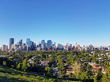
Calgary, the largest city in Alberta

Edmonton, the capital and the second largest city in Alberta

Red Deer, the third most populous city in the corridor, is located halfway between Calgary and Edmonton.


See also[]
References[]
- ^ a b c "Population and dwelling counts, for Canada, provinces and territories, and census divisions, 2011 and 2006 censuses (Alberta)". Statistics Canada. February 8, 2012. Retrieved June 25, 2012.
- ^ a b http://www12.statcan.gc.ca/census-recensement/2016/as-sa/fogs-spg/Facts-cd-eng.cfm?LANG=Eng&GK=CD&GC=4808
- ^ "2001 Census Analysis Series - A profile of the Canadian population : where we live" (PDF). Statistics Canada. p. 6. Retrieved August 17, 2011.
- ^ "Calgary–Edmonton Corridor: Population Change, 1996 – 2001 by 2001 Census Subdivision". Statistics Canada. 2002. Retrieved August 17, 2011.
- ^ "Network and facilities". www.cpr.ca. Retrieved September 2, 2019.
- ^ "The Western Trail". Via Rail. Retrieved September 2, 2019.
- ^ "Trains in Calgary". Tourism Calgary. Retrieved September 2, 2019.
- ^ "Rise and Fall of Passenger Rail in the Calgary-Edmonton Corridor". Forth Junction Project. Retrieved December 13, 2015.
- ^ "Passenger stats". EIA Corporate. Retrieved September 2, 2019.
- ^ "YYC > Media > Facts & Figures > Passenger Statistics". www.yyc.com. Retrieved September 2, 2019.
- ^ "Canada's major urban regions – The Calgary-Edmonton corridor". Statistics Canada. Retrieved August 17, 2011.
- ^ "Population and dwelling counts, for Canada, provinces and territories, and census divisions, 2006 and 2001 censuses - 100% data (Alberta)". Statistics Canada. January 6, 2010. Retrieved June 25, 2012.
- ^ a b "Population and Dwelling Counts, for Canada, Provinces and Territories, and Census Divisions, 2001 and 1996 Censuses - 100% Data (Alberta)". Statistics Canada. Retrieved June 25, 2012.
- ^ "The Calgary-Edmonton Corridor" (PDF). TD Bank Financial Group. April 22, 2003. Archived from the original (PDF) on July 23, 2004. Retrieved December 13, 2009.
External links[]
| Subdivisions | |
|---|---|
| Communities | |
| Cities and urban service areas | |
| Regions | |
| |
- Geographic regions of Alberta
- Transport corridors