Toyonaga Station
Toyonaga Station 豊永駅 | |
|---|---|
 Toyonaga Station in 2006 | |
| Location | Higashidoi, Ōtoyo, Nagaoka District, Kōchi Prefecture 789-0166 Japan |
| Coordinates | 33°47′48″N 133°45′36″E / 33.7968°N 133.7599°ECoordinates: 33°47′48″N 133°45′36″E / 33.7968°N 133.7599°E |
| Operated by | |
| Line(s) | ■ Dosan Line |
| Distance | 76.7 km from Tadotsu |
| Platforms | 1 island platform + 1 side platform (not in use) |
| Tracks | 2 + 1 siding |
| Construction | |
| Disabled access | No - overhead footbridge needed to access island platform |
| Other information | |
| Station code | D29 |
| History | |
| Opened | 28 October 1934 |
| Location | |
 Toyonaga Station Location within Japan | |

Toyonaga Station (豊永駅, Toyonaga-eki) is a railway station on the Dosan Line in Ōtoyo, Nagaoka District, Kōchi Prefecture, Japan. It is operated by JR Shikoku and has the station number "D29".[1][2]
Lines[]
The station is served by the JR Shikoku Dosan Line and is located 76.7 km from the beginning of the line at Tadotsu.[3][4]
Layout[]
The station consists of an island platform serving two tracks. The station building by the side of the tracks is unstaffed and serves as a waiting room. A pedestrian footbridge connects the station building with the island platform and also leads to a side platform (not used for passengers) serving a siding. There is a shelter on the island platform for waiting passengers.[2][5]
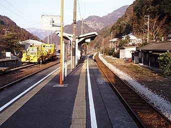
View of the station platforms in 2006 looking in the direction of Tadotsu

Adjacent stations[]
| « | Service | » | ||
|---|---|---|---|---|
| Dosan Line | ||||
| Tosa-Iwahara | - | Ōtaguchi | ||
History[]
The station opened on 28 October 1934 as the terminus of the then Kōchi Line which had been extended northwards from Ōsugi. At this time the station was operated by Japanese Government Railways, later becoming Japanese National Railways (JNR). With the privatization of JNR on 1 April 1987, control of the station passed to JR Shikoku.[3][6]
Surrounding area[]
- National Route 32 - runs parallel to the tracks on the other side of the station building. It is possible to access the station platforms and building from here as there is an entrance to the footbridge.[citation needed]
- National Route 439 - crosses the track and forms a junction with National Route 32 just southwest of the station.
See also[]
- List of Railway Stations in Japan
References[]
| Wikimedia Commons has media related to Toyonaga Station. |
- ^ "Shikoku Railway Route Map" (PDF). JR Shikoku. Retrieved 25 November 2017.
- ^ Jump up to: a b "豊永" [Toyonaga]. hacchi-no-he.net. Retrieved 15 December 2017.
- ^ Jump up to: a b Ishino, Tetsu; et al., eds. (1998). 停車場変遷大事典 国鉄・JR編 [Station Transition Directory - JNR/JR] (in Japanese). II. Tokyo: JTB Corporation. p. 665. ISBN 4533029809.
- ^ "Toyonaga Station Timetable" (PDF). JR Shikoku. Retrieved 15 December 2017.
- ^ Kawashima, Ryōzō (2007). Zenkoku Tetsudō Jijō Dai-kenkyū: Shikoku Hen (in Japanese). Sōshisha. pp. 114–115. ISBN 978-4-7942-1615-1.
- ^ Ishino, Tetsu; et al., eds. (1998). 停車場変遷大事典 国鉄・JR編 [Station Transition Directory - JNR/JR] (in Japanese). I. Tokyo: JTB Corporation. pp. 217–218. ISBN 4533029809.
- Stations of Shikoku Railway Company
- Railway stations in Kōchi Prefecture
- Railway stations in Japan opened in 1934