Trenton, Tennessee
Trenton, Tennessee | |
|---|---|
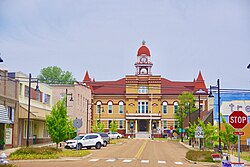 Gibson County Courthouse | |
| Motto(s): A tea-rrific place to live! | |
 Location of Trenton in Gibson County, Tennessee. | |
| Coordinates: 35°58′25″N 88°56′30″W / 35.97361°N 88.94167°WCoordinates: 35°58′25″N 88°56′30″W / 35.97361°N 88.94167°W | |
| Country | United States |
| State | Tennessee |
| County | Gibson |
| Established | 1824 |
| Incorporated | 1847 |
| Named for | Trenton, New Jersey[1] |
| Government | |
| • Mayor | Ricky Jackson (2015–) |
| Area | |
| • Total | 8.09 sq mi (20.95 km2) |
| • Land | 8.04 sq mi (20.81 km2) |
| • Water | 0.05 sq mi (0.14 km2) |
| Elevation | 331 ft (101 m) |
| Population (2010) | |
| • Total | 4,264 |
| • Estimate (2019)[5] | 4,180 |
| • Density | 520.09/sq mi (200.82/km2) |
| Time zone | UTC-6 (Central (CST)) |
| • Summer (DST) | UTC-5 (CDT) |
| ZIP code | 38382 |
| Area code(s) | 731 |
| FIPS code | 47-75000[3] |
| GNIS feature ID | 1304159[4] |
| Website | trentontn |

Trenton is a city in Gibson County, Tennessee, United States. The population was 4,264 at the 2010 census,[6] down from 4,683 in 2000. It is the county seat of Gibson County,[7] and its fourth largest city.
History[]
Trenton was established in 1824 as a county seat for the newly-created Gibson County. The site was initially home to a trading post known as "Gibson-Port" that was operated by Thomas Gibson, a brother of the county's namesake, Colonel John Gibson.[8] The city is named for Trenton, New Jersey.[1]
Geography[]
Trenton is located in central Gibson County at 35°58′25″N 88°56′30″W / 35.97361°N 88.94167°W (35.973627, −88.941569).[9] U.S. Route 45W passes through the east side of the city, bypassing downtown. It leads north 33 miles (53 km) to Union City and south 30 miles (48 km) to Jackson. Milan is 12 miles (19 km) to the southeast via Tennessee State Route 77, Bradford is 10 miles (16 km) to the northeast via State Route 54, Alamo is 18 miles (29 km) to the southwest, also via State Route 54, and Dyersburg is 26 miles (42 km) to the west via State Route 104.
According to the United States Census Bureau, the city of Trenton has a total area of 8.2 square miles (21.2 km2), of which 8.1 square miles (21.1 km2) are land and 0.04 square miles (0.1 km2), or 0.64%, are water.[6]
Demographics[]
| Historical population | |||
|---|---|---|---|
| Census | Pop. | %± | |
| 1850 | 694 | — | |
| 1860 | 1,908 | 174.9% | |
| 1870 | 1,900 | −0.4% | |
| 1880 | 1,383 | −27.2% | |
| 1890 | 1,693 | 22.4% | |
| 1900 | 2,328 | 37.5% | |
| 1910 | 2,402 | 3.2% | |
| 1920 | 2,751 | 14.5% | |
| 1930 | 2,892 | 5.1% | |
| 1940 | 3,400 | 17.6% | |
| 1950 | 3,868 | 13.8% | |
| 1960 | 4,225 | 9.2% | |
| 1970 | 4,226 | 0.0% | |
| 1980 | 4,601 | 8.9% | |
| 1990 | 4,836 | 5.1% | |
| 2000 | 4,683 | −3.2% | |
| 2010 | 4,264 | −8.9% | |
| 2019 (est.) | 4,180 | [5] | −2.0% |
| Sources:[10][11] | |||
As of the census[3] of 2000, there were 4,683 people, 1,919 households, and 1,207 families residing in the city. The population density was 847.3 people per square mile (327.0/km2). There were 2,090 housing units at an average density of 378.2 per square mile (145.9/km2). The racial makeup of the city was 65.17% White, 32.67% African American, 0.09% Native American, 0.26% Asian, 0.98% from other races, and 0.83% from two or more races. Hispanic or Latino of any race were 1.71% of the population.
There were 1,919 households, out of which 29.1% had children under the age of 18 living with them, 38.9% were married couples living together, 20.6% had a female householder with no husband present, and 37.1% were non-families. 34.1% of all households were made up of individuals, and 16.2% had someone living alone who was 65 years of age or older. The average household size was 2.29 and the average family size was 2.90.
In the city, the population was spread out, with 24.2% under the age of 18, 9.1% from 18 to 24, 26.1% from 25 to 44, 22.4% from 45 to 64, and 18.2% who were 65 years of age or older. The median age was 38 years. For every 100 females, there were 84.3 males. For every 100 females age 18 and over, there were 81.2 males.
The median income for a household in the city was $27,535, and the median income for a family was $39,630. Males had a median income of $29,675 versus $20,801 for females. The per capita income for the city was $16,225. About 12.9% of families and 17.6% of the population were below the poverty line, including 26.4% of those under age 18 and 19.5% of those age 65 or over.
Culture[]

Trenton is most famous for its collection of rare antique porcelain veilleuses, donated by the late Dr. Frederick C. Freed in 1955.[12] The teapots are unique because the candle's glow illuminates the pot's exterior, thus serving as a night light. None of the 525 teapots in this collection are alike, and some are designed as palaces or people in unique still-life castings. The town celebrates its collection with an annual "Teapot Festival" held each spring since 1981.

Trenton is also known for its unusual speed limit of 31 miles per hour (50 km/h), established by the city in the 1950s and posted by signs throughout the town.[13][14]
Nite Lite Theatre of Gibson County is a non-profit community theatre project based in Trenton, and established in 1980 with the intent of bringing theatrical presentations to Gibson and the surrounding counties. All work, with the exception of some production staff, is done on a volunteer basis. With most performances at Peabody High School, the history of Nite Lite Theatre includes performances of The Man Who Came to Dinner, The Sound of Music, Dearly Departed, and You Can't Take It with You.
Notable people[]
- Robert M. Bond, United States Air Force general
- Dave Brown, meteorologist and weatherman for Memphis TV station WMC channel 5, an NBC affiliate
- Eugenia Winwood (nee Crafton), wife of Steve Winwood; they married in 1987.
- John Wesley Crockett, member of the United States House of Representatives who was born in Trenton
- Gene Hickerson, Hall of Fame offensive lineman for the Cleveland Browns was born in Trenton
- Lew Jetton, known as a blues guitarist/singer, while also spending many years as a meteorologist and local television personality, was raised near Trenton
- Ben H. Love, eighth Chief Scout Executive of the Boy Scouts of America
- Peter Matthew Hillsman Taylor, author of the novel A Summons to Memphis, which won the Pulitzer Prize for Fiction in 1987
- Wallace Wade, college football coach
Education[]
Trenton Special School District operates Trenton's K-12 public schools. Peabody High School in Trenton was established in 1877. Dyersburg State Community College has a campus adjacent to Peabody High School.
Media[]
Radio stations:
- WPOT AM 1500 (simulcast with WJPJ) GoodNews Christian Network
- WTPR-AM 710 "The Greatest Hits of All Time"
Newspapers[]
- The Gazette (formerly The Herald Gazette)
Sports[]
The Trenton Reds, a Minor League Baseball team of the Kentucky–Illinois–Tennessee League, played in Trenton in 1922.[15] The city shared the same league's Milan-Trenton Twins with nearby Milan in 1923.[16]
References[]
- ^ Jump up to: a b Gibson County: Past and Present (Turner Publishing Company, 1961), pp. 70–71.
- ^ "2019 U.S. Gazetteer Files". United States Census Bureau. Retrieved July 30, 2020.
- ^ Jump up to: a b "U.S. Census website". United States Census Bureau. Retrieved January 31, 2008.
- ^ "US Board on Geographic Names". United States Geological Survey. October 25, 2007. Retrieved January 31, 2008.
- ^ Jump up to: a b "Population and Housing Unit Estimates". United States Census Bureau. May 24, 2020. Retrieved May 27, 2020.
- ^ Jump up to: a b "Geographic Identifiers: 2010 Demographic Profile Data (G001): Trenton city, Tennessee". American Factfinder. U.S. Census Bureau. Retrieved February 16, 2017.[dead link]
- ^ "Find a County". National Association of Counties. Retrieved June 7, 2011.
- ^ Fred M. Culp, "Gibson County," Tennessee Encyclopedia, 1 March 2018.
- ^ "US Gazetteer files: 2010, 2000, and 1990". United States Census Bureau. February 12, 2011. Retrieved April 23, 2011.
- ^ "Census of Population and Housing: Decennial Censuses". United States Census Bureau. Retrieved March 4, 2012.
- ^ "Incorporated Places and Minor Civil Divisions Datasets: Subcounty Resident Population Estimates: April 1, 2010 to July 1, 2012". Population Estimates. U.S. Census Bureau. Archived from the original on June 11, 2013. Retrieved December 11, 2013.
- ^ "Trenton Teapot Collection". Trenton Teapot Collection. Archived from the original on April 2, 2009. Retrieved February 24, 2009.
- ^ "'32' means you'll get a ticket", Ocala Star-Banner, September 16, 1977.
- ^ Randy Rauch, "Trenton's unique speed limit signs catch visitors' attention", WKRN-TV, July 31, 2013.
- ^ "1922 Trenton Reds Statistics". Baseball Reference. Sports Reference. Retrieved May 23, 2020.
- ^ "1923 Milan-Trenton Twins Roster". Stats Crew. Retrieved May 27, 2020.
External links[]
| Wikimedia Commons has media related to Trenton, Tennessee. |
| show Municipalities and communities of Gibson County, Tennessee, United States |
|---|
| show Authority control |
|---|
- Cities in Tennessee
- Cities in Gibson County, Tennessee
- County seats in Tennessee