Tropical Storm Zeta (2005)
| Tropical storm (SSHWS/NWS) | |
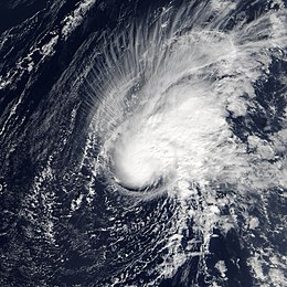 Tropical Storm Zeta at peak intensity in the open Atlantic on January 3 | |
| Formed | December 30, 2005 |
|---|---|
| Dissipated | January 7, 2006 |
| (Remnant low after January 6) | |
| Highest winds | 1-minute sustained: 65 mph (100 km/h) |
| Lowest pressure | 994 mbar (hPa); 29.35 inHg |
| Fatalities | None reported |
| Damage | None |
| Areas affected | None |
| Part of the 2005 Atlantic hurricane season | |
Tropical Storm Zeta was a very late-developing tropical storm that formed in the central Atlantic Ocean during the 2005 Atlantic hurricane season, one month after the season's official end. Becoming a tropical depression on December 30, and intensifying the following day into the season's 28th storm (including one unnamed subtropical storm), Zeta continued into January 2006.[1] It was one of only two Atlantic tropical cyclones to span two calendar years (the other being Hurricane Alice in 1954–55).
Zeta originated from an area of low pressure on December 29, which previously developed within an upper-level trough. After becoming a tropical storm, Zeta remained organized, defying predictions of a quick demise, and even grew slightly more intense. The storm reached its peak strength on January 2, 2006, before degenerating into a remnant low on January 6 and dissipating on the next day. Several ships encountered the storm, and several crews in the 2005 Woodvale Atlantic Rowing Race were affected by rough seas and high winds. Even so, as no land areas were threatened by Zeta, the NHC did not issue any tropical storm watches or warnings.[1]
Meteorological history[]

Tropical storm (39–73 mph, 63–118 km/h)
Category 1 (74–95 mph, 119–153 km/h)
Category 2 (96–110 mph, 154–177 km/h)
Category 3 (111–129 mph, 178–208 km/h)
Category 4 (130–156 mph, 209–251 km/h)
Category 5 (≥157 mph, ≥252 km/h)
Unknown
Tropical Storm Zeta originated from an upper-level trough that interacted with a weakening frontal system in late-December 2005. By December 28, the trough had developed into a low pressure area roughly 750 mi (1,210 km) west-northwest of the Cape Verde Islands. The following day, a low-level circulation developed and convective activity began to increase around the low. By December 30, sufficient shower and thunderstorm activity had developed for the National Hurricane Center (NHC) to classify it as a tropical cyclone, Tropical Depression 31. Over the following several hours, convective banding developed around the storm's center and by 0600 UTC, the depression intensified into Tropical Storm Zeta, the record 28th tropical or subtropical cyclone to form during the 2005 Atlantic hurricane season.[1] Operationally, however, the NHC did not begin issuing advisories on Zeta until 1700 UTC.[2] Traveling slowly northwestward in response to a mid-level low to the southwest, the storm gradually intensified in a region of favorable anticyclonic outflow.[1] By the afternoon of December 30, dry air caused the system to become slightly disorganized and led forecasters to anticipate further weakening of the storm, with Zeta forecast to dissipate within three days. In addition, there was evidence of some westerly wind shear beginning to impinge on the system at the time.[3]
Early on the next day, wind shear began affecting Zeta even more, with much of the convection east of the circulation center. However, the circulation remained tight and well-defined, and the storm maintained its intensity.[4] A few hours later, a deep burst of convection over the low-level circulation center allowed the storm to intensify a bit, with a central dense overcast forming.[5] A mid-level ridge to the north caused Zeta turn westward before nearly stalling due to upper-level westerlies.[1] An eye-like feature was briefly present, and the storm attained its initial peak intensity of 60 mph (95 km/h).[6] Soon after, increasing wind shear caused convection to become disorganized, resulting in a brief weakening period.[7]

On January 1, 2006, Zeta began re-organizing despite high shear, with outflow of the system becoming less restricted and the cloud pattern more symmetric.[8] Bursts of convection kept the storm alive in the face of moderate upper-level wind shear.[9] Zeta then began gradually intensifying. Convection remained over the center, and the storm's outflow expanded as well.[10] Around 1800 UTC that evening, Zeta attained its peak intensity with winds of 65 mph (100 km/h) and a barometric pressure of 994 hPa (29.35 inHg) about 1,035 mi (1,665 km) to the northwest of the Cape Verde Islands.[1] By January 2, the storm began tracking towards the southwest in response to a mid-level trough located east of the storm.[11] Tropical Storm Zeta continued to defy forecasts of weakening.[12]
The effects of wind shear finally took their toll late on January 4, and Zeta's convection began to die down. This led to Tropical Storm Zeta weakening to a minimal tropical storm. The NHC continued to overestimate how quickly Zeta would dissipate and early on January 5 they operationally downgraded Zeta to a depression, which was later confirmed to have been an error.[13] Zeta continued to move west-northwestward, barely holding on to tropical storm status before becoming disorganized again. Zeta weakened into a tropical depression on January 6 and degenerated into a remnant low later that day. With this transition, the very active 2005 hurricane season belatedly came to a close. The remnant low retained its identity for another day, before dissipating southeast of Bermuda during January 7.[1]
NHC forecaster James Franklin noted that the atmosphere "seem[ed] to want to develop tropical storms ad nauseam".[3] Due to the fact that Zeta, along with previous storms Epsilon and Vince, defied forecasts of weakening, the NHC remarked that they needed a better understanding of storms in the subtropics.[14]
Impact[]
Several of the crews that were taking part in the 2005 Atlantic Rowing Race were affected with heavy seas and strong adverse winds from Tropical Storm Zeta.[15] Several teams encountered winds up to 50 mph (85 km/h) and large swells up to 12 ft (3.7 m).[16] Although battered by torrential rain and high winds, the direction of the winds assisted some of the ships in the race by speeding them closer to Antigua.[17]
One Welsh vessel was blown 25 mi (40 km) off-course, ending with an encounter with a 12 ft (3.7 m) shark that battered their boat.[18] The ship Liberty Star made several reports of strong winds from Tropical Storm Zeta, including one of 40 mph (65 km/h) winds early on December 31, when the ship was about 45 miles (75 km) north of the storm.[1]
Records and distinctions[]
- First time that the sixth letter of the Greek alphabet was used as the name of an Atlantic tropical storm; this would not happen again until Hurricane Zeta in 2020.[19]
- Second latest-forming tropical cyclone ever recorded in an Atlantic hurricane season; only Hurricane Alice, which became a tropical storm around 1200 UTC on December 30, 1954, formed later (by about six hours).[1]
- One of only two Atlantic tropical cyclones, along with Hurricane Alice, known to have existed in two calendar years.[1]
- Extended the record number of storms to form in the 2005 season to 28; this mark would not be surpassed until the 2020 season.[20]
See also[]
- Other storms named Zeta
- List of off-season Atlantic hurricanes
- Timeline of the 2005 Atlantic hurricane season
References[]
- ^ a b c d e f g h i j Richard D. Knabb; Daniel P. Brown (March 17, 2006). Tropical Cyclone Report Tropical Storm Zeta (PDF) (Report). Miami, Florida: National Hurricane Center. Retrieved October 5, 2020.
- ^ James Franklin (December 30, 2005). "Tropical Storm Zeta Discussion Number One". National Hurricane Center. Retrieved January 9, 2010.
- ^ a b James Franklin (December 30, 2005). "Tropical Storm Zeta Discussion Number Two". National Hurricane Center. Retrieved January 9, 2010.
- ^ Richard Knabb (December 31, 2005). "Tropical Storm Zeta Discussion Number 3". National Hurricane Center. Retrieved October 31, 2020.
- ^ Stacy Stewart (December 31, 2005). "Tropical Storm Zeta Discussion Number 4". National Hurricane Center. Retrieved October 31, 2005.
- ^ James Franklin (December 31, 2005). "Tropical Storm Zeta Discussion Number 5". National Hurricane Center. Retrieved October 31, 2005.
- ^ James Franklin (December 31, 2005). "Tropical Storm Zeta Discussion Number 6". National Hurricane Center. Retrieved October 31, 2005.
- ^ Richard Pasch (December 31, 2005). "Tropical Storm Zeta Discussion Number 10". National Hurricane Center. Retrieved October 31, 2005.
- ^ Stacy Stewart (December 31, 2005). "Tropical Storm Zeta Discussion Number 12". National Hurricane Center. Retrieved October 31, 2005.
- ^ James Franklin (December 31, 2005). "Tropical Storm Zeta Discussion Number 16". National Hurricane Center. Retrieved October 31, 2005.
- ^ Lixion A. Avila (January 1, 2006). "Tropical Storm Zeta Discussion Eleven". National Hurricane Center. Retrieved January 9, 2010.
- ^ National Hurricane Center. "Discussion for Tropical Storm Zeta, 10 a.m. EST, January 4, 2006". NOAA. Retrieved May 1, 2006.
- ^ National Hurricane Center. "Discussion for Tropical Storm Zeta, 4 a.m. EST, January 5, 2006". NOAA. Retrieved May 1, 2006.
- ^ Richard Pasch (January 2, 2006). "Tropical Storm Zeta Discussion NUmber 14". National Hurricane Center. Retrieved October 31, 2020.
- ^ Woodvale Events Ltd. "Atlantic Rowing Race 2005 Press Release: Tropical Storm Zeta". Archived from the original on September 28, 2011. Retrieved May 1, 2006.
- ^ Sophy Williams (2005). "At sea, Tropical Storm Zeta makes waves the size of houses for Atlantic rowers" (PDF). BYM News. Retrieved January 9, 2010.
- ^ Richard Mayon-White; Liz O'Keeffe (January 4, 2006). "At sea. Atlantic Rowing Challenge: Tropical Storm Zeta affects Row 4 Cancer". BYM News. Archived from the original on March 23, 2012. Retrieved January 9, 2010.
- ^ Nathan Bevan (January 29, 2006). "Rower in terrifying shark ordeal". Wales Online. Retrieved January 9, 2010.
- ^ Miller, Kimberly (October 25, 2020) [Updated October 26, 2020]. "Tropical Storm Zeta forms with sights set on Gulf Coast, could be a hurricane by late Monday". USA Today. Retrieved November 1, 2020.
- ^ Cappucci, Matthew (November 9, 2020). "The 2020 Atlantic hurricane season is busiest on record as Subtropical Storm Theta forms". The Washington Post. Retrieved November 10, 2020.
External links[]
| Wikimedia Commons has media related to Tropical Storm Zeta (2005). |
| Wikinews has related news: |
Tropical cyclones of the 2005 Atlantic hurricane season | ||
|---|---|---|
 | ||
| ||
- 2005 Atlantic hurricane season
- Atlantic tropical storms
- Off-season Atlantic tropical cyclones
- Tropical cyclones in 2005
- Tropical cyclones in 2006