Two Medicine River
| Two Medicine River | |
|---|---|
 | |
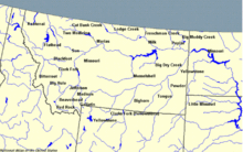 Montana rivers with Two Medicine in the north central | |
| Location | |
| Country | Pondera and Glacier County, Montana |
| Physical characteristics | |
| Source | |
| • coordinates | 48°29′32″N 113°15′49″W / 48.49222°N 113.26361°W[1] |
| Mouth | |
• coordinates | 48°29′11″N 112°13′40″W / 48.48639°N 112.22778°WCoordinates: 48°29′11″N 112°13′40″W / 48.48639°N 112.22778°W[1] |
• elevation | 3,294 feet (1,004 m)[1] |
| Discharge | |
| • location | Browning |
| • average | 375 cu ft/s (10.6 m3/s)[2] |
| Basin features | |
| River system | Missouri River |

The Two Medicine River is a tributary of the Marias River, approximately 60 mi (97 km) long, in northwestern Montana in the United States.
It rises in the Rocky Mountain Front in Glacier National Park at the continental divide and flows east, down from the mountains and across the Blackfeet Indian Reservation. It receives Birch Creek in southeastern Glacier County and joins Cut Bank Creek to form the Marias, approximately 12 mi (19 km) southeast of Cut Bank.
See also[]
Notes[]

| show Authority control |
|---|
Categories:
- Landforms of Glacier National Park (U.S.)
- Rivers of Montana
- Rivers of Glacier County, Montana
- Bodies of water of Pondera County, Montana