Fallon County, Montana
Fallon County | |
|---|---|
 Fallon County Courthouse in Baker | |
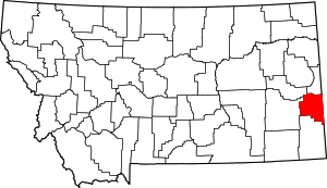 Location within the U.S. state of Montana | |
 Montana's location within the U.S. | |
| Coordinates: 46°21′N 104°25′W / 46.35°N 104.41°W | |
| Country | |
| State | |
| Founded | December 9, 1913 |
| Seat | Baker |
| Largest city | Baker |
| Area | |
| • Total | 1,623 sq mi (4,200 km2) |
| • Land | 1,621 sq mi (4,200 km2) |
| • Water | 2.3 sq mi (6 km2) 0.1% |
| Population (2010) | |
| • Total | 2,890 |
| • Estimate (2020) | 2,826 |
| • Density | 1.8/sq mi (0.69/km2) |
| Time zone | UTC−7 (Mountain) |
| • Summer (DST) | UTC−6 (MDT) |
| Congressional district | At-large |
| Website | www |
| |
Fallon County is a county located in the U.S. state of Montana. As of the 2010 United States Census, the population was 2,890.[1] Its county seat is Baker.[2] The county was created in 1913 from a portion of Custer County. It is named for Benjamin O'Fallon, a nephew of Captain William Clark and an Indian agent for the upper Missouri region from 1823 to 1827.[3]
Geography[]
According to the U.S. Census Bureau, the county has a total area of 1,623 square miles (4,200 km2), of which 1,621 square miles (4,200 km2) is land and 2.3 square miles (6.0 km2) (0.1%) is water.[4]
Adjacent counties[]
- Wibaux County - north
- Prairie County - northwest
- Custer County - west
- Carter County - south
- Harding County, South Dakota - southeast
- Bowman County, North Dakota - east
- Slope County, North Dakota - east
- Golden Valley County, North Dakota - northeast
Politics[]
Demographics[]
| Historical population | |||
|---|---|---|---|
| Census | Pop. | %± | |
| 1920 | 4,548 | — | |
| 1930 | 4,568 | 0.4% | |
| 1940 | 3,719 | −18.6% | |
| 1950 | 3,660 | −1.6% | |
| 1960 | 3,997 | 9.2% | |
| 1970 | 4,050 | 1.3% | |
| 1980 | 3,763 | −7.1% | |
| 1990 | 3,103 | −17.5% | |
| 2000 | 2,837 | −8.6% | |
| 2010 | 2,890 | 1.9% | |
| 2020 (est.) | 2,826 | [6] | −2.2% |
| US Decennial Census[7] 1790-1960[8] 1900-1990[9] 1990-2000[10] 2010-2020[1] | |||
2000 census[]
As of the 2000 United States Census, there were 2,837 people, 1,140 households, and 803 families living in the county. The population density was 2 people per square mile (1/km2). There were 1,410 housing units at an average density of 1 per square mile (0/km2). The racial makeup of the county was 98.59% White, 0.14% Black or African American, 0.32% Native American, 0.35% Asian, 0.04% Pacific Islander, 0.11% from other races, and 0.46% from two or more races. 0.39% of the population were Hispanic or Latino of any race. 39.4% were of German, 16.9% Norwegian, 10.0% Irish and 8.2% English ancestry. 97.2% spoke English and 1.7% German as their first language.
There were 1,140 households, out of which 32.10% had children under the age of 18 living with them, 60.50% were married couples living together, 6.00% had a female householder with no husband present, and 29.50% were non-families. 26.60% of all households were made up of individuals, and 13.20% had someone living alone who was 65 years of age or older. The average household size was 2.45 and the average family size was 2.96.
The county population contained 25.50% under the age of 18, 6.20% from 18 to 24, 25.50% from 25 to 44, 24.80% from 45 to 64, and 17.90% who were 65 years of age or older. The median age was 41 years. For every 100 females there were 102.20 males. For every 100 females age 18 and over, there were 96.70 males.
The median income for a household in the county was $29,944, and the median income for a family was $38,636. Males had a median income of $27,045 versus $18,077 for females. The per capita income for the county was $16,014. About 9.50% of families and 12.50% of the population were below the poverty line, including 17.50% of those under age 18 and 6.60% of those age 65 or over.
2010 census[]
As of the 2010 United States Census, there were 2,890 people, 1,233 households, and 810 families living in the county.[11] The population density was 1.8 inhabitants per square mile (0.69/km2). There were 1,470 housing units at an average density of 0.9 per square mile (0.35/km2).[12] The racial makeup of the county was 97.4% white, 0.6% Asian, 0.4% American Indian, 0.1% Pacific islander, 0.1% black or African American, 0.2% from other races, and 1.3% from two or more races. Those of Hispanic or Latino origin made up 1.2% of the population.[11] In terms of ancestry, 53.0% were German, 24.8% were Irish, 12.1% were Norwegian, 10.6% were English, 5.3% were Scotch-Irish, and 0.4% were American.[13]
Of the 1,233 households, 28.4% had children under the age of 18 living with them, 56.0% were married couples living together, 5.7% had a female householder with no husband present, 34.3% were non-families, and 30.1% of all households were made up of individuals. The average household size was 2.32 and the average family size was 2.88. The median age was 42.9 years.[11]
The median income for a household in the county was $52,529 and the median income for a family was $64,500. Males had a median income of $41,570 versus $30,000 for females. The per capita income for the county was $26,819. About 5.7% of families and 8.5% of the population were below the poverty line, including 16.3% of those under age 18 and 3.4% of those age 65 or over.[14]
Transportation[]
Major highways[]
Airport[]
The Baker Municipal Airport is southeast of Baker.[15]
Communities[]
Cities[]
- Baker (county seat)
Towns[]
Unincorporated communities[]
See also[]
- List of lakes in Fallon County, Montana
- List of mountains in Fallon County, Montana
- National Register of Historic Places listings in Fallon County, Montana
References[]
- ^ Jump up to: a b "State & County QuickFacts". US Census Bureau. Archived from the original on June 6, 2011. Retrieved September 15, 2013.
- ^ "Find a County". National Association of Counties. Archived from the original on May 31, 2011. Retrieved June 7, 2011.
- ^ "Montana Place Names Companion". Montana Place Names From Alzada to Zortman. Montana Historical Society Research Center. Retrieved May 9, 2011.
- ^ "2010 Census Gazetteer Files". US Census Bureau. August 22, 2012. Archived from the original on December 5, 2014. Retrieved November 28, 2014.
- ^ Leip, David. "Atlas of US Presidential Elections". uselectionatlas.org. Retrieved April 2, 2018.
- ^ "County Population Totals: 2010-2020". Retrieved July 7, 2021.
- ^ "US Decennial Census". US Census Bureau. Retrieved November 28, 2014.
- ^ "Historical Census Browser". University of Virginia Library. Retrieved November 28, 2014.
- ^ "Population of Counties by Decennial Census: 1900 to 1990". US Census Bureau. Retrieved November 28, 2014.
- ^ "Census 2000 PHC-T-4. Ranking Tables for Counties: 1990 and 2000" (PDF). US Census Bureau. Retrieved November 28, 2014.
- ^ Jump up to: a b c "Profile of General Population and Housing Characteristics: 2010 Demographic Profile Data". US Census Bureau. Archived from the original on February 13, 2020. Retrieved January 9, 2016.
- ^ "Population, Housing Units, Area, and Density: 2010 - County". US Census Bureau. Archived from the original on February 13, 2020. Retrieved January 9, 2016.
- ^ "Selected Social Characteristics in the US – 2006-2010 American Community Survey 5-Year Estimates". US Census Bureau. Archived from the original on February 13, 2020. Retrieved January 9, 2016.
- ^ "Selected Economic Characteristics – 2006-2010 American Community Survey 5-Year Estimates". US Census Bureau. Archived from the original on February 13, 2020. Retrieved January 9, 2016.
- ^ FAA Airport Form 5010 for BHK PDF. Federal Aviation Administration. Effective June 30, 2011.
- ^ Cabin Creek, Fallon County MT Google Maps (accessed January 1, 2019)
- ^ Ollie, Fallon County MT Google Maps (accessed January 1, 2019)
- ^ Webster, Fallon County MT Google Maps (accessed January 1, 2019)
- ^ Westmore, Fallon County MT Google Maps (accessed January 1, 2019)
External links[]
| show Places adjacent to Fallon County, Montana |
|---|
| show Municipalities and communities of Fallon County, Montana, United States |
|---|


| show Authority control |
|---|
- Montana counties
- Fallon County, Montana
- 1913 establishments in Montana
- Populated places established in 1913